Long Island Finally Clears Out After A Month’s Rain in 3 Days

Weather in 5/Joe & Joe Weather Show Latest Podcast
Long Island Finally Clears Out After A Month’s Rain in 3 Days
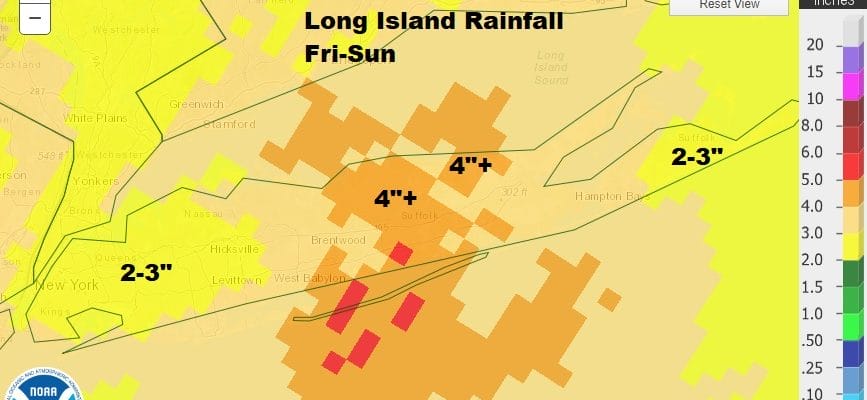
It took all day but finally the entire island from west to east is out of the clouds. At least it didn’t rain today and you could use your barbecue to cook your food instead of keeping you warm. The satellite shows lots of clouds now to the east and northeast of Long Island and we should have a nice clear night though cool with most lows by morning in the low 50s Rainfall amounts on Long Island over the three day period averaged 3 to 4 inches with a small area in Central Long Island finishing up between 4 and 4 1/2 inches so basically it was a month’s worth of rain in 3 days.
SATELLITE

Rainfall amounts on Long Island over the three day period averaged 3 to 4 inches with a small area in Central Long Island finishing up between 4 and 4 1/2 inches so basically it was a month’s worth of rain in 3 days.

Of course now that the holiday weekend is over, nice weather returns for Tuesday with sunshine. Temperatures should reach the mid 70s by afternoon. We have a ridge of high pressure off the East Coast so the return flow will bring more humidity Wednesday and Thursday. Since the wind Wednesday will be from the south, highs will be in the 70s with 60s at the shore. Look for sunny skies Tuesday and partly sunny skies for Wednesday.
I’m leaving showers out of the forecast until Thursday when an upper trough and cold front will approach. Thursday will be a warm and humid day with inland highs in the low to mid 80s and coastal area highs will be in the 70s. Winds will be a little more southwest than south and that will nudge temperatures up. A cold front will trigger a line of late day or evening showers and thunderstorms. It is possible that we could see some severe weather risk Thursday.
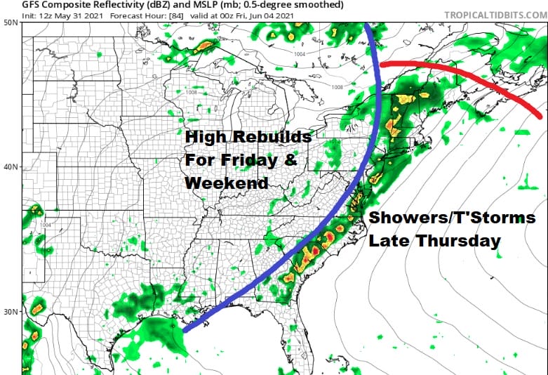
Once the front and trough pass and lift out the ridge along the East Coast rebuilds quickly but this time it rebuilds a little further west, inland of the coast. This is going to allow temperatures to warm considerably over the weekend and into next week. Friday sunshine returns with highs in the upper 70s and lower 80s and we will be into the 80s inland with no worse than partly sunny skies over the weekend and into next week as the ridge holds for awhile at least. Sea breezes will be localized and confined mainly to south shore areas in the afternoon and evening.
BE SURE TO DOWNLOAD THE FREE METEOROLOGIST JOE CIOFFI WEATHER APP &
ANGRY BEN’S FREE WEATHER APP “THE ANGRY WEATHERMAN!

MANY THANKS TO TROPICAL TIDBITS & F5 WEATHER FOR THE USE OF MAPS
Please note that with regards to any severe weather, tropical storms, or hurricanes, should a storm be threatening, please consult your local National Weather Service office or your local government officials about what action you should be taking to protect life and property.