July 4th Weekend Outlook Watching A Cold Front For Late Saturday
July 4th Weekend Outlook Watching A Cold Front For Late Saturday

July 4th Weekend Outlook Watching A Cold Front For Late Saturday
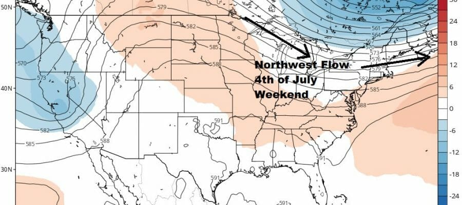
The pattern this week will not change much across the US and that is a promising development for the July 4th weekend. We been under a rather busy northwest flow from Canada for the last few weeks that seems to ebb and flow. When the jet stream moves to our south we get cold fronts ahead of that and dry air behind it. It seems we are setting up for a decent July 4th weekend. We will be warming up ahead of it late this week as another high goes to our south and we get into a very warm and humid southwest flow.

Friday getaway day looks to be a very warm and more humid type of day with highs reaching the mid to upper 80s. Saturday will be the one day where we will probably have to deal with showers and thunderstorms in the late afternoon and evening. We have a cold front coming through along with an upper trough. Saturday will be very warm to hot and humid with highs in the upper 80s to some lower 90s. There is enough energy here for the potential for stronger thunderstorms to develop so we will keep an eye on the prospects for severe weather.
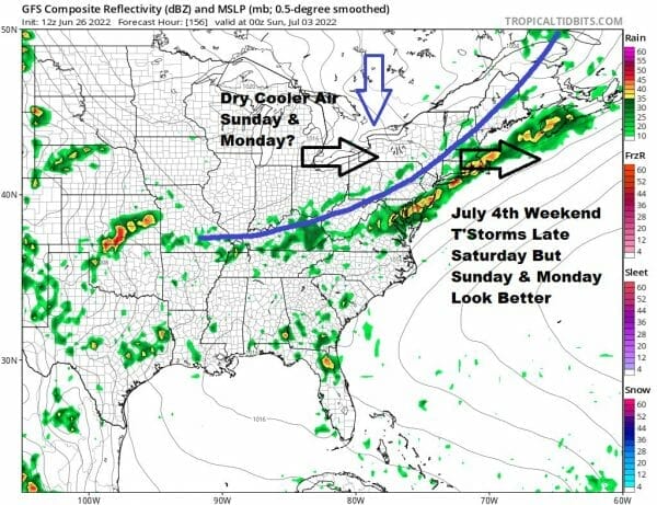
The one question for early Sunday is whether the front gets hung up for a short period of time. This would leave us with some early clouds but it would seem that the front should start moving again in short order and that even with early clouds, we should see some developing sunshine with highs in the 80s. Unless the front were to stall out for a longer period of time, we should be okay. As long as the upper air northwesterly winds strengthen enough we should be okay for Sunday. There is another cooler less humid air mass that will be dropping out of the Plains and heading to the east for Monday. This should leave us in sunshine with lower humidity and highs in the low to mid 80s. There is no blocking going on so we don’t need to worry about an ocean flow or any doom and gloom. For now most of Saturday should be fine except for late day thunderstorms. Most of Sunday should be okay except for some early clouds. Monday July 4th should be the best of the 3. That at least sums up an early look at the July 4th holiday weekend.
BE SURE TO DOWNLOAD THE FREE METEOROLOGIST JOE CIOFFI WEATHER APP &
ANGRY BEN’S FREE WEATHER APP “THE ANGRY WEATHERMAN!
MANY THANKS TO TROPICAL TIDBITS & F5 WEATHER FOR THE USE OF MAPS
Please note that with regards to any severe weather, tropical storms, or hurricanes, should a storm be threatening, please consult your local National Weather Service office or your local government officials about what action you should be taking to protect life and property.


