Jose Offshore Coastal Flooding Continues
Jose Offshore Coastal Flooding Continues
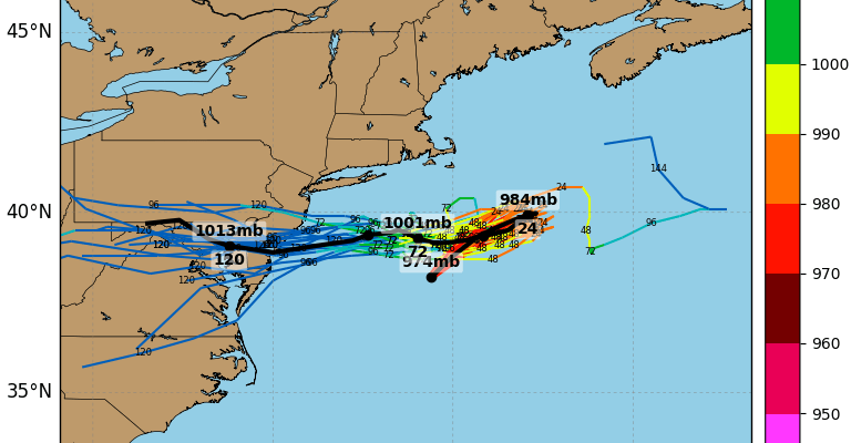
Tropical Storm Jose remains in our backyard and will remain in our back your for the next several days. Even though Jose has been sitting over relatively cooler water the structure of the tropical storm actually looks rather impressive this morning. It seems Jose wants to hold on as a tropical system for awhile longer. It is drifting to the northeast ever so slowly and very soon all models have Jose coming to a grinding halt and then beginning a track back to the west or southwest.
SATELLITE LOOP

Clouds from Jose are rotating back westward to just inland of the coast. We will be battling that today as areas from Western New Jersey westward into Pennsylvania enjoy a rather beautiful day of sunshine and temperatures in the 80s while areas to the east From NYC and Coastal New Jersey east to Long Island and Connecticut fight clouds all day. It is also still a bit breezy along the coast but nothing that is causing any issues.
..JOSE CONTINUES TO PRODUCE DANGEROUS SURF AND RIP CURRENTS ALONG
A LARGE PORTION OF THE U.S. EAST COAST…
SUMMARY OF 800 AM EDT…1200 UTC…INFORMATION
———————————————-
LOCATION…38.8N 70.2W
ABOUT 165 MI…265 KM S OF NANTUCKET MASSACHUSETTS
MAXIMUM SUSTAINED WINDS…65 MPH…100 KM/H
PRESENT MOVEMENT…NE OR 40 DEGREES AT 8 MPH…13 KM/H
MINIMUM CENTRAL PRESSURE…976 MB…28.82 INCHES
WATCHES AND WARNINGS
——————–
CHANGES WITH THIS ADVISORY:
None.
SUMMARY OF WATCHES AND WARNINGS IN EFFECT:
A Tropical Storm Warning is in effect for…
* Woods Hole to Sagamore Beach, including Cape Cod
* Block Island
* Martha’s Vineyard
* Nantucket
SATELLITE LOOP

REGIONAL RADAR

Most of the rain with Jose is well offshore. There are a few week little bands that occasionally have been popping up and sweeping back westward but these should be few and far between and confined to coastal locations.
LOCAL RADAR NEW YORK CITY

LOCAL RADAR PHILADELPHIA


Coastal flooding remains an issue for the next several days so the strength of Jose and what it does track wise will have an impact on the extent of any coastal flooding. Minor to occasionally moderate coastal flooding is indicated with tides running up to 2 feet above normal Today is the new moon so tides are already running high as it is. Coastal flooding could still be an issue this weekend.
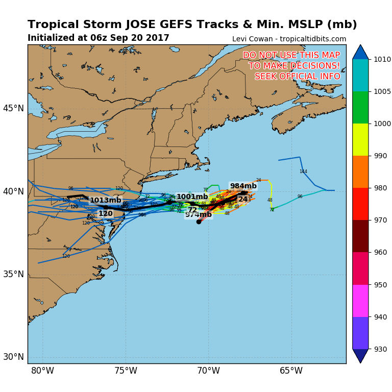
As far as weather conditions for Thursday and Friday most areas from NYC north, west, and south should see some sunshine however to the east with Jose offshore and possibly backing westward we will have to watch to see how far west clouds get and even some rain can’t be ruled out for later Thursday or Friday. Ultimately Jose’s west southwest motion may have an impact on Hurricane Maria and how it moves up the East Coast over the weekend and early next week. We will evaluate this later today but with so many players on the scene the uncertainly in the forecast for Hurricane Maria is very high.
FiOS1 News Weather Forecast For Long Island
FiOS1 News Weather Forecast For New Jersey
FiOS1 News Weather Forecast For Hudson Valley


