
Independence Day Sunshine Low Humidity
No Rain Forecast Through the Weekend
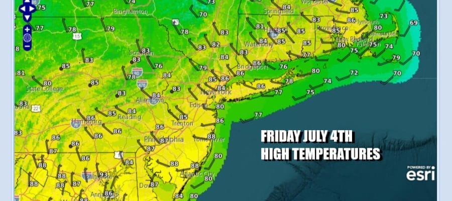
It is Independence Day and the start of a long holiday weekend. Many of you may be stretching this out to 4 days to include the weekend and Monday and why not! A cold front and upper trough have passed through and now we enjoy a day of northwest winds, sunshine, and temperatures that will be topping out in a range between 80 and 85 degrees. More importantly is dew points that will be in the 50s so it will be very comfortable. No showers or thunderstorms are forecast for the next few days. Tonight will be ideal for fireworks shows with mainly clear skies. Most lows will be in the 60s and humidity levels remain low.
SATELLITE WITH LIGHTNING STRIKES

WEATHER RADAR

We do not say any real complications for the weekend. The one thing we are watching is low pressure that is developing off the Southeast Coast of the US. We are seeing thunderstorms becoming more concentrated offshore and it is possible that we could see a tropical depression develop over the next 48 hours. For now most of the rain with this system is offshore but we expect to see the low track to the north or northwest at least initially. Heavy rains are possible in the Coastal Carolinas over the weekend.

While it is possible that we could see some of the moisture creep northward Sunday into Monday we expect that to be nothing more than some high clouds with all the rain staying to the south. In the meantime with high pressure sandwiched in between the coastal low to the south and a weather front to the north, we should remain dry and thunderstorm free through at least Sunday and possibly Monday.

Saturday we will see plenty of sunshine. Temperatures will be edging a bit higher to the middle and upper 80s. Dew points while nudging higher will remain below what I would consider to be uncomfortable. Dew points will likely inch up a bit on Sunday as will temperatures. As long as clouds from the south don’t get in the way, we will have enough sun to tak highs to the upper 80s with some hot spots getting close to 90.
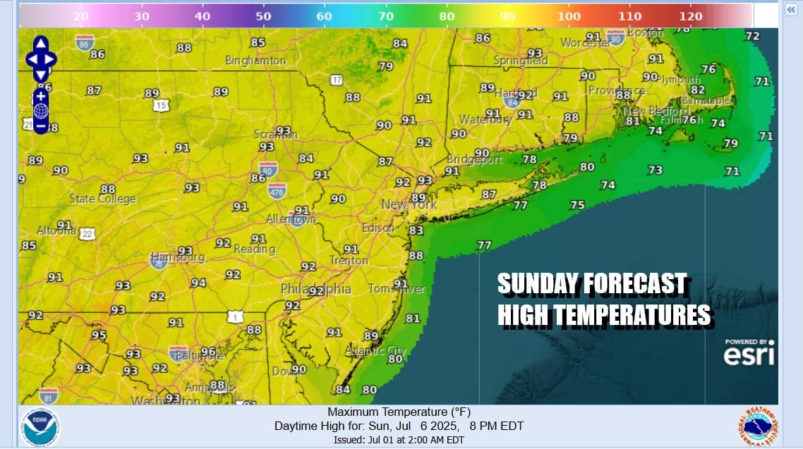
Monday will be very warm to hot and more humid with highs reaching the upper 80s and lower 90s. Some scattered thunderstorms are possible but we expect them to be mostly inland and they should be few and far between, Tuesday a cold front will drop southeastward from Upstate NY and that stands to produce a higher chance for thunderstorms late Tuesday as the front passes.
BE SURE TO DOWNLOAD THE FREE METEOROLOGIST JOE CIOFFI WEATHER APP &
ANGRY BEN’S FREE WEATHER APP “THE ANGRY WEATHERMAN!
MANY THANKS TO TROPICAL TIDBITS FOR THE USE OF MAPS
Please note that with regards to any severe weather, tropical storms, or hurricanes, should a storm be threatening, please consult your local National Weather Service office or your local government officials about what action you should be taking to protect life and property.


