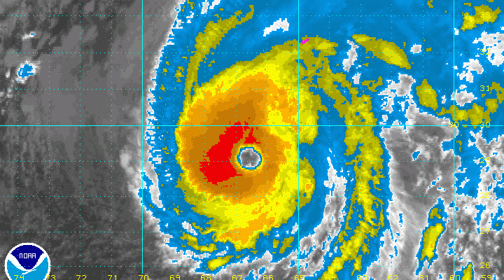
Hurricane Nicole 130 MPH Winds Bearing Down On Bermuda
Hurricane Nicole 130 MPH Winds Bearing Down On Bermuda

Hurricane Nicole 130 MPH Winds Bearing Down On Bermuda

Hurricane Nicole is bearing down on Bermuda. The hurricane is approaching category 4 status with maximum sustained winds now 130 mph and the lowest pressure of 950 mb which is a drop of 20 mb in the last 20 hours. Further strengthening is possible before the hurricane hits Bermuda with full force Wednesday morning. The eye is 30 miles wide and is forecast to move right over the island around noontime.
BULLETIN
HURRICANE NICOLE ADVISORY NUMBER  36...CORRECTED
NWS NATIONAL HURRICANE CENTER MIAMI FL       AL152016
1100 PM AST WED OCT 12 2016

CORRECTED FOR DIRECTION OF MOTION IN DISCUSSION SECTION

...EXTREMELY DANGEROUS CATEGORY FOUR NICOLE HEADING FOR BERMUDA...


SUMMARY OF 1100 PM AST...0300 UTC...INFORMATION
-----------------------------------------------
LOCATION...30.1N 66.4W
ABOUT 180 MI...290 KM SSW OF BERMUDA
MAXIMUM SUSTAINED WINDS...130 MPH...215 KM/H
PRESENT MOVEMENT...NNE OR 20 DEGREES AT 12 MPH...19 KM/H
MINIMUM CENTRAL PRESSURE...950 MB...28.06 INCHES


WATCHES AND WARNINGS
--------------------
CHANGES WITH THIS ADVISORY:

None.

SUMMARY OF WATCHES AND WARNINGS IN EFFECT:

A Hurricane Warning is in effect for...
* Bermuda

A Hurricane Warning means that hurricane conditions are expected
somewhere within the warning area. Preparations to protect life and
property should be rushed to completion.

For storm information specific to your area, please monitor
products issued by your national meteorological service.


DISCUSSION AND 48-HOUR OUTLOOK
------------------------------
At 1100 PM AST (0300 UTC), the large eye of Hurricane Nicole was
located near latitude 30.1 North, longitude 66.4 West. Nicole is
moving toward the north-northeast near 12 mph (19 km/h). An increase
in forward speed is expected Thursday, followed by a turn toward the
northeast and a further increase in forward speed expected by
Thursday night. On the forecast track, the core of Nicole will pass
over or near Bermuda on Thursday.

Data from an Air Force Reserve Hurricane Hunter aircraft indicate
that maximum sustained winds have increased to near 130 mph (215
km/h) with higher gusts. Nicole is an extremely dangerous category
4 hurricane on the Saffir-Simpson Hurricane Wind Scale. Little
change in strength is expected overnight, and Nicole is forecast to
be at major hurricane strength when it moves near Bermuda. Some
weakening is expected to begin by late Tuesday.

Nicole has a large area of hurricane-force winds that extend outward
up to 65 miles (100 km) from the center. Tropical-storm-force
winds extend outward up to 160 miles (260 km).

The latest estimated minimum central pressure from the aircraft is
950 mb (28.06 inches).


HAZARDS AFFECTING LAND
----------------------
WIND:  Hurricane conditions are expected to begin on Bermuda
Thursday morning, with tropical storm conditions expected to begin
soon.

STORM SURGE:  A dangerous storm surge will raise water levels by as
much as 6 to 8 feet above normal tide levels in Bermuda. The surge
will be accompanied by large and destructive waves.

RAINFALL:  Nicole is expected to produce total rain accumulations
of 4 to 8 inches over Bermuda through Thursday.

SURF:  Swells associated with Nicole will affect Bermuda during the
next few days, and will spread northward along the United States
east coast from the Carolinas northward through the next few days.
These swells will create dangerous surf conditions and rip currents.
Please refer to products being issued by your local weather office
for more information.

TORNADOES:  Isolated tornadoes are possible on Bermuda tonight and
early Thursday.
WINTER 2016-2017 PART 1 OCEAN WATER TEMPERATURES
WINTER 2016-2017 PART 2 ARCTIC SEA ICE AND SIBERIAN SNOW COVER
WINTER 2016-2017 PART 3 NEW JERSEY PREVIEW
WINTER 2016-2017 PART 4 EASTERN PENNSYLVANIA PREVIEW
FiOS1 News Weather Forecast For Long Island
FiOS1 News Weather Forecast For New Jersey
FiOS1 News Weather Forecast For Hudson Valley
NATIONAL WEATHER SERVICE SNOW FORECASTS
LATEST JOESTRADAMUS ON THE LONG RANGE
Weather App

Don’t be without Meteorologist Joe Cioffi’s weather app. It is really a meteorologist app because you get my forecasts and my analysis and not some automated computer generated forecast based on the GFS model. This is why your app forecast changes every 6 hours. It is model driven with no human input at all. It gives you an icon, a temperature and no insight whatsoever.
It is a complete weather app to suit your forecast needs. All the weather information you need is right on your phone. Android or I-phone, use it to keep track of all the latest weather information and forecasts. This weather app is also free of advertising so you don’t have to worry about security issues with your device. An accurate forecast and no worries that your device is being compromised.
Use it in conjunction with my website and my facebook and twitter and you have complete weather coverage of all the latest weather and the long range outlook. The website has been redone and upgraded. Its easy to use and everything is archived so you can see how well Joe does or doesn’t do when it comes to forecasts and outlooks.
Just click on the google play button or the apple store button on the sidebar for my app which is on My Weather Concierge. Download the app for free. Subscribe to my forecasts on an ad free environment for just 99 cents a month.
Get my forecasts in the palm of your hand for less than the cost of a cup of Joe!
![]()
![]()