Hurricane Lane Winds 130 MPH Moving Westward 16 MPH
UPPER RIDGE NORTH OF HAWAII HOLDS KEY TO LONG RANGE FORECAST
Hurricane Lane is holding its own as a major hurricane. The eye which had all but disappeared yesterday is making a comeback today and the the hurricane remains a well organized tropical system. Weather models have become more muddled in the last 24 hours showing a larger spread of possibilities regarding Lane. Some of the hurricane tracking models are bringing Lane very close to Hawaii later this week. It appears that the ridge to the north of Hawaii will hold the key to where Lane goes and if there will be land impacts to the Hawaiian Islands.
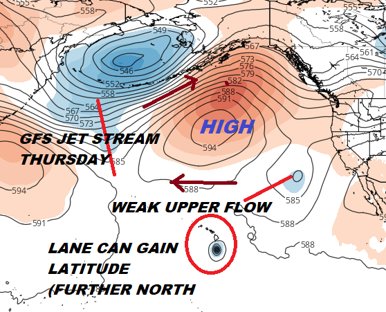
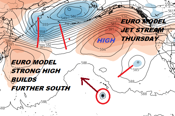
The big issue is the upper high to the north. The problem is that unlike in the case of Hurricane Hector 2 weeks ago, the high is further north. There are also troughs on either side which is creating a weakness in between. Lane would be able to gain some latitude here (move further north) before it hits that upper high and whatever is left of it is deflected back to the west. The European model which is the furthest south of the weather models today handles this a bit differently.
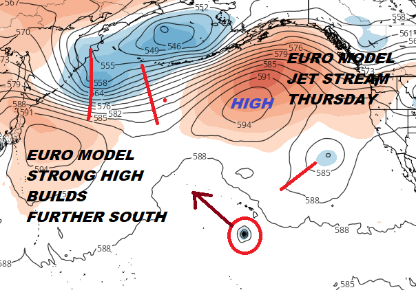
The European model has the upper high in the middle of the Pacific a little further south than the GFS model. This creates less of a weakness for Hurricane Lane to respond to. The European keeps Lane well south of the Hawaiian Islands with little impact. We will need to resolve the issue of the ridge to the north which will determine the track. The GFS model steering actually collapses with Lane nearing the islands making for more uncertainty.
HURRICANE LANE SATELLITE

The other question is what exactly will we have left regarding Lane at this point. Colder sea surface temperatures and persistent wind shear suggest weakening as Lane nears the Islands, if it does. How strong will or won’t Lane be will be an even larger question going forward. Hawaii has a history of seeing major hurricane fall apart before reaching the islands. Needless to say that the uncertainty here is high.

The official Central Pacific Hurricane Center forecast keeps Hurricane Lane well south of the big island of Hawaii in its official forecast by well over 200 miles. They do note in their discussion that the uncertainty level is high given the parameters. You can read more on Lane by visiting the Central Pacific Hurricane Center.
We will be livestreaming at 8pm Eastern Time Sunday August 18, 2018 on Hurricane Lane as well as the weather this week across the Northeast, Middle Atlantic States and elsewhere in the US.
THANKS TO TROPICAL TIDBITS FOR THE USE OF MAPS
Please consult your local National Weather Service office at weather.gov for the latest information on any tropical or storms or hurricanes that could be a threat to your area. Consult your local government officials regarding action you may need to take to secure life and property
FiOS1 News Weather Forecast For Long Island
FiOS1 News Weather Forecast For New Jersey
FiOS1 News Weather Forecast For Hudson Valley