Hurricane Ida Strengthening Rapidily, Marching Toward Louisiana Late Sunday Landfall

Weather in 5/Joe & Joe Weather Show Latest Podcast
Hurricane Ida Strengthening Rapidly, Marching Toward Louisiana Late Sunday Landfall
Hurricane Ida is on a steady march northwestward and the latest satellite loops and recon reports show that Ida is strengthening rapidly. The satellite loop shows the eye forming and the storm is becoming more symmetrical in structure. Pressures have fallen 11 millibars in the 5 hours which indicates rapid strengthening has begin. Conditions remain favorable for rapid strengthening into Sunday morning so we will soon see just how strong Ida will get before closing in on the Louisiana coast late Sunday afternoon and night.
SATELLITE

IDA INTENSIFYING OVER THE GULF OF MEXICO…
…PREPARATIONS TO PROTECT LIFE AND PROPERTY SHOULD BE RUSHED TO
COMPLETION TODAY IN THE WARNING AREA ALONG THE NORTHERN GULF
COAST…
SUMMARY OF 100 PM CDT…1800 UTC…INFORMATION
———————————————-
LOCATION…25.5N 86.6W
ABOUT 290 MI…470 KM SSE OF THE MOUTH OF THE MISSISSIPPI RIVER
ABOUT 380 MI…610 KM SE OF HOUMA LOUISIANA
MAXIMUM SUSTAINED WINDS…100 MPH…155 KM/H
PRESENT MOVEMENT…NW OR 315 DEGREES AT 16 MPH…26 KM/H
MINIMUM CENTRAL PRESSURE…976 MB…28.82 INCHES
WATCHES AND WARNINGS
——————–
CHANGES WITH THIS ADVISORY:
The Tropical Storm Warning has been extended eastward along the
northern Gulf coast to the Alabama/Florida border.
The Hurricane Watch along the coast of Mississippi from the Mouth
of the Pearl River to the Mississippi/Alabama border has been
discontinued. The Hurricane Watch along the coast of Louisiana
west of Intracoastal City has also been discontinued.
The Storm Surge Watch from Sabine Pass to Rockefeller Wildlife
Refuge, Louisiana has been discontinued.
SUMMARY OF WATCHES AND WARNINGS IN EFFECT:
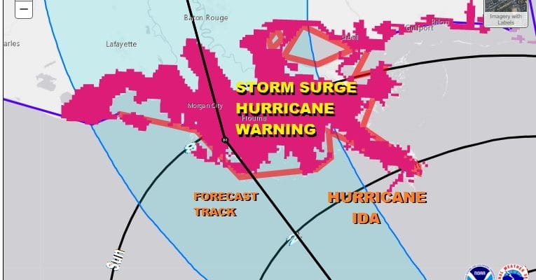
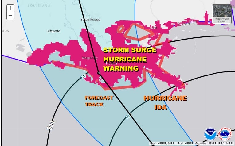
A Storm Surge Warning is in effect for…
* East of Rockefeller Wildlife Refuge Louisiana to the
Mississippi/Alabama border
* Vermilion Bay, Lake Borgne, Lake Pontchartrain, and Lake Maurepas
A Hurricane Warning is in effect for…
* Intracoastal City Louisiana to the Mouth of the Pearl River
* Lake Pontchartrain, Lake Maurepas, and Metropolitan New Orleans
A Storm Surge Watch is in effect for…
* Mobile Bay
A Tropical Storm Warning is in effect for…
* Cameron Louisiana to west of Intracoastal City Louisiana
* Mouth of the Pearl River to the Alabama/Florida border
Some adjustments have been made for areas to the east and west of the storm track adding tropical storm warnings on both sides and removing the hurricane watch for the Mississippi and Alabama coast.
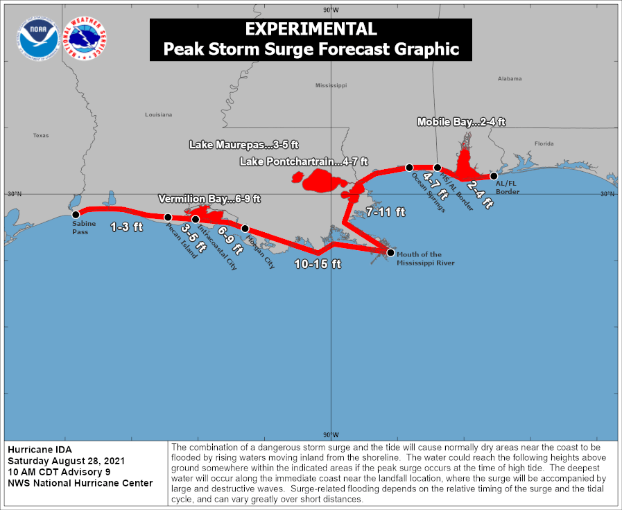
Landfall is anticipated to occur Sunday evening with the track position on the map for 7pm Central Time. If Ida makes landfall as a major hurricane the storm surge on the east side of the track will be quite high. 7 to 11 feet of storm surge is forecast in Southeast Louisiana to the southeast of New Orleans.
Once inland the attention will shift to the heavy rains of 10 inches or more that will spread northward from Louisiana into the Tennessee Valley Monday and eventually we could see soaking rains in parts of the Mid Atlantic and Northeast Wednesday.
BE SURE TO DOWNLOAD THE FREE METEOROLOGIST JOE CIOFFI WEATHER APP &
ANGRY BEN’S FREE WEATHER APP “THE ANGRY WEATHERMAN!

MANY THANKS TO TROPICAL TIDBITS & F5 WEATHER FOR THE USE OF MAPS
Please note that with regards to any severe weather, tropical storms, or hurricanes, should a storm be threatening, please consult your local National Weather Service office or your local government officials about what action you should be taking to protect life and property.