Hurricane Hector 130 MPH WINDS Heads West Tropical Storm Watch Big Island of Hawaii
Hurricane Hector 130 MPH WINDS Heads West
Tropical Storm Watch Big Island of Hawaii
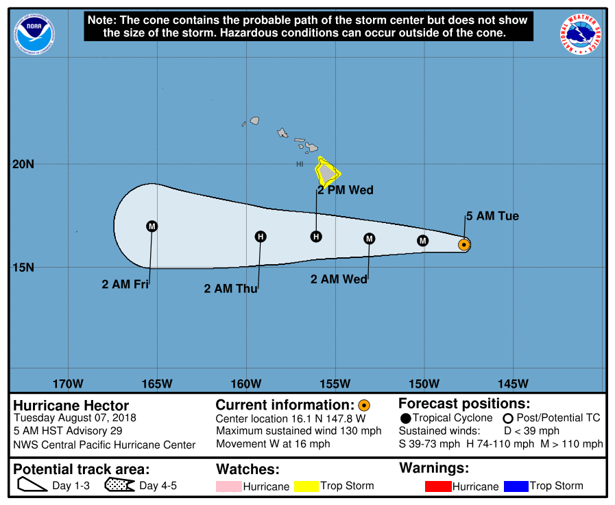
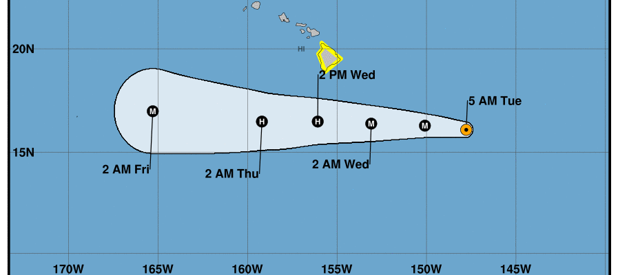
Hurricane Hector has weakened somewhat from its peak winds of 155 mph last night. It is still a formidable Category 4 hurricane with winds of 130 mph. Hector has a well formed eye and seems to still be gaining some northern latitude this afternoon. However a turn to the west is due to happen soon and Hurricane Hector should still pass well south of the Hawaiian Islands. The Big Island of Hawaii lies further south than any of the other islands. It may experience the closest call of all the islands with eye passing about 120-150 miles south of the southernmost tip of the big island on Wednesday.
HURRICANE HECTOR SATELLITE

Here is the latest advisory from the Central Pacific Hurricane Center
...MAJOR HURRICANE HECTOR STEADILY MARCHING WESTWARD TO THE
EAST-SOUTHEAST OF HAWAII...


SUMMARY OF 800 AM HST...1800 UTC...INFORMATION
----------------------------------------------
LOCATION...16.3N 148.5W
ABOUT 495 MI...795 KM ESE OF HILO HAWAII
ABOUT 705 MI...1135 KM ESE OF HONOLULU HAWAII
MAXIMUM SUSTAINED WINDS...130 MPH...215 KM/H
PRESENT MOVEMENT...W OR 280 DEGREES AT 16 MPH...26 KM/H
MINIMUM CENTRAL PRESSURE...947 MB...27.97 INCHES


WATCHES AND WARNINGS
--------------------
CHANGES WITH THIS ADVISORY:

None.

SUMMARY OF WATCHES AND WARNINGS IN EFFECT:

A Tropical Storm Watch is in effect for...
* Hawaii County

A Tropical Storm Watch means that tropical storm conditions are
possible within the watch area within 48 hours.

Interests elsewhere in the Hawaiian Islands should monitor the
progress of Hector.

For storm information specific to your area, please monitor
products issued by the National Weather Service office in
Honolulu Hawaii.


DISCUSSION AND OUTLOOK
----------------------
At 800 AM HST (1800 UTC), the eye of Hurricane Hector was located
near latitude 16.3 North, longitude 148.5 West. Hector is moving
toward the west near 16 mph (26 km/h). This general motion is
expected to continue through Thursday. On the forecast track, the
center of Hector is expected to pass less than 200 miles south of
the Big Island on Wednesday. Remember, the effects of a hurricane
are far-reaching and can extend well away from the center.

Maximum sustained winds are near 130 mph (215 km/h) with higher
gusts.  Hector is a category 4 hurricane on the Saffir-Simpson
Hurricane Wind Scale. Some weakening is forecast during the next 48
hours.

Hurricane-force winds extend outward up to 30 miles (45 km) from
the center and tropical-storm-force winds extend outward up to 90
miles (150 km).

The estimated minimum central pressure is 947 mb (27.97 inches).


HAZARDS AFFECTING LAND
----------------------
SURF:  Swells generated by Hector are expected to reach southeast
and east facing shores of the Big Island and eastern Maui late
today, likely becoming large and dangerous by late tonight and
Wednesday.

WIND:  Tropical storm force winds are possible across Hawaii
County late tonight and Wednesday.
Please consult your local National Weather Service office at weather.gov for the latest information on any tropical or storms or hurricanes that could be a threat to your area. Consult your local government officials regarding action you may need to take to secure life and property
FiOS1 News Weather Forecast For Long Island
FiOS1 News Weather Forecast For New Jersey
FiOS1 News Weather Forecast For Hudson Valley