
HRRR Model Saturday View

MENTION JOE CIOFFI AND GET A 5% DISCOUNT
HRRR MODEL SATURDAY VIEW WINTER WEATHER ADVISORY
HUNTERDON & MERCER COUNTIES IN NEW JERSEY
I thought we would take an HRRR Model Saturday view of things. The HRRR model is an ultra short range model that runs every hour and has been pretty good at guiding forecasters once we hit the ultra short term. This way in the morning we can compare how the model has changed and if there are any noticeable short term trends. The radar forecast view is for 7pm Saturday evening which shows precipitation continuing over much of the area including much of Central New Jersey to New York City & Long Island.
HRRR Model Saturday View Radar 7pm Saturday
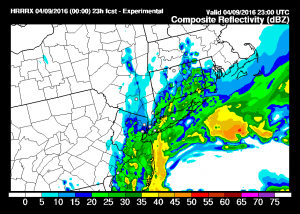
HRRR Model Saturday View Precipitation & Surface Map Saturday Evening 7pm

The second map is the total accumulated precipitation through 7pm Saturday. The heaviest amounts are in Central and Southern New Jersey and parts of Western Long Island to about New York City. The model seems to match up with the last two runs of the NAM model. The northern extent of the precipitation is limited just inland and north of the coast.
HRRR Model Saturday View Total Snowfall Through 7pm Saturday
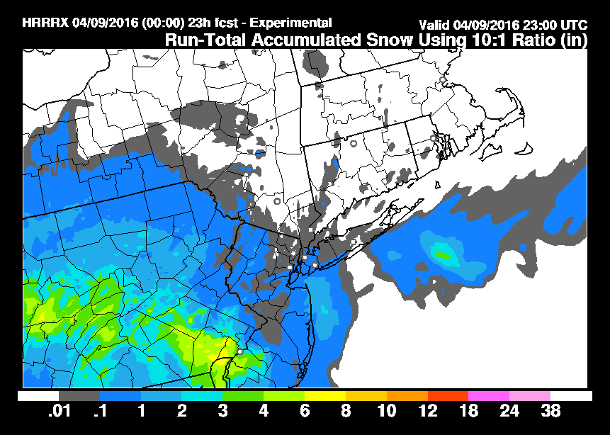
As far as accumulated snow is concerned the HRRR model is not particularly bullish for snow through 7pm showing trace amounts to an inch in most places. Southeastern Pennsylvania and extreme Southwest New Jersey seem to get the most with an area of 3 to 6 inch amounts being indicated. Given the radar presentation it would seem that for areas north and east that there will be several more hours of rain or snow before the precipitation pulls away to the east. Now we will wait and see how this changes later this morning as this all gets underway.
FiOS1 News Weather Forecast For Long Island
FiOS1 News Weather Forecast For New Jersey
FiOS1 News Weather Forecast For Hudson Valley
NATIONAL WEATHER SERVICE SNOW FORECASTS
LATEST JOESTRADAMUS ON THE LONG RANGE

NOMINATED FOR AN APPY AWARD FOR BEST WEATHER APP!!
Weather App

Don’t be without Meteorologist Joe Cioffi’s weather app. It is really a meteorologist app because you get my forecasts and my analysis and not some automated computer generated forecast based on the GFS model. This is why your app forecast changes every 6 hours. It is model driven with no human input at all. It gives you an icon, a temperature and no insight whatsoever.
It is a complete weather app to suit your forecast needs. All the weather information you need is right on your phone. Android or I-phone, use it to keep track of all the latest weather information and forecasts. This weather app is also free of advertising so you don’t have to worry about security issues with your device. An accurate forecast and no worries that your device is being compromised.
Use it in conjunction with my website and my facebook and twitter and you have complete weather coverage of all the latest weather and the long range outlook. The website has been redone and upgraded. Its easy to use and everything is archived so you can see how well Joe does or doesn’t do when it comes to forecasts and outlooks.
Just click on the google play button or the apple store button on the sidebar for my app which is on My Weather Concierge. Download the app for free. Subscribe to my forecasts on an ad free environment for just 99 cents a month.
Get my forecasts in the palm of your hand for less than the cost of a cup of Joe!
![]()


