
Hot Weather Humidity & Passing Downpours
Hot Weather Humidity & Passing Downpours
Hot weather is headed to the East beginning Sunday but we do need a day of transition and Saturday will be that day. Low pressure off the New England coast made for a nice dry warm Friday with highs reaching into the 80s just about everywhere including the coast. A gusty northwest wind kept the sea breeze at bay except for perhaps right on the beaches late in the afternoon. Now we wait for a warm front to move through on Saturday.
I see two chances for SCATTERED downpours. One during the morning hours around or just after daybreak with a mix of sun and clouds to follow. Then a second chance for downpours or a thunderstorm late Saturday afternoon and evening. Again these will be scattered in nature. Temperatures will rise into the middle and even upper 80s away from the shore while along the immediate coast it will be upper 70s to lower 80s.
HOT WEATHER SUNDAY 2PM TEMPERATURES
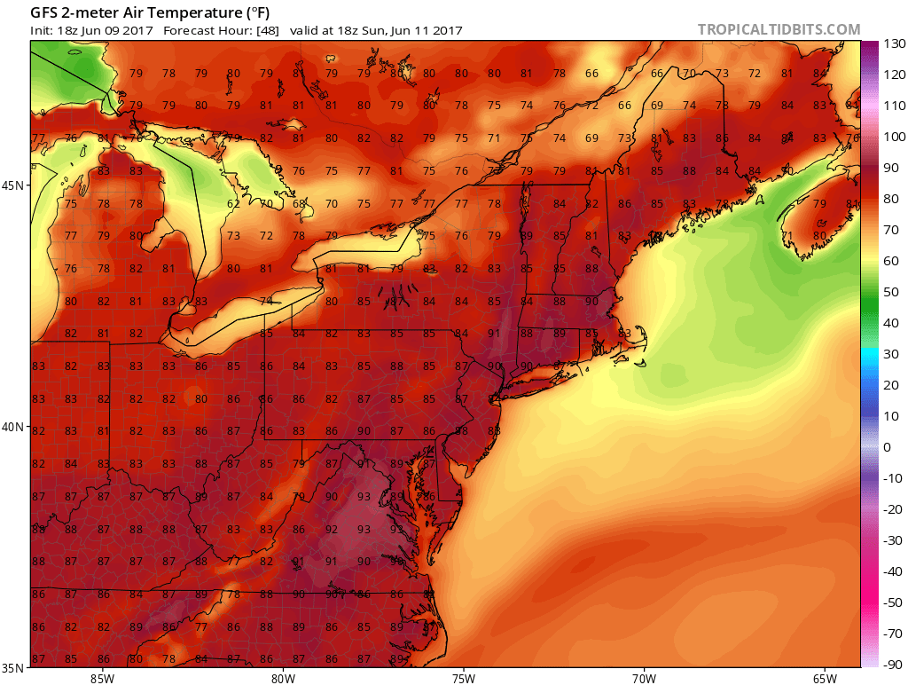
Once the west wind takes over this sets us up for hot weather Sunday. However the humidity Sunday will not be that high. Highs will reach the upper 80s to lower 90s with a few places pushing perhaps toward 93 or 94. No thunderstorms or showers are forecast for Sunday. It should be a great beach day so be sure to have the sun block handy.
SATELLITE LOOP

REGIONAL RADAR

LOCAL RADAR NEW YORK CITY

LOCAL RADAR PHILADELPHIA


Humdity does start to come up a bit on Monday and even more on Tuesday. The back door front will push through Tuesday evening so there could be some showers and thunderstorms with that. Temperatures both Monday and Tuesday will reach 90 to 95 in most areas. Once the front drops south Wednesday and Thursday will be cooler by at least 10-15 degrees with highs in the 70s to some lower 80s and a fresh wind from off the ocean.
As far as the long range goes we see the pattern keeping it from getting hot for more than a day or two at most and nothing extreme is expected. JOESTRADAMUS has more on the long range including a look at the tropics.
 GET JOE A CIGAR IF YOU LIKE

LANDSCAPE COMPANIES FOR YOUR NEEDS
LONG ISLAND ROCKLAND COUNTY Connecticut

![]()

ROCKLAND COUNTY TRI STATE SNOW REMOVAL JOHNSTOWN PA


FiOS1 News Weather Forecast For Long Island
FiOS1 News Weather Forecast For New Jersey
FiOS1 News Weather Forecast For Hudson Valley
NATIONAL WEATHER SERVICE SNOW FORECASTS
LATEST JOESTRADAMUS ON THE LONG RANGE
Weather App

Don’t be without Meteorologist Joe Cioffi’s weather app. It is really a meteorologist app because you get my forecasts and my analysis and not some automated computer generated forecast based on the GFS model. This is why your app forecast changes every 6 hours. It is model driven with no human input at all. It gives you an icon, a temperature and no insight whatsoever.
It is a complete weather app to suit your forecast needs. All the weather information you need is right on your phone. Android or I-phone, use it to keep track of all the latest weather information and forecasts. This weather app is also free of advertising so you don’t have to worry about security issues with your device. An accurate forecast and no worries that your device is being compromised.
Use it in conjunction with my website and my facebook and twitter and you have complete weather coverage of all the latest weather and the long range outlook. The website has been redone and upgraded. Its easy to use and everything is archived so you can see how well Joe does or doesn’t do when it comes to forecasts and outlooks.
Just click on the google play button or the apple store button on the sidebar for my app which is on My Weather Concierge. Download the app for free. Subscribe to my forecasts on an ad free environment for just 99 cents a month.
Get my forecasts in the palm of your hand for less than the cost of a cup of Joe!