
Higher Humidity Showery Rains Thunderstorms Severe Weather Risk
Tuesday Begins Delightful September-ish Weather

Higher Humidity Showery Rains Thunderstorms Severe Weather Risk
Tuesday Begins Delightful September-ish Weather

The weekend begins with Hurricane Ernesto which made landfall on Bermuda at 6am Saturday. This is the 4th hurricane in the last 10 years to landfall on the island. This is remarkable when you consider that Bermuda is about the size of Manhattan Island. We also have an upper trough and cold front coming in from the west. This trough and front extend from the Great Lakes to the Deep South and it will take 3 days for this system to play through the Eastern US. It will be worth the wait because what follows is a delightful air mass that will bring early September like conditions Tuesday through Friday.
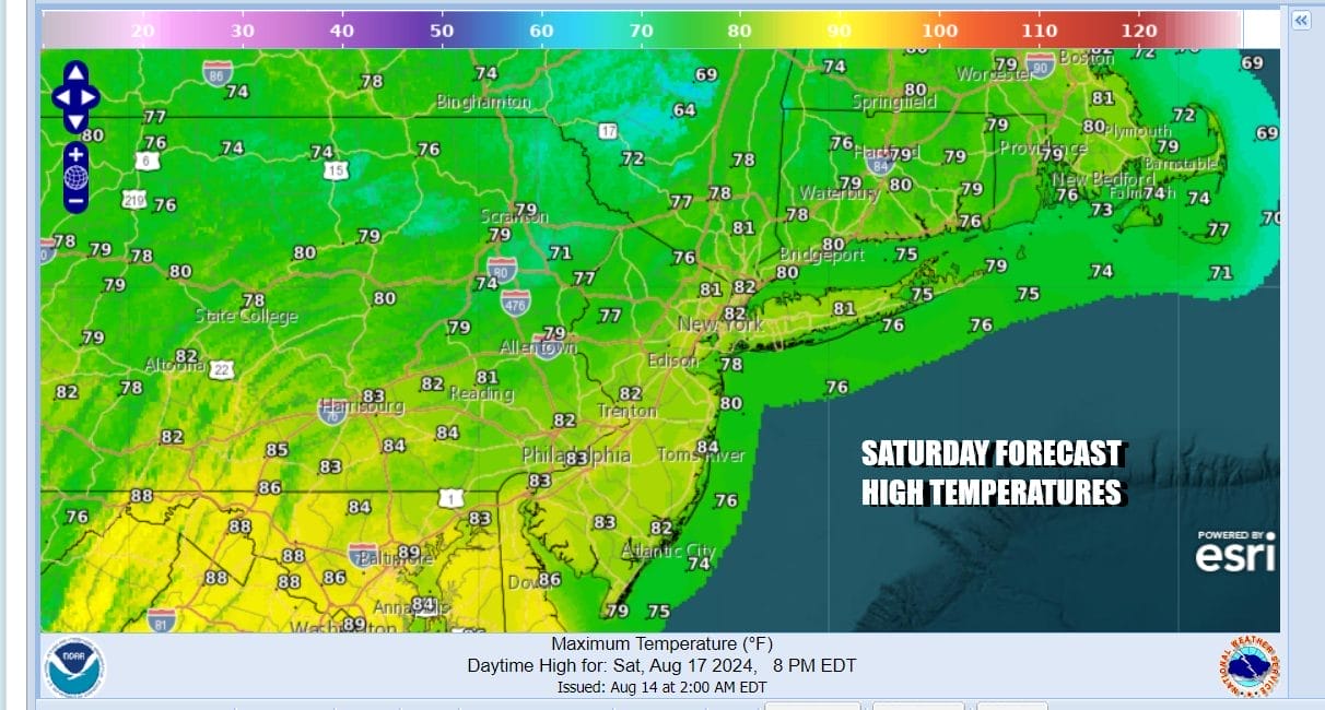
First off we have today and the humidity is noticeably higher. A warm front is moving through and some areas had showery rains overnight and this morning. The rest of the day we will see clouds with breaks of sunshine but there could be some afternoon and evening showery rains and thunderstorms. These storms will be spread out so not everyone will see them and the best chances will be for areas inland. Highs this afternoon will be generally in the upper 70s and lower 80s.
SATELLITE WITH LIGHTNING STRIKES

WEATHER RADAR

Hurricane Ernesto will be slowly moving northward tonight and Sunday away from Bermuda and then turning northeastward. Until Ernesto moves out of the way, the next trough and cold front can’t clear the coast and that leaves us in a bit of a precarious position weather-wise for Sunday. There will be some patchy areas of showery rains overnight into early Sunday morning. Then Sunday afternoon more numerous showers and thunderstorms are likely to develop.
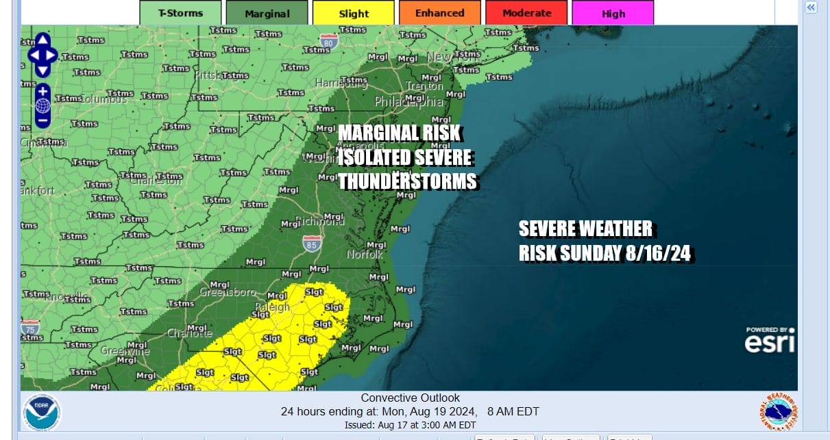
The Storm Prediction Center has indicated a marginal risk for severe weather which means isolated severe thunderstorms are possible. Some of these thunderstorms will produce heavy rain and are likely to be slow moving thanks to the crawling cold front so we may have some localized flash flooding to deal with. Again the risks are likely higher inland verses the coast.

Sunday highs will reach the upper 70s and lower 80s again and the humidity will remain high. Look for showery rains to continue on and off Sunday night and we will do it one more time Monday with the risk for showers and thunderstorms. Monday highs will be in the upper 70s and lower 80s again.

Finally the cold front will be able to clear the coast Monday night and this opens the door to a big payoff. Behind the front we have a large Canadian high that will be building into the Great Lakes and this high is bringing down not only very dry air into the Eastern US, but it is rather cool air for this time of year as well. Dew points will be dropping into the 50s and 40s beginning Tuesday and lasting through at least Friday of next week. Tuesday begins a stretch of days where we will sunshine and highs just in the 70s by day. By night skies will be clear and it will be cool with lows in the 50s inland and upper 50s and lower 60s along the coast and in warmer urban areas. You really can’t ask for better weather for the second half of August.
BE SURE TO DOWNLOAD THE FREE METEOROLOGIST JOE CIOFFI WEATHER APP &
ANGRY BEN’S FREE WEATHER APP “THE ANGRY WEATHERMAN!
MANY THANKS TO TROPICAL TIDBITS FOR THE USE OF MAPS
Please note that with regards to any severe weather, tropical storms, or hurricanes, should a storm be threatening, please consult your local National Weather Service office or your local government officials about what action you should be taking to protect life and property.
(Amazon is an affilate of Meteorologist Joe Cioffi & earns commissions on sales.)


