Heavy Rain Thunderstorms Monday Morning Commute
Heavy Rain Thunderstorms Monday Morning Commute
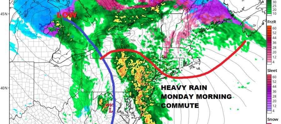
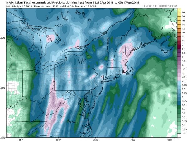
The map above of the HRRR model shows what the radar is going to look like at 8am Monday so clearly the morning commute is not going to be a fun one especially from NYC south. Heavy rain and thunderstorms will be going on though severe weather is depicted off the Virginia North Carolina coast so at least we won’t have to worry too much about out of control thunderstorms. However there will be 2 inches plus rainfall out of this in many areas so some street flooding is likely in the usual suspect areas.
NAM MODEL FORECAST RAINFALL
Meanwhile tonight the miserable weather continues with a cold rain and a persistent strong east wind from off the ocean that has created coastal flooding issues. The current surface map below shows that temperatures have actually gotten colder this evening with temperatures that have fallen into the 30s though they do all remain above freezing except in the Catskills.
Coastal Flood Warnings are up for much of the New Jersey coast with coastal flood advisories filling in the gaps from Long Island southward to Delaware. Flash Flood Watch is posted for much of New Jersey except the southern counties, Eastern Pennsylvania northward to just north of Route 80, and the Hudson Valley Orange & Sullivan counties. Much of the rain tonight will be on the light side but steady before the heavy rain gets underway late tonight.
US SATELLITE
REGIONAL RADAR
The midwest storm system remains impressive with the local radar showing the developing line of severe weather tonight across Western Virginia and Western North Carolina. Tornado watches are posted for those areas. That rain is destined to shift eastward and northeastward overnight.
LOCAL RADAR NEW YORK CITY
LOCAL RADAR PHILADELPHIA

As the front swings eastward Monday morning we will begin to see improvement from west to east though it will be slow. Downpours and thunderstorms could continue from NYC eastward until early Monday afternoon. Temperatures will hold where they are for awhile tonight before beginning to rise from south to north. We should be in the 50s north of NYC monday midday and 60s to the south. We should begin to clear out late in the day. Tuesday looks much better though chilly with some sunshine and highs just in the 50s.
 GET JOE A CIGAR IF YOU LIKE
FiOS1 News Weather Forecast For Long Island
FiOS1 News Weather Forecast For New Jersey
FiOS1 News Weather Forecast For Hudson Valley


