Heatwave Day 2 Highs Low to Mid 90s Severe Weather Risk Thursday
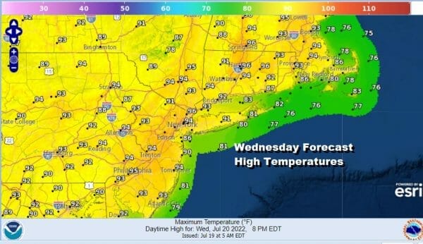
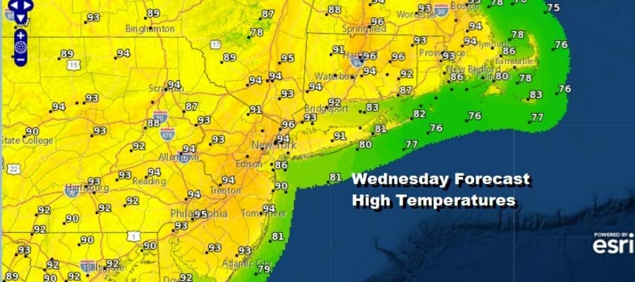
The second day of this heatwave will take temperatures a few degrees higher than yesterday and you can thank the launching pad this morning. Lows were in the mid to upper 70s. This will be day 2 of our heatwave. We are likely at least to get to 6 days by the time we reach Sunday. Today’s highs with lots of sunshine will reach the low and middle 90s. There isn’t much happening on the satellite or on the radars today and other than an isolated shower or thunderstorm (and we do mean isolated) 99.9% of you will be rain free. Heat advisories are posted which means that you are officially being advised that it is hot.
SATELLITE

WEATHER RADAR

Humidity levels are high and will remain high through Thursday. Thursday morning lows will be in the 70s to near 80 degrees so that sets the launching pad up for blastoff. Sunshine Thursday will take highs again into the low and middle 90s. Temperatures might be a little cooler at local beaches but not much cooler.

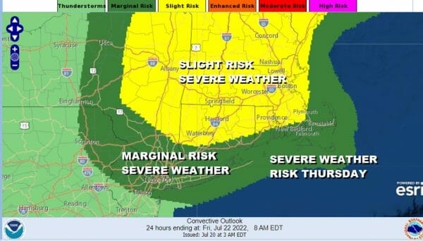
We do have a weather front that will be approaching and moving through. An upper trough will be moving across Southeastern Canada and this combination will trigger some thunderstorms and the risk for severe weather. Marginal risk covers Northern New Jersey to the Hudson Valley, NYC and Long Island with a slight risk for almost all of New England.
After this weather front passes it is back to hot weather. Cool air from the upper trough and cold front will remain in Canada this time around so Friday it will be a sunny hot and humid day. Technically the dew points Friday could be a little lower but not really enough to make a big difference. Friday highs will be in the low to mid 90s.

As far as the weekend is concerned, the heat continues with sunshine and high humidity for both Saturday and Sunday. Highs will be in the low to middle 90s. Another weather front will approach late Sunday and that will produce some showers and thunderstorms and there is some severe weather risk with that front. This front is likley to produce some temperature and humidity relief early next week.
BE SURE TO DOWNLOAD THE FREE METEOROLOGIST JOE CIOFFI WEATHER APP &
ANGRY BEN’S FREE WEATHER APP “THE ANGRY WEATHERMAN!
MANY THANKS TO TROPICAL TIDBITS & F5 WEATHER FOR THE USE OF MAPS
Please note that with regards to any severe weather, tropical storms, or hurricanes, should a storm be threatening, please consult your local National Weather Service office or your local government officials about what action you should be taking to protect life and property.


