
Heatwave Could Last 7 Days Across Much of the Northeast & Middle Atlantic

Heatwave Could Last 7 Days Across Much of the Northeast & Middle Atlantic
Friday begins what could be one of the longer stretches of heat and humidity we have seen in quite some time. For much of June we have been dealing with a trough in the Eastern US and a jet stream connection from Canada which has been bringing down some nice pleasant air masses from time to time. That has changed as we now have an upper high that is building in the Northeast and it will be sitting right overhead. This is a set up where we do get extreme temperatures and that could be the case on Sunday which I believe will be the hottest of the next 3 days.
FRIDAY FORECAST HIGH TEMPERATURES
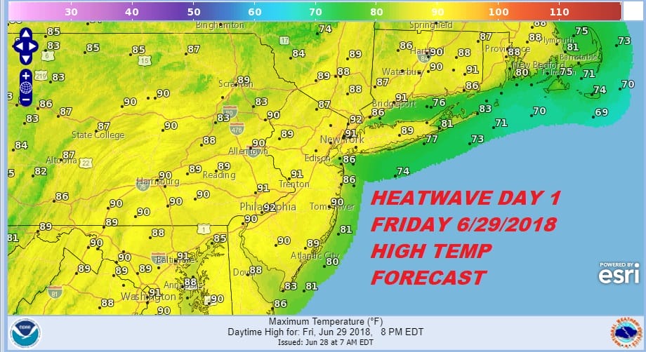
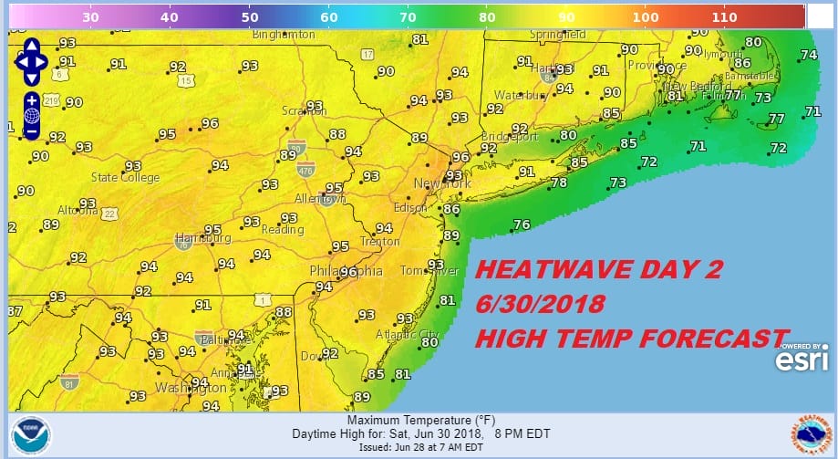
Friday will be day one for most but not all areas. Certainly areas inland from NYC north, west, and southwest should reach 90 or better while areas to the east see upper 80s to near 90. Saturday brings in almost everyone into the land of 90 degrees plus and low to middle 90s will be common place.
SATURDAY FORECAST HIGH TEMPERATURES
Beginning today and into Sunday a strong upper high builds across the Northeast and it will be parked literally right overhead. This is as opposite a jets stream pattern as you can get from where we were a few days ago. The flow from Canada is completely cut off. Sinking air prevents any kind of thunderstorm activity. Even pop ups will be few and far between if any at all. A west or a west northwest surface wind will be in play so everything points to a heatwave here.
GFS UPPER AIR FORECAST SUNDAY JULY 1, 2018
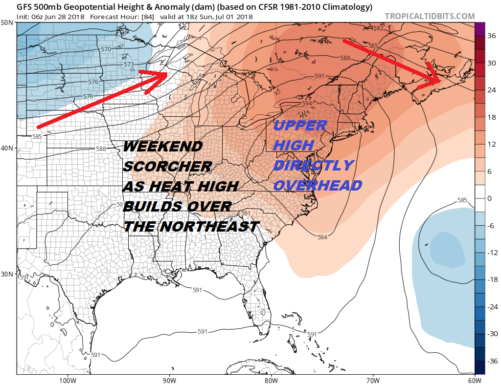
The table is set for highs in the middle to upper 90s Sunday and I would not at all be surprised to see somebody hit 100 degrees. The GFS model seems to lean to the idea of 100 degree readings extending from the Middle Atlantic States northeastward to Massachusetts.

It is likely that the extreme numbers here are overdone but certainly highs in the mid to upper 90s are possible and that is close enough to 100 degrees. It would not at all be a surprise to me if a few spots get there. After Sunday we will start to ease from the extreme temperatures as the upper high starts to weaken and flatten out. 90s should still be reached Monday through at least Wednesday. We could start to see some pop up thunderstorms Monday afternoon with perhaps a better chance for them Tuesday and Wednesday. No other important developments are on the table as far as the weather pattern is concerned. It is just summer heat and humidity going forward.
We do have some thunderstorms to deal with today before the heat gets here and JOESTRADAMUS has more from this post this morning.
Last night on the JOE & JOE WEATHER SHOW we had special guest Meteorologist Bill Goodman from the National Weather Service Upton NY talking about the heatwave, the tropics, and the long range.
SHOP THE JOESTRADAMUS STORE
MANY THANKS TO TROPICAL TIDBITS FOR THE WONDERFUL USE OF THE MAPS

GET JOE A CIGAR IF YOU LIKE!
FiOS1 News Weather Forecast For Long Island
FiOS1 News Weather Forecast For New Jersey
FiOS1 News Weather Forecast For Hudson Valley
NATIONAL WEATHER SERVICE SNOW FORECASTS
LATEST JOESTRADAMUS ON THE LONG RANGE