Heat Humidity On The Way Tuesday Wednesday Thunderstorms Thursday

Weather in 5/Joe & Joe Weather Show Latest Podcast
Heat Humidity On The Way Tuesday Wednesday Thunderstorms Thursday
As a whole weather conditions have improved nicely on this 4th of July. The exception to this is over Southern and Southeastern New England here clouds lingered longer overnight and this morning but here too we are seeing developing sunshine from west to east. It is a cool day no doubt with highs just in the 70s. We are seeing warmer highs south and west across Southern Pennsylvania and Southern New Jersey southward where it has been mainly sunny and here highs are reaching the upper 70s and lower 80s.
SATELLITE

Low pressure to the northeast and an upper trough over the Northeast are finally beginning to pull out and that will start a trend toward warmer and more humid conditions for Monday and hot and humid weather arriving Tuesday. In the meantime radars are mostly quiet though there are some tiny pop up showers showing up here and there. Even if you do get one it will be isolated and very short lived. We expect skies to be mainly clear and 4th of July holiday festivities can go off without a hitch.
WEATHER RADAR


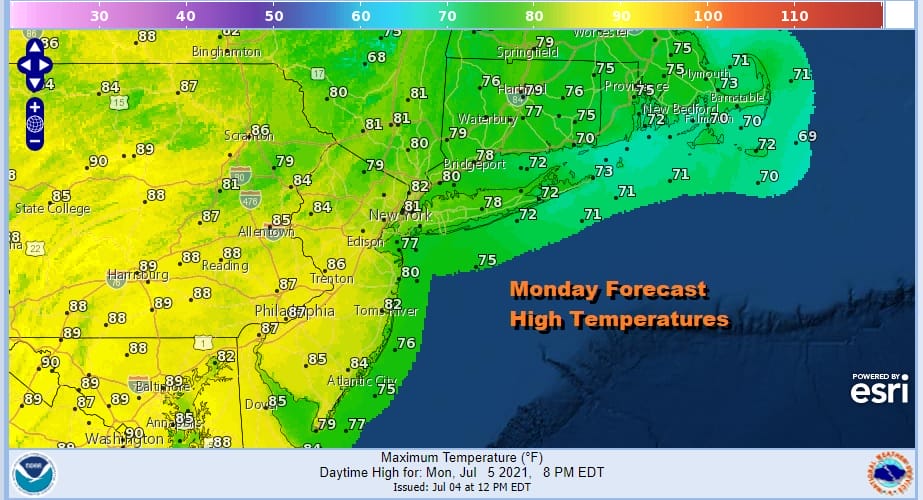
Monday starts the trend to warmer and more humid conditions though the humidity will still be on the moderate side. We should have partly to mostly sunny skies Monday with highs reaching upper 80s to near 90 across Southern Pennsylvania and Southern New Jersey southward while temperatures will be in the 70s across Southern New England and Long Island. 80s are likely in between.
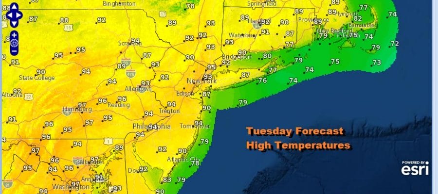
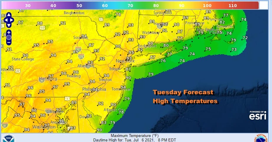
Tuesday starts the trip to heat and humidity with sunshine taking highs to the low and middle 90s away from coastal areas where the sea breeze will knock the temps down by about 10 degrees or so. We will throw in the chance for a pop up isolated shower or thunderstorm dew to the dew points approaching 70 but they should be minimal.
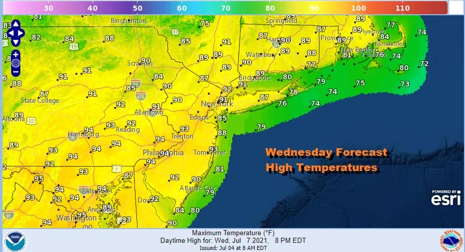
Wednesday will be a repeat performance of Tuesday with heat and humidity. Highs again will be in the low to mid 90s away from the ocean. There is a higher chance for thunderstorms developing late Wednesday afternoon and evening as the next upper trough and cold front begin their approach from the west.
Thursday offers the highest chance for showers and thunderstorms. The day will be very warm and humid with highs reaching the 80s to around 90 degrees. Dew points will be reaching into the 70s and the cold front should set off more numerous thunderstorms in an unstable atmosphere.
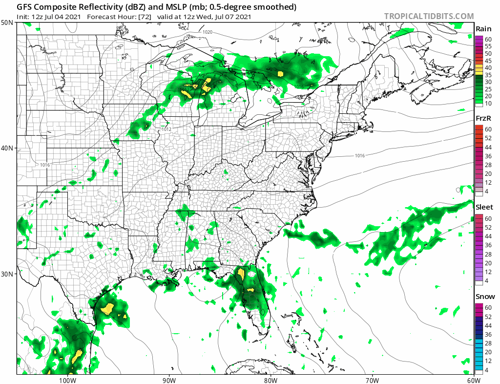
The one question that hangs for Thursday is whether the remnants of Elsa somehow get involved and enhance the rain a bit as the front moves through. The GFS model shows the moisture being absorbed by the cold front with a weak remnant low. This doesn’t appear to be something that could cause big issues as far as rainfall is concerned here though we will keep an eye on it. Otherwise the front should pass and weather conditions should improve nicely on Friday.
BE SURE TO DOWNLOAD THE FREE METEOROLOGIST JOE CIOFFI WEATHER APP &
ANGRY BEN’S FREE WEATHER APP “THE ANGRY WEATHERMAN!

MANY THANKS TO TROPICAL TIDBITS & F5 WEATHER FOR THE USE OF MAPS
Please note that with regards to any severe weather, tropical storms, or hurricanes, should a storm be threatening, please consult your local National Weather Service office or your local government officials about what action you should be taking to protect life and property.


