SHOWERS MOVE THROUGH TO THE EAST,WEATHER CONDITIONS IMPROVE
SUNSHINE TUESDAY, HALLOWEEN LOOKING NICE & WARM
We are seeing a weather system move through this morning and it has already produced a few showers and even some rumbles of thunder this morning. This is a weak weather system and cold front moving through We will see everything pull away to the northeast this morning and leftover clouds will give way to some breaks of sunshine. Temperatures will be in the 50s to near 60 this afternoon. We can see the rotation clearly on the satellite loop this morning as the upper air system moves on through.
EASTERN SATELLITE

REGIONAL RADAR

Regional and local radars are showing bands of showers and even a few thunderstorms now to the east in the coastal waters. All of this translates to the east today and showers should diminish in coverage and intensity.
LOCAL RADAR NEW YORK CITY

LOCAL RADAR PHILADELPHIA


We have a chilly night ahead but nothing overly cold with lows in the mid 30s to lower 40s. Tuesday should be nice and sunny with just a few passing clouds with highs in the 50s to near 60.
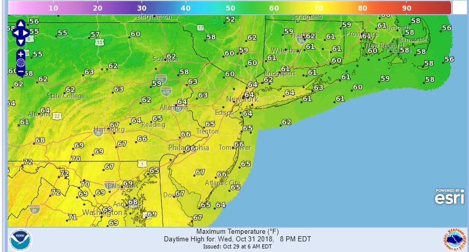
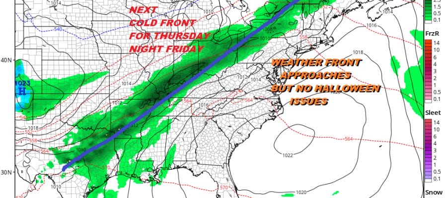
Wednesday is Halloween and it is looking like a nice day with very little in the way of complications with sunshine and a southwest wind. Temperatures will reach the middle and possibly even the upper 60s . We are going to be sitting a head of a cold front that will be producing some showers to the west but that front is forecast to weaken as it moves eastward at least initially so we don’t expect any issue fromt it at least on Wednesday.
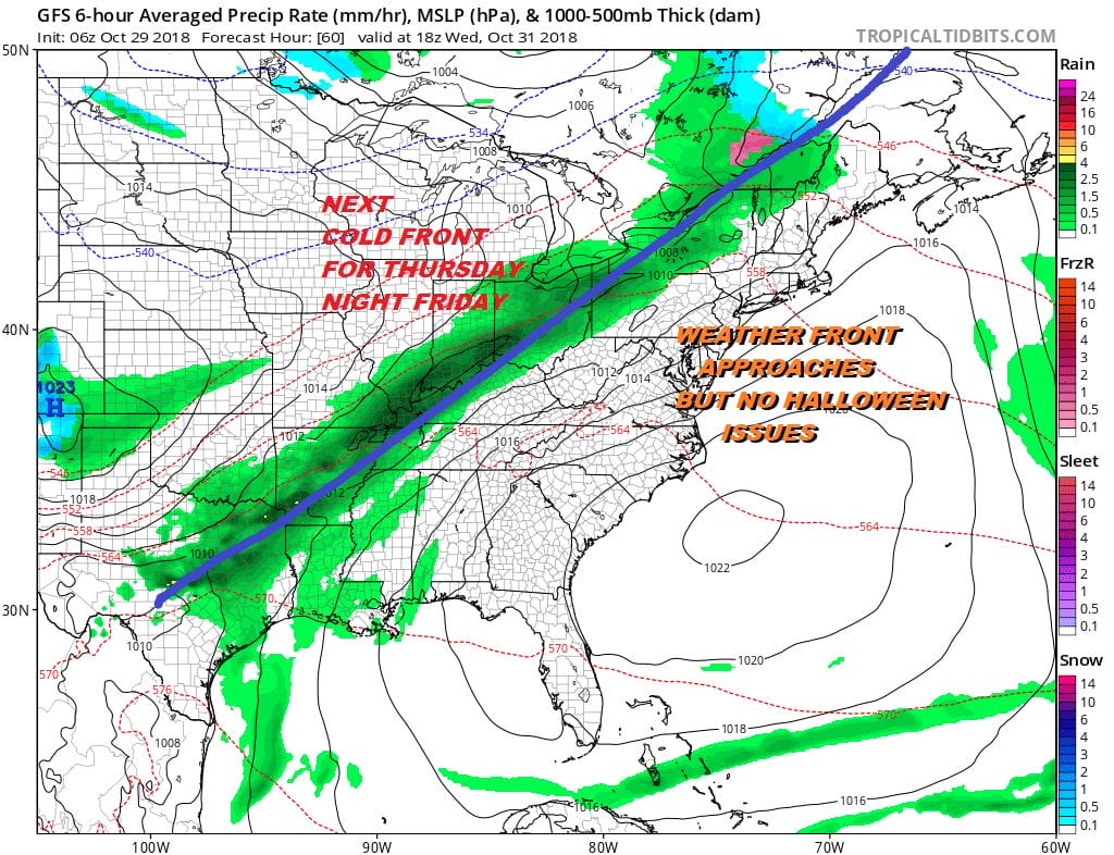
That next cold front will make its final approach here Thursday night and Friday. Showers will likely develop later on Thursday and last into early Friday morning with highs in the 60s. The question is whether that front stalls out or not and whether we see another wave or two develop on the front to impact the weekend.
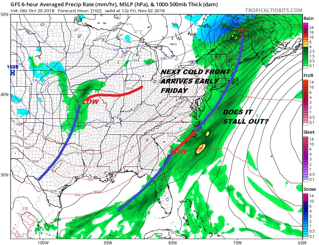
Right now it seems that everything should move along to allow for some improvement though the next wave forecast off the South Carolina coast will likely make it a close call. The European model has a different view of this as it never gets the first front through here and has that wave off the South Carolina coast much further to the west making for a rather showery Friday with slow improvement for the weekend. The Europeans performance with the noreaster this weekend was better than the GFS and it seems to be having a bit of a hot hand so we will lean to a more wetter solution for the end of the week with the European’s idea the more likely outcome.
SUBSCRIBE TO PATREON FOR A WEATHER EXPERIENCE FREE OF ADS, EXCLUSIVE VIDEOS FOR MEMBERS ONLY AND MUCH MORE…STARTS AT $2 A MONTH..MESSAGE ME AT ANY TIME

MANY THANKS TO TROPICAL TIDBITS FOR THE USE OF MAPS
Please note that with regards to any tropical storms or hurricanes, should a storm be threatening, please consult your local National Weather Service office or your local government officials about what action you should be taking to protect life and property.
LATEST JOESTRADAMUS ON THE LONG RANGE

