Gloom & Doom Three Storm Systems Over the Next 7 Days
4 Inches or More of Rain Forecast

Gloom & Doom Three Storm Systems Over the Next 7 Days
4 Inches or More of Rain Forecast
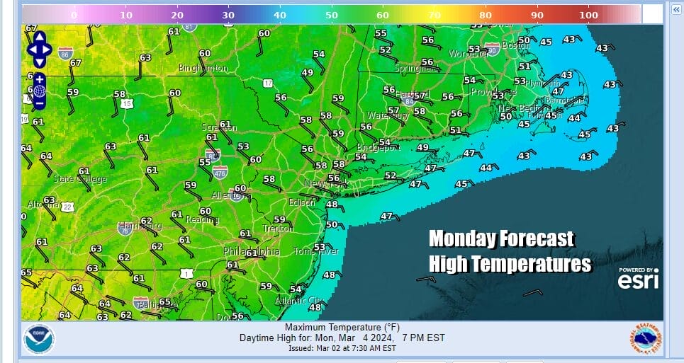
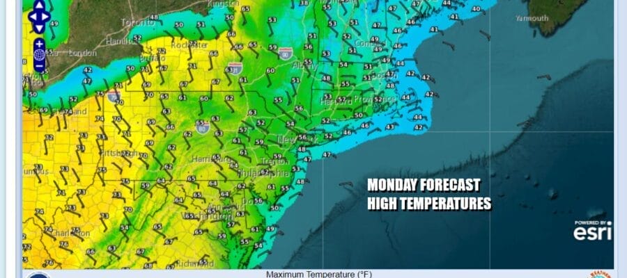
After a beautiful of record breaking highs, today, Monday, will be a bit different thanks to a developing onshore flow that brings cooler ocean air inland. Also we are seeing the atmosphere bring primed ahead of a developing low off the North Carolina coast. This is not going to be a strengthening system and yet when we look at this on satellite loops and radar loops, we are noting an expanding area of bright wide clouds and an increasing but concentrated area of rain off the North Carolina coast. This system will organize today but ahead of it we will see any morning low clouds burn away, only to eventually give way to clouds coming up from the south late this afternoon and evening. There will be a wide range in temperatures today from the 40s along the immediate coast to lower 60s well inland and south as the map above shows.
SATELLITE WITH LIGHTNING STRIKES

WEATHER RADAR

This clearly will not be a good weather week overall with three storm systems in play. The first one to the south will creep up the coast tonight spreading rain northward but it is confined inside a tight little ball of rain. Some heavier rain is possible but this system being small will play through rather quickly. By Tuesday afternoon rain will be ending from southwest to northeast as this low straddles the coast before moving away.

No sooner than the first low moves out we have a second and stronger system that will have more moisture that will cover more of widespread area of geography in the Northeast. Cloudy skies Tuesday night into Wednesday morning will give way to developing rain Wednesday afternoon and lasting into at least part of Thursday. Some of the rain will be heavy especially during Wednesday night. We are looking for rather raw conditions developing starting Tuesday and lasting into Thursday with most temperatures hovering in a range of upper 40s to middle 50s. A third system will approach with more rain later Friday and lasting through much of Saturday.
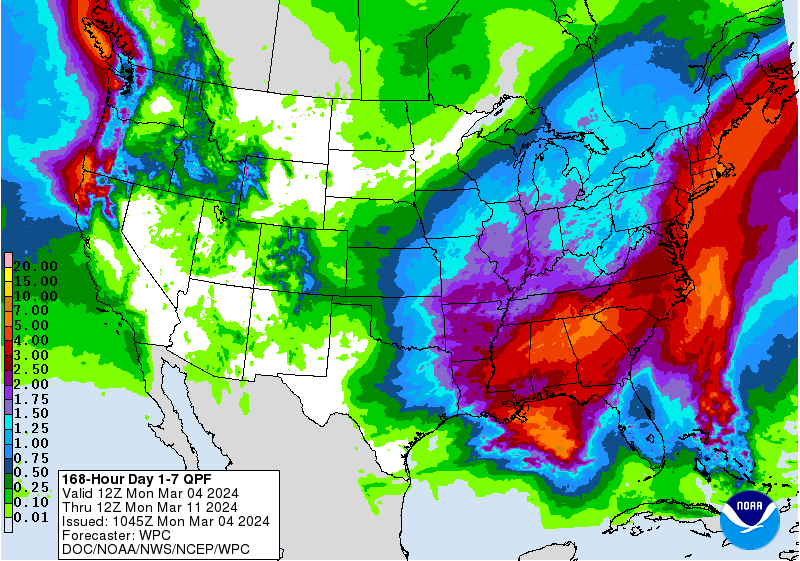
When this weekend is all said and done and the third and final storm system departs, we will be looking at the possibility of 4 inches or more of rain from Southeastern New England southward to the Delmarva peninsula. Given that lately we have been seeing systems outperforming model guidance it would not surprise us to see some areas finishing with well above the 4 to 5 inch range shown by the Weather Prediction center forecast. This is no doubt a gloom and doom week so take advantage of dry times whenever they show up.
BE SURE TO DOWNLOAD THE FREE METEOROLOGIST JOE CIOFFI WEATHER APP &
ANGRY BEN’S FREE WEATHER APP “THE ANGRY WEATHERMAN!
MANY THANKS TO TROPICAL TIDBITS FOR THE USE OF MAPS
Please note that with regards to any severe weather, tropical storms, or hurricanes, should a storm be threatening, please consult your local National Weather Service office or your local government officials about what action you should be taking to protect life and property.
(Amazon is an affilate of Meteorologist Joe Cioffi & earns commissions on sales.)


