Flood Watches & Severe Weather Risk Late Tuesday into Wednesday Morning Debby Rains Late Week

Flood Watches & Severe Weather Risk Late Tuesday into Wednesday Morning Debby Rains Late Week
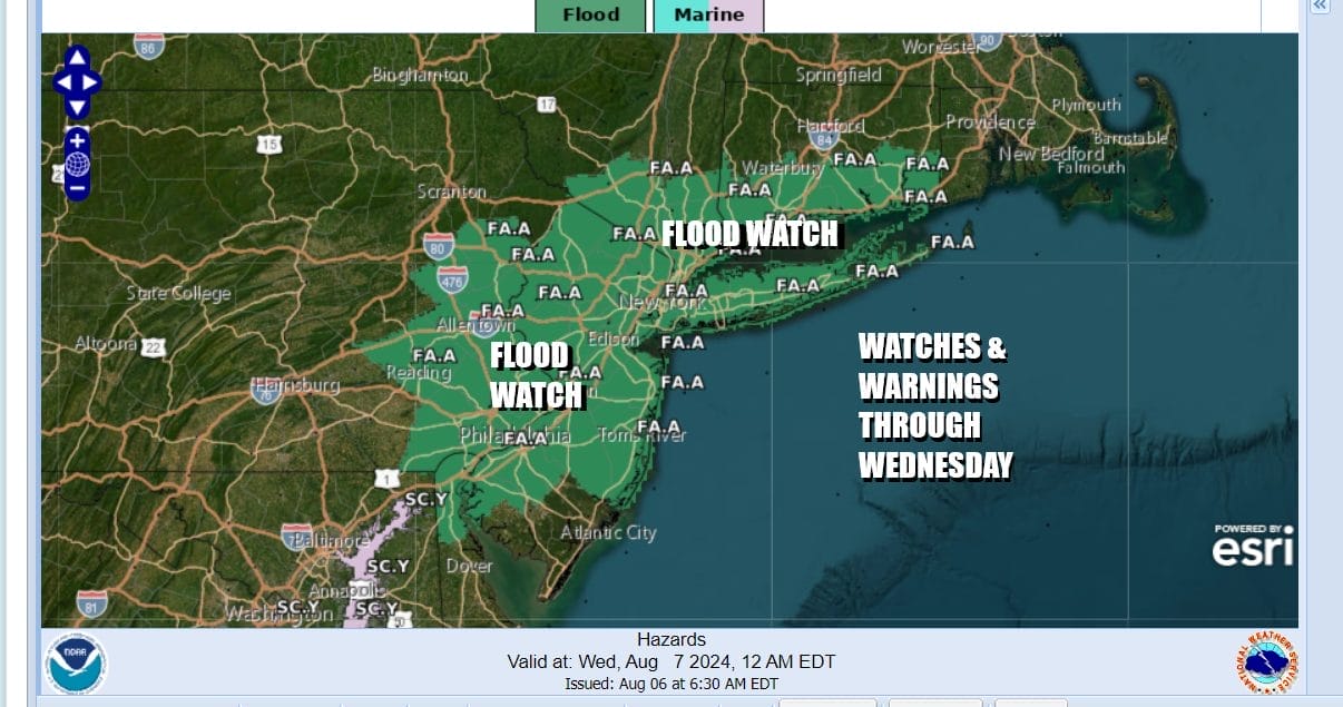
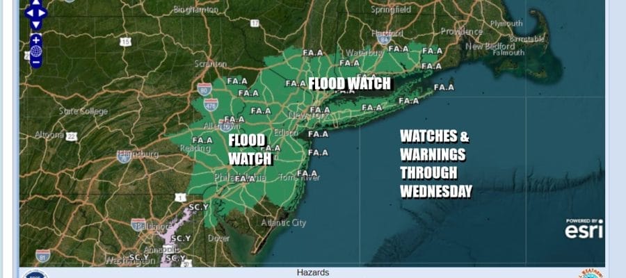
Two separate upper air patterns are at work long the East Coast. We have the westerly flow across the Great Lakes moving upper troughs and weather fronts from west to east. The latest in the series arrives late today as a front presses southeastward from the northwest. This leaves us at risk for thunderstorms with the potential for heavy rain and flash flooding. Flood watches are posted for much of Eastern Pennsylvania to Southern New England.

Along with the flash flooding risk we have severe weather risk as well. The Storm Prediction Center has expanded the slight risk zone from Ohio to New Jersey with marginal risk for isolated severe thunderstorms across Northern Pennsylvania to the Hudson Valley, Western Connecticut and Long Island to the east and Delaware, Maryland, and Northern Virginia to the south.
SATELLITE WITH LIGHTNING STRIKES

WEATHER RADAR

We will see showers and thunderstorms develop later today across Upstate NY and Pennsylvania and gradually those storms will shift east and southward late today and continue tonight into Wednesday. There will be sunshine giving way to arriving clouds so the increasing cloud cover today will help to keep temperatures in the lower 80s north of NYC and mid to upper 80s to the south.

Showers and thunderstorms will continue overnight into Wednesday morning before the front pushes to the south but it will remain close by. Wednesday will be a cloudy day with showery rains and some thunder for at least the first part of the day and perhaps tapering off a bit from north to south late Wednesday into Wednesday night. Temperatures Wednesday will not get out of the 70s.

Rainfall amounts of up to 2 to 2.5 inches of rain are possible but as always when dealing with situations in the summertime that include thunderstorms, some areas could see double those amounts if a stronger thunderstorm sits over any particular area for a period of time. This rainfall is not related to the rainfall from Tropical Storm Debbie which continues to bring historic and potentially catastrophic rainfall in the Southeastern US.
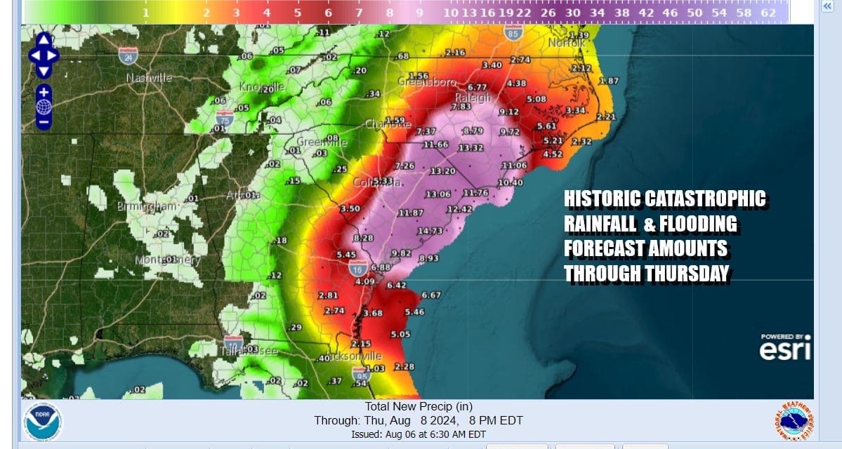
Tropical Storm Debby rainfall forecast amounts are for an additional 10 to 15 inches of rain on top of rain that has fallen yesterday and overnight. Southeast Georgia across to the southern half of South Carolina and into southern and central parts of North Carolina are the areas that are hardest hit by Debby. The tropical storm emerges into the Southwest Atlantic today and could strengthen again before making another landfall in South Carolina. Charleston eastward to Myrtle Beach seems to be the most likely area for a second landfall.

After the second landfall which happens Thursday morning, Debby will move inland and head north and eventually northeastward spreading heavy rain up the coast through the Mid Atlantic states and into the Northeast. Timing is a little hazy but it would seem that areas across the Mid Atlantic will see heavy rain developing Thursday night into Friday and then areas further north will see rain develop later Friday and lasting into the first part of Saturday. Rainfall amounts will depend on the track of the low. Global model tracks are inland which would mean that the heaviest rain of several inches (or possibly more) will fall west and northwest of the storm track. Hurricane tracking models show a track further east and closer to the coast. We will need to work this part of the forecast out over the next 2 days We will see some heavy rain from Debbie. The good news is that once Debby moves away it will pull down a nice dry air mass into the Eastern US for the rest of the weekend and into early next week. If you have been waiting for a long stretch of low humidity, you may get your wish after the storm departs.
BE SURE TO DOWNLOAD THE FREE METEOROLOGIST JOE CIOFFI WEATHER APP &
ANGRY BEN’S FREE WEATHER APP “THE ANGRY WEATHERMAN!
MANY THANKS TO TROPICAL TIDBITS FOR THE USE OF MAPS
Please note that with regards to any severe weather, tropical storms, or hurricanes, should a storm be threatening, please consult your local National Weather Service office or your local government officials about what action you should be taking to protect life and property.
(Amazon is an affilate of Meteorologist Joe Cioffi & earns commissions on sales.)


