Flood Watches, High Wind Warnings, Winter Storm Warnings & Advisories Major Storm & Cold Front

Flood Watches, High Wind Warnings, Winter Storm Warnings & Advisories Major Storm & Cold Front
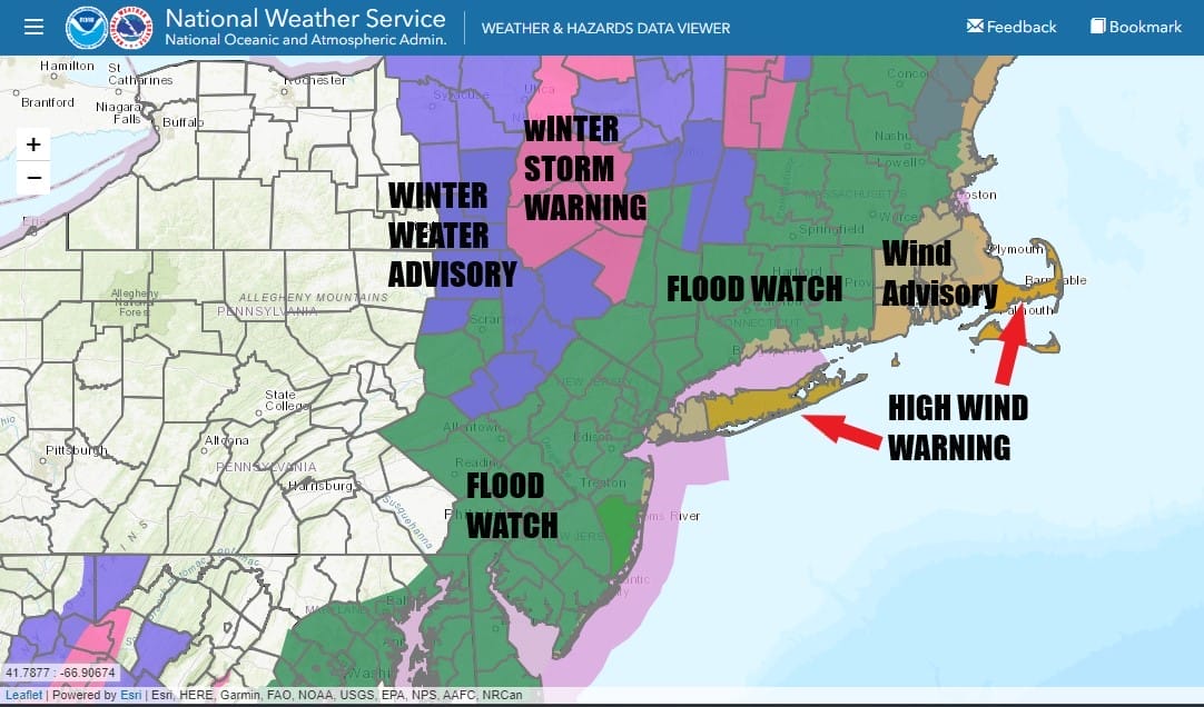
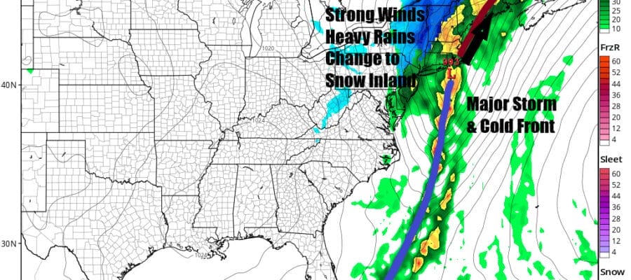
We have much going on today in the Northeast and Mid Atlantic states so it really depends on where you are located in terms of impact. Flood watches cover the largest amount of geography with watches extended from Northeast Virginia all the way into New England. High wind warnings are up for Central and Eastern Long Island as well as Southeastern New England with wind advisories up for much of coastal Southern and Southeastern New England.
SATELLITE WITH LIGHTNING STRIKES

WEATHER RADAR

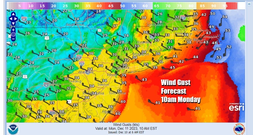
Weather conditions will deteriorate today as rain and even some thunderstorms advance eastward ad overspread the area from west to east this afternoon. Temperatures will be into the 60s in many locations until the cold front passes. Southerly winds will increase along the coast and you can expect gusts of 50 mph possible in areas where we have high wind warnings. Below is a snapshot of wind gusts forecast for 7pm Sunday.

Next is the rain which will be heavy at times especially this evening and overnight. Rainfall amounts will be substantial. Most areas will see 2 to 3 inches of rain in this short period of time which will probably cause some localized flooding. Some areas in Southern New England could see 3 inches or more and I would not rule that out for anyone in Eastern Pennsylvania to Southern New England especially if a thunderstorm or two were to get involved.

The next issue is a change to snow inland. The way this is setting up i think accumulating snows will generally be elevation driven with higher amounts the higher up you go. This certainly favors the Poconos to the Catskills which is where we have Winter Weather Advisories up. Winter Storm Warnings are up for areas in the Catskills as you move away from the NY/NJ/PA border.
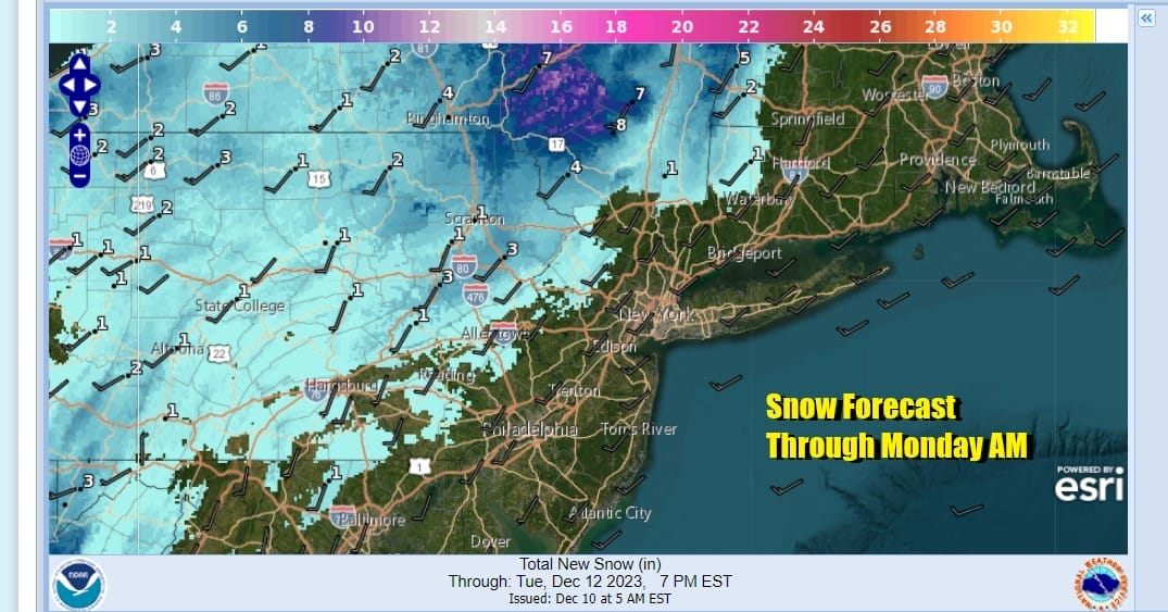
Areas from South Central Pennsylvania to Northwest New Jersey and the Hudson Valley near and just north of Route 84 will be the southern edge of any accumulating snow. Highest amounts will be further north in Upstate NY and then east into Northern New England. Many areas closer to the coast might see a change to sleet and snow before ending but I don’t think accumulation is an issue in these areas.

The loop of the HRRR starts from 1pm Sunday until 1pm Monday so you can see the progression of the cold front and the developing low that forms tonight and heads to near Eastern Long Island Monday morning. As far as winds are concerned, the first part of the wind issue will be at the coast and not so much inland. However winds will become more of an issue during Monday inland as well as the coast as the low strengthens and the northwest wind picks up everywhere. Gusts will be in the 30 to 40 mph range.
Temperatures Monday will fall into the 30s as weather conditions improve as the day wears on other than the gusty winds. Leftover clouds and developing sunshine will take over during Monday afternoon. Then skies will clear out. Much of the week ahead looks to be on the calm side with temperatures one or two degrees either side of average for this time of year and no weather drama through at least next Saturday.
BE SURE TO DOWNLOAD THE FREE METEOROLOGIST JOE CIOFFI WEATHER APP &
ANGRY BEN’S FREE WEATHER APP “THE ANGRY WEATHERMAN!
MANY THANKS TO TROPICAL TIDBITS FOR THE USE OF MAPS
Please note that with regards to any severe weather, tropical storms, or hurricanes, should a storm be threatening, please consult your local National Weather Service office or your local government officials about what action you should be taking to protect life and property.
(Amazon is an affilate of Meteorologist Joe Cioffi & earns commissions on sales.)


