Flood Watch New Jersey Eastern Pennsylvania Route 78 South
Flood Watch New Jersey Eastern Pennsylvania Route 78 South

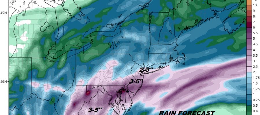
We have seen a good amount of rain in some areas in the last number of days and the ground from Northern New Jersey (Route 78 South) across the same area in Pennsylvania is fairly saturated. Add another several inches of rain or more and you have a flood watch up for this area through Saturday. We continue to watch a front buckle back and forth north and south and this is going to continue into Saturday. The NAM model along with others are very bullish with rain amounts.
EASTERN SATELLITE

REGIONAL RADAR

The regional radar is loaded to the south with patches of heavy rain and thunderstorms. Some rain will come in overnight into midday Thursday before the front pushes south again. This should allow some temporarry drying from north to south Thursday afternoon but how far south the rain shield gets is a question. Areas from NYC north and northwest are likely to see some brightening of skies Thursday afternoon or even some sun with highs reaching into the 70s. Areas in South Jersey, Southeastern Pennsylvania will likely fight clouds all day and more rain will develop overnight into Friday.
LOCAL RADAR NEW YORK CITY

LOCAL RADAR PHILADELPHIA


That rain on Friday will slowly push northward as the front comes back north again. Heavy rain is likely later Friday across the watch area and then spread northward Friday night into Saturday into the Hudson Valley & Southern New England. Saturday looks wet at least at the start but we could catch a break in the action Saturday night into Sunday as the front moves north again. Then it comes back the other way later Sunday with the chance for showers and thunderstorms.
JOE & JOE WEATHER SHOW
 GET JOE A CIGAR IF YOU LIKE

FiOS1 News Weather Forecast For Long Island
FiOS1 News Weather Forecast For New Jersey
FiOS1 News Weather Forecast For Hudson Valley


