Flood Watch Coastal Flooding Issues Weekend Forecast
Flood Watch Coastal Flooding Issues Weekend Forecast
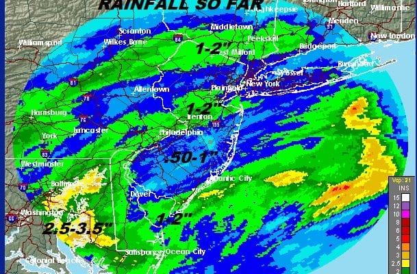
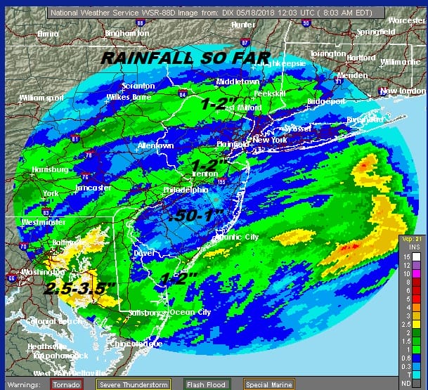
So far the rainfall amounts have been anywhere from a 1/2 inch to 2 inches since Wednesday across the area but note the uneven distribution of the rain. The heaviest of the rain has been in Southeastern Pennsylvania Southward and also in a band from Northeast Pennsylvania, across the Hudson Valley and extending into Connecticut.
We are still in the land of doom and gloom with the satellite showing us in a ton of clouds. A gusty onshore flow has developed and that has created a coastal flooding issue at high tide for Western Long Island Sound, the counties in New Jersey surrounding NY Harbor and the New Jersey shore with minor coastal flooding expected. Then there is the rain issue and flood watches continue from New Jersey & Eastern Pennsylvania south of Route 78.
EASTERN SATELLITE

Rain is on the radar to the south in the Southern half of New Jersey this morning and we see heavy rain in Delaware & parts of Maryland. For now the northward progress of the rain will be limited due to high pressure to the north but eventually tonight the high will break down enough to allow that rain to the south to begin moving northward. Temperatures today will be mainly in the upper 50s and lower 60s at best.
REGIONAL RADAR

LOCAL RADAR NEW YORK CITY

LOCAL RADAR PHILADELPHIA


Overnight into Saturday the rain moves northward and plays through. Another 1/2 inch to an inch of rain is forecast for most areas with higher amounts in areas where the flood watch continues. The rain will start to end from south to north during the day Saturday or at least taper off to showers during the afternoon and evening.
SUNDAY FORECAST HIGH TEMPERATURES
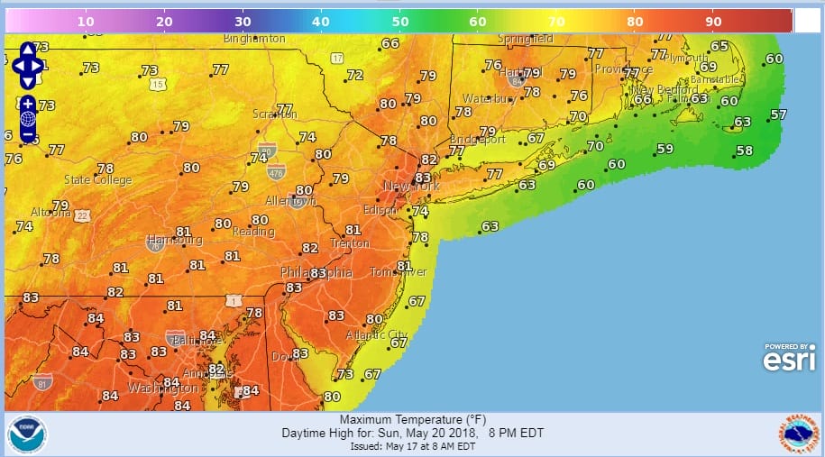
Sunday sees some improvement with clouds and sunshine warm and rather humid conditions at least for awhile with temperatures reaching into the 80s. There is the chance for a passing shower or thunderstorm but most of the area will be rain free. Next week we will be seeing a battle between the northern jet stream in Canada that could at least dry things out a bit around here verses the tropical flow from the Caribbean to the Northeast and whether that connection breaks down. Right now Monday looks dry for the most part with at least some sunshine before weather fronts and the chance for showers comes back into the forecast later Tuesday and beyond.
JOESTRADAMUS HAS HIS LATEST LOOK AT THE TROPICS AND THE LONG RANGE
 GET JOE A CIGAR IF YOU LIKE

FiOS1 News Weather Forecast For Long Island
FiOS1 News Weather Forecast For New Jersey
FiOS1 News Weather Forecast For Hudson Valley
NATIONAL WEATHER SERVICE SNOW FORECASTS
LATEST JOESTRADAMUS ON THE LONG RANGE


