Flash Flood Watch Severe Weather Threat Monday
Flash Flood Watch Severe Weather Threat Monday
The Flash Flood Watch for Monday afternoon and Monday night has now been extended to cover all of New Jersey except the coastal coutnies and the extreme northwest part of the state, New York City & Nassau County are now included in the Flash Flood Watch as well as all of Connecticut, the Hudson Valley & a small portion of Eastern & Southeaster Pennsylvania.
There are no weather issues for tonight other than some patchy fog, It will be warm and humid with most lows in the mid 60s to lower 70s. The first part of Monday should be dry. The cold front to the west is evident on the satellite and radar loops this evening as thunderstorms are developing across Western Pennsylvania and Western NY but these will die off before reaching here.
SATELLITE LOOP

REGIONAL RADAR

LOCAL RADAR NEW YORK CITY

LOCAL RADAR PHILADELPHIA


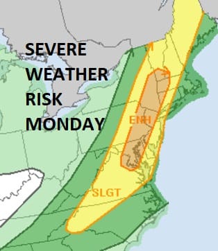
The main thunderstorm threat will evolve later Monday afternoon across Eastern Pennsylvania and Northwestern New Jersey and the Catskills and then spread east across New Jersey, New York City, Long Island, Connecticut & the Hudson Valley Monday evening. Ths Storm Prediction Center still has the entire area from Virginia to Maine in a slight risk for severe thunderstorms with an area of enhanced risk from Washington to New York City.

Weather models this afternoon are pretty much in agreement with the idea of a squall line developing Monday evening Strong wind gusts of 60 mph or more and heavy rain will occur in some areas. I would not be surprised to see some sort of severe weather watches go up for Monday evening for a large part of our area.
LANDSCAPE COMPANIES FOR YOUR NEEDS
LONG ISLAND ROCKLAND COUNTY Connecticut

![]()

ROCKLAND COUNTY TRI STATE SNOW REMOVAL JOHNSTOWN PA


FiOS1 News Weather Forecast For Long Island
FiOS1 News Weather Forecast For New Jersey
FiOS1 News Weather Forecast For Hudson Valley
NATIONAL WEATHER SERVICE SNOW FORECASTS
LATEST JOESTRADAMUS ON THE LONG RANGE
Weather App

Don’t be without Meteorologist Joe Cioffi’s weather app. It is really a meteorologist app because you get my forecasts and my analysis and not some automated computer generated forecast based on the GFS model. This is why your app forecast changes every 6 hours. It is model driven with no human input at all. It gives you an icon, a temperature and no insight whatsoever.
It is a complete weather app to suit your forecast needs. All the weather information you need is right on your phone. Android or I-phone, use it to keep track of all the latest weather information and forecasts. This weather app is also free of advertising so you don’t have to worry about security issues with your device. An accurate forecast and no worries that your device is being compromised.
Use it in conjunction with my website and my facebook and twitter and you have complete weather coverage of all the latest weather and the long range outlook. The website has been redone and upgraded. Its easy to use and everything is archived so you can see how well Joe does or doesn’t do when it comes to forecasts and outlooks.
Just click on the google play button or the apple store button on the sidebar for my app which is on My Weather Concierge. Download the app for free. Subscribe to my forecasts on an ad free environment for just 99 cents a month.
Get my forecasts in the palm of your hand for less than the cost of a cup of Joe!


