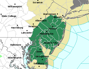
FLASH FLOOD WATCH NEW JERSEY
[brid video=”56254″ player=”6390″ title=”wednesday”]
FLASH FLOOD WATCH NEW JERSEY
The National Weather Service has posted FLASH FLOOD WATCH for New Jersey along and south of Route 78 beginning Thursday evening and continuing until Friday evening.
Right now and into Thursday evening there are no weather issues. Thursday will be the last day of 90 degree temperatures as the heatwave continues to wind down. Thursday night we will start to see rain move in from the west as low pressure moves out of the Ohio Valley and heads for the New Jersey coast.The satellite loop shows the disturbance in the western Great Lakes and tropical moisture beginning to build across the Ohio and Tennessee Valleys.
FLASH FLOOD WATCH NEW JERSEY SATELLITE & RADAR LOOPS


Weather models late this afternoon are beginning to line up better with the GFS model coming into better alignment with the more bullish NAM models. The question is where does the radar set up with the heavy rain. This is the kind of setup where somebody could get slammed pretty hard with 3 inch plus rainfalls.
FLASH FLOOD WATCH NEW JERSEY LATEST MODEL FORECASTS
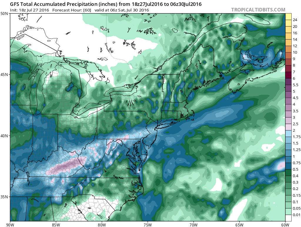

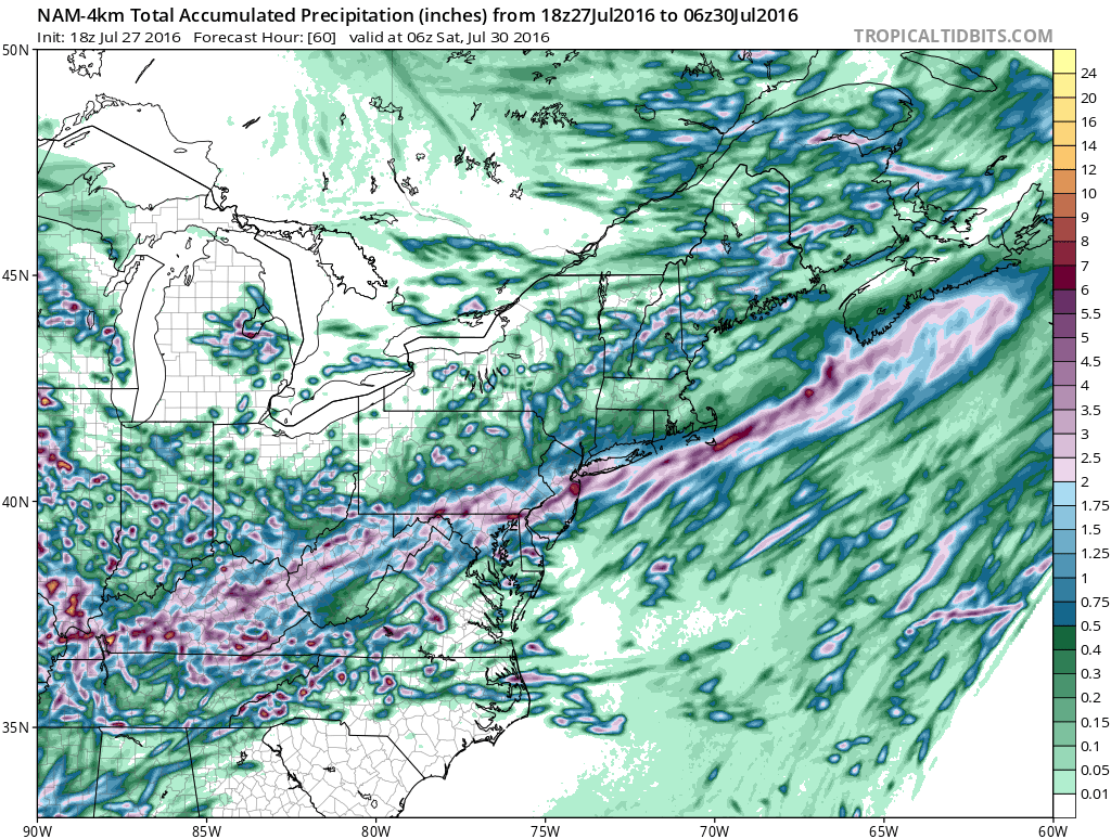
One of the NAM models lines up with the European weather model which wants to show the band of heaviest rains of 1 to 3 inches across Northern New Jersey and into the Hudson Valley while the others are further south. The very tight gridded NAM 4KM model which usually works well with thunderstorms goes nuts with rainfall amounts of 4 to 5 inches in some places that were placed under the Flash Flood Watch. The outcome that is most beneficial is the track of the rainfall to the north. Northern New Jersey and the Hudson Valley are suffering under drought conditions. We will of course reevaluate the situation overnight and on Thursday. Again no rain is forecast until Thursday night when the low moves toward the coast.
FiOS1 News Weather Forecast For Long Island
FiOS1 News Weather Forecast For New Jersey
FiOS1 News Weather Forecast For Hudson Valley
NATIONAL WEATHER SERVICE SNOW FORECASTS
LATEST JOESTRADAMUS ON THE LONG RANGE
Weather App

Don’t be without Meteorologist Joe Cioffi’s weather app. It is really a meteorologist app because you get my forecasts and my analysis and not some automated computer generated forecast based on the GFS model. This is why your app forecast changes every 6 hours. It is model driven with no human input at all. It gives you an icon, a temperature and no insight whatsoever.
It is a complete weather app to suit your forecast needs. All the weather information you need is right on your phone. Android or I-phone, use it to keep track of all the latest weather information and forecasts. This weather app is also free of advertising so you don’t have to worry about security issues with your device. An accurate forecast and no worries that your device is being compromised.
Use it in conjunction with my website and my facebook and twitter and you have complete weather coverage of all the latest weather and the long range outlook. The website has been redone and upgraded. Its easy to use and everything is archived so you can see how well Joe does or doesn’t do when it comes to forecasts and outlooks.
Just click on the google play button or the apple store button on the sidebar for my app which is on My Weather Concierge. Download the app for free. Subscribe to my forecasts on an ad free environment for just 99 cents a month.
Get my forecasts in the palm of your hand for less than the cost of a cup of Joe!

MENTION JOE CIOFFI AND GET A 5% DISCOUNT


