Dry Weather Continues Into Friday Hot Finish to the Week
Showers Thunderstorms Saturday

Dry Weather Continues Into Friday Hot Finish to the Week
Showers Thunderstorms Saturday

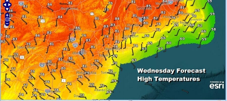
We are still under the influence of an onshore flow but that is in the process of slowly relaxing. Other than an arc of coastal clouds that developed overnight overall today it should be a partly to mostly sunny day. The relaxing onshore flow will mean for slightly higher temperatures this afternoon inland. Highs will reach the mid to upper 70s in most places. The exception of course will be the immediate coast, east and south facing shorelines and the like where temperatures will probably top out in the 60s. Such has been the case the last few days but the ocean wind flow will continue to lessen in the coming days.
SATELLITE

WEATHER RADAR

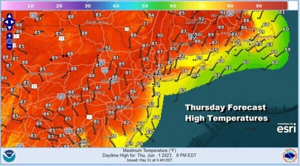
Most lows tonight will be in the mid 50s inland and lower 60s coast and warmer urban locations under clear skies for the most part. Thursday we will see the winds go more south and southwest and with sunshine that should take inland temperatures to the low and middle 80s just above every where with 70s along the immediate coast and south and east facing shorelines.
A cold front will be dropping southward from Eastern Canada and into New England. This front and high pressure that will be to our south sets up more of a northwest wind away from the ocean. That wind direction is the catalyst for hot temperatures and Friday we will see temperatures reach into the 90s. Dew points will behave and remain in the 50s which means that the humidity won’t be a real issue for most except for the ultra sensitive.
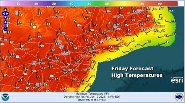
For now I am going to leave the chance for a pop up shower or thunderstorm out of the forecast Friday. Instead we will focus on Saturday for the likelihood of showers and thunderstorms. Cold fronts that back down from New England usually come through dry but this one is a bit different because it does come with am upper air shortwave. The front is also pushing south into an air mass of rising dew points.

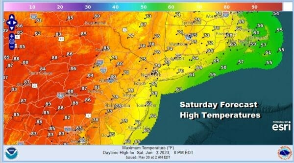
This front will likely produce some showers and thunderstorms Saturday as it passes through. It will also mean for cooler temperatures between cloud cover and the showers. Highs Saturday will be in the upper 70s to lower 80s as winds go around from the southwest to the northeast when the front passes. I think there is the risk there could be a stronger thunderstorm or two in the mix.
Im not exactly sure what to do about Sunday at this stage as models diverge. Some take the front south into Virginia with cool high pressure building in while some have the next high wedging into New England with ans onshore flow and lingering showers Saturday night into Sunday.

Either way we will wind up with an ocean wind and this will mean that temperatures will be in the cooler 70s with 60s along the shore. My original idea was the Sunday would be the better of the two weekend days but this seems to be a bit less likely if we see the front stall to the south and low pressure offshore bringing rain back in westward. We will attempt to bring some clarity to this later today.
BE SURE TO DOWNLOAD THE FREE METEOROLOGIST JOE CIOFFI WEATHER APP &
ANGRY BEN’S FREE WEATHER APP “THE ANGRY WEATHERMAN!
MANY THANKS TO TROPICAL TIDBITS FOR THE USE OF MAPS
Please note that with regards to any severe weather, tropical storms, or hurricanes, should a storm be threatening, please consult your local National Weather Service office or your local government officials about what action you should be taking to protect life and property.
(Amazon is an affilate of Meteorologist Joe Cioffi & earns commissions on sales.)


