
Downtrend in Temperatures But Still Warm
Sunday Cold Front Brings Showers & Sharply Colder Air
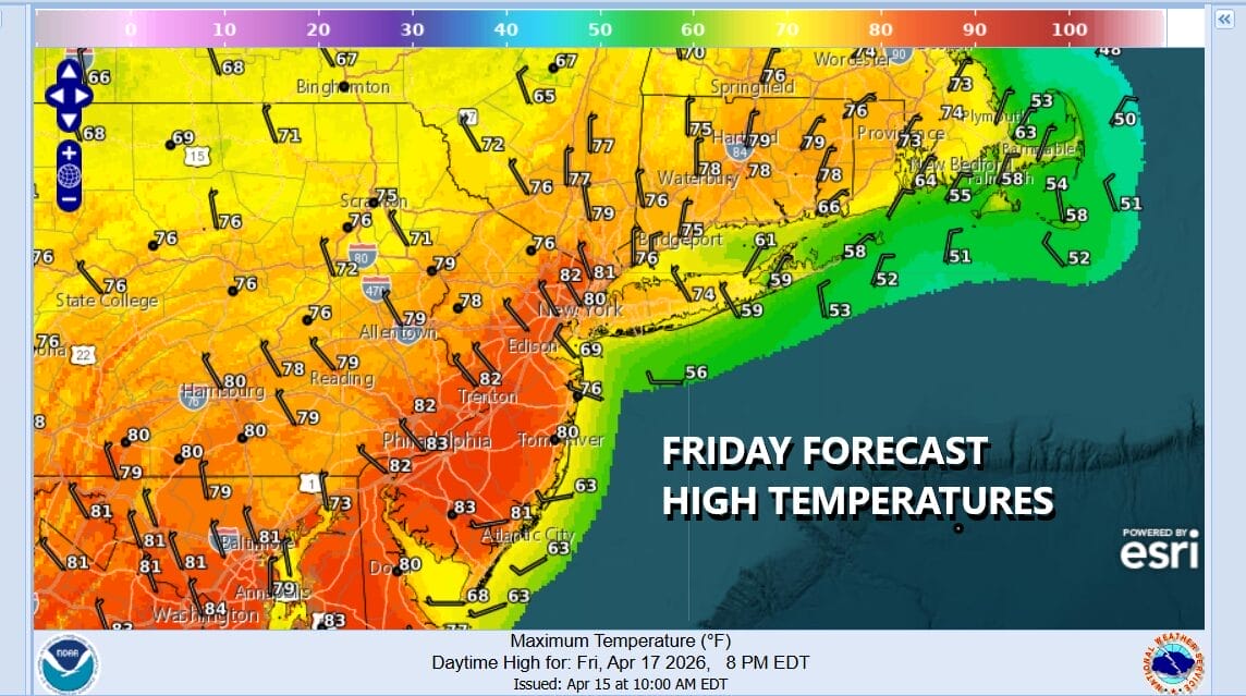
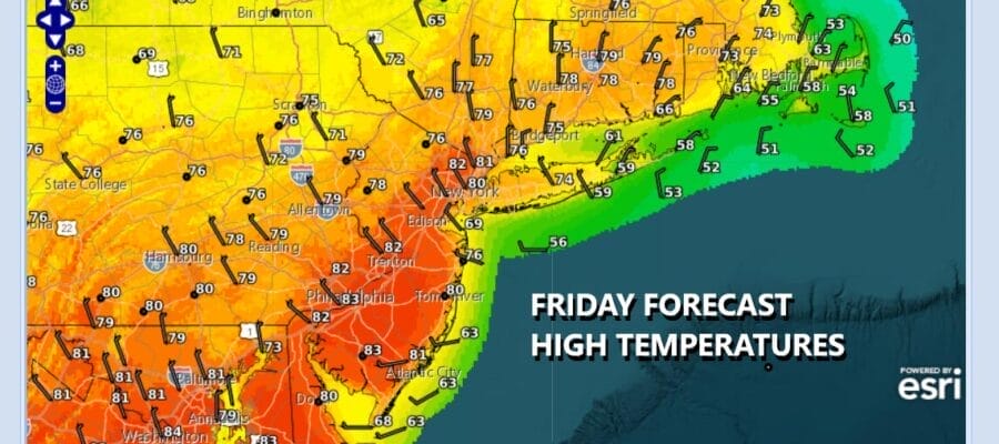
An upper trough brought a few showers through overnight and these showers have now moved to the east. We are going to see clouds give way to some sunshine however the trough itself has yet to pass offshore so we need to include the risk there could be some scattered showers or an isolated thunderstorm later today. There should be enough sun and enough dry time to take temperatures up into the lower 80s inland with 70s along the coast. The peak temperatures of the last several days are now passed and we will see temperatures trending lower over the next 2 days and sharply lower beginning late Sunday and through the first couple of days of next week.
SATELLITE WITH LIGHTNING STRIKES

WEATHER RADAR

Expect some clouds around tonight with most Saturday morning lows in the 50s. Saturday dayside will be dry but the wind will be from off the ocean and this is going to keep temperatures lower. There will be a wide range of high temperatures ranging from the 50s along the immediate coast, rising into the 70s inland. Western New Jersey into Pennsylvania will see highs in the upper 70s and lower 80s.

Skies will be mostly sunny Saturday but clouds will be rolling in Saturday night ahead of of sharp cold front that will pass Sunday morning. We will see a few showers from the front but rain amounts will be generally a quarter of an inch or less. Winds will shift to the northwest and colder air from high pressure in South Central Canada will take hold. Expect high temperatures to occur early in the day and hold in the 50s. Some sunshine could return from west to east during Sunday afternoon.

This high coming down is a cold air mass for this time of year. Gusty northwest winds and clear skies will send lows down into the 30s by Monday morning. The core of the cold air moves in for Monday into Tuesday morning. Expect some sunshine and a gusty wind Monday with highs barely in the upper 40s and lower 50s. Monday night into Tuesday morning will see lows in the 20s in many inland locations and low to mid 30s warmer urban centers and along the coast.

We will sunshine Tuesday with moderating temperatures. Highs will be back into the 50s. Another cold front approaches Wednesday in the northwest flow aloft so ahead of this we will see some sunshine and highs back to the 60s to near 70 before another shot of chilly air comes in for Thursday and Friday. This air will be less cold than what is coming for Monday and Tuesday but much of next week will see below average temperatures and very little in the way of any rain.
BE SURE TO DOWNLOAD THE FREE METEOROLOGIST JOE CIOFFI WEATHER APP &
ANGRY BEN’S FREE WEATHER APP “THE ANGRY WEATHERMAN!
MANY THANKS TO TROPICAL TIDBITS FOR THE USE OF MAPS
Please note that with regards to any severe weather, tropical storms, or hurricanes, should a storm be threatening, please consult your local National Weather Service office or your local government officials about what action you should be taking to protect life and property.


