
Onshore Flow Issues Today Showers Early Sunday
Ahead Of Much Colder Air

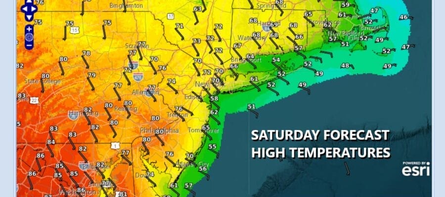
You will notice on the satellite loop below that we have clouds moving eastward from the Great Lakes and Ohio Valley but we also have clouds moving quickly westward this morning from off the ocean. This is due to the onshore flow that is setting up today with winds from the east and southeast as opposed to winds from the southwest. As a result we will see a wide range of weather conditions today ranging from mostly cloudy or even overcast in some coastal areas and partly sunny weather at times inland. Temperatures are also going to be in a wide range with 50s along the coast, and 80s along and west of the Interstate 81 corridor in Pennsylvania. Everyone else will be somewhere in between, 70s in New Jersey (except the shore) and near 70 New York City and the Hudson Valley. 60s and 50s will be common on Long Island.
SATELLITE WITH LIGHTNING STRIKES

WEATHER RADAR

No rain is forecast today but we do have a cold front arriving early Sunday so we could see showers developing during the early morning hours Sunday before daybreak and then lasting through midday before ending from west to east. Rainfall amounts will generally be a quarter of an inch or less. Then we will see clouds decrease, a northwest wind pick up and temperatures that are likely to settle in the 50s Sunday afternoon and then drop to the 30s by Monday morning.

Monday will be in stark contrast to last week’s highs in the 80s to near 90 degrees. We will have sunshine but it is going to be cold with highs just in the upper 40s and lower 50s. Then we will drop to the 20s inland Tuesday morning and low to mid 30s warmer urban and coastal areas. There will be some frost and freeze possibilities for Tuesday morning but temperatures should recover back into the 50s with sunshine Tuesday afternoon. Wednesday we could see highs back in the upper 60s to near or over 70 degrees but there will be another weather system that will pass through with perhaps a little shower risk.
BE SURE TO DOWNLOAD THE FREE METEOROLOGIST JOE CIOFFI WEATHER APP &
ANGRY BEN’S FREE WEATHER APP “THE ANGRY WEATHERMAN!
MANY THANKS TO TROPICAL TIDBITS FOR THE USE OF MAPS
Please note that with regards to any severe weather, tropical storms, or hurricanes, should a storm be threatening, please consult your local National Weather Service office or your local government officials about what action you should be taking to protect life and property.


