Dorian Nearing Virgin Islands Puerto Rico Risk Grow For SE US Florida Labor Day Weekend
A HURRICANE WARNING HAS BEEN ISSUED FOR VIEQUES…CULEBRA…AND THE
U.S. VIRGIN ISLANDS.
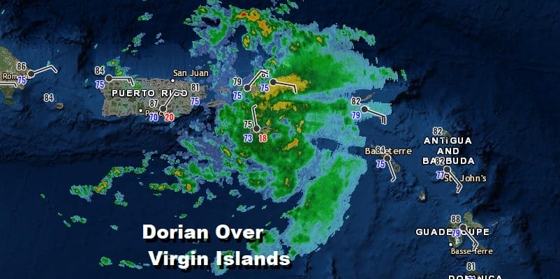
Satellite pictures and radars from Puerto Rico show Dorian nearing the islands and it has strengthened overnight. The satellite presentation this morning continues to improve from yesterday. Air Force plane reports show that the pressure has been slowly falling. The dry air at mid levels of the atmosphere continues to diminish. Dorian is moving northwestward and it looks to pass over the or close to Eastern Puerto Rico which means that the threat to the Dominican Republic has diminished while it has increased for the Virgin Islands with the track further to the west. Top winds have increased to 70 mph and Dorian could become a hurricane at any time.
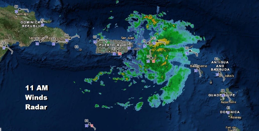
The well defined center is moving over the virgin islands as evidenced by the radar signature and the winds which are showing that counter clockwise rotation over the Virgin Islands. The storm is small in terms of coverage and the tropical storm force winds still remain in a tight area around the center of gennerally 50 miles or less.
SATELLITE

Once Dorian clears the Virgin Islands and Puerto Rico, Dorian will continue northwestward and then we will wait for a turn to the west north west. The satellite below shows Tropical Depression Erin to the northwest and off the North Carolina Coast. To the northeast there is an upper low that has created a weakness Dorian is responding to. The weakness and the earlier turn to the Northwest means the risks to the Dominican Republic have been significantly reduced.
WIDE TROPICAL SATELLITE

Now let’s move on to the track and risks going forward. A large upper high is forecast to build to the northeast of Dorian and then build westward into the Southeastern US. This will drive Dorian on a more west northwest course and that increases the risks to Florida and the Southeast US. The strength of that upper high will be key to whether Dorian heads to Central or possibly South Florida or if the ridge is weaker it drives Dorian more toward Northeast Florida or even the Georgia/South Carolina coastline.

With the upper high where it is, the Mid Atlantic and the Northeast remain protected from a hurricane barreling up the Eastern Seaboard. Our upper air winds are from the west northwest which will keep us protected from any kind of direct path toward us.
MANY THANKS TO TROPICAL TIDBITS FOR THE USE OF MAPS
Please note that with regards to any tropical storms or hurricanes, should a storm be threatening, please consult your local National Weather Service office or your local government officials about what action you should be taking to protect life and property.