
Tropical Storm Erin Heads Out to Sea
Cold Front Late Day Showers Nice Dry Thursday Friday

Overnight Tropical Storm Erin has developed from the low pressure area that has been sitting off the Southeast US Coast since last week. The satellite picture this morning shows Erin centered southeast of Cape Hatteras North Carolina. It is a weak tropical storm with top winds of 40 mph. The low level center remains separated from the main convection. To the west of Erin we have a cold front that is approaching us for later today. That front will kick Erin out to the northeast with no impact on our weather, The only impact will be to area beaches today and Thursday with some rip current risk at area beaches.
SATELLITE

Clouds are overhead today as we have made the transition into a humid and warmer air mass. However temperatures today will struggle to rise because the amount of sunshine will be limited. Highs should reach the upper 70s to lower 80s. The front is producing some showers on the regional radar in Western NY and Western Pennsylvania. That front arrives late this afternoon and evening with showers and one or two thunderstorms however we do not anticipate any severe weather from this front.
REGIONAL RADAR

Local radars are also picking up on some showers developing offshore that are moving northward and could impact Southern New England and Long Island ahead of the cold front that arrives later today.
LOCAL RADAR NEW YORK CITY

LOCAL RADAR PHILADELPHIA


There are no important changes in the weather going forward. The front moves offshore and skies clear out later tonight. Thursday will be a beautiful day of sunshine with highs in the lower 80s with low humidity. Friday we will also see sunshine with perhaps a few clouds later in the day. It will start dry and turn a little more humid later in the day with highs in the low to mid 80s.
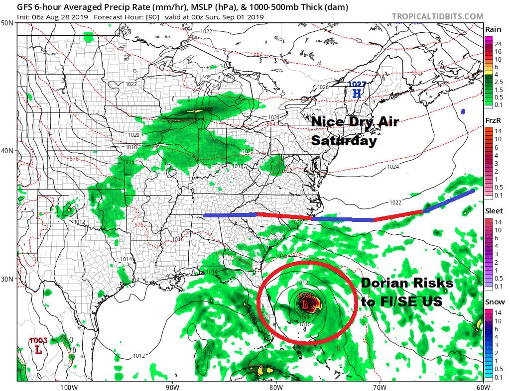
There are no changes to the outlook for the Labor Day holiday weekend. Saturday will be a beautiful day and the best of the 3 weekend days with lots of sunshine, low humidity, and highs just in the 70s. This high will be moving out to the east but unlike last week where it stalled and built back westward, this one keeps on moving. Also the onshore flow will some impact so I’m looking for clouds with some breaks of sun Sunday with the chance we could see a few passing scattered showers. Sunday’s highs in the 70s. Monday Labor Day will be more humid with clouds and some sun with the chance for a shower or a thunderstorm with highs into the 80s.

It is becoming clear that Dorian is going to be an issue this weekend for the Florida East Coast and possibly into the Southeast US Coast. Dorian will likely be a hurricane at this point though how strong remains to be seen. We continue to believe that the upper air pattern in the atmosphere is not favorable for a hurricane or tropical storm to come racing up the East Coast.
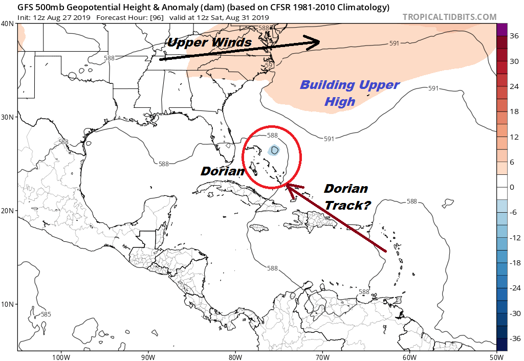
As far as where the greatest risk lies, it will depend on the upper high off the Southeast US coast. A stronger ridge drives Dorian further west while a weaker one brings Dorian closer to the North Florida coast or perhaps Georgia or South Carolina. Hurricane model track guidance has shifted northward from yesterday. We will have complete analysis of this on our Weather in 5 video as well as our live stream tonight on Youtube at 7pm. If you are on the weather app you can watch live streams and videos directly from there.
MANY THANKS TO TROPICAL TIDBITS FOR THE USE OF MAPS
Please note that with regards to any tropical storms or hurricanes, should a storm be threatening, please consult your local National Weather Service office or your local government officials about what action you should be taking to protect life and property.


