
Rip Currents At Jersey Shore Beaches
Rip Currents At Jersey Shore Beaches
With an onshore flow developing today, be advised that if you are headed to the Jersey shore today there is a moderate risk of rip currents developing. Here are the shore forecasts for various beaches from Sandy Hook to Cape May.
SURF ZONE FORECAST FOR NEW JERSEY AND DELAWARE
NATIONAL WEATHER SERVICE MOUNT HOLLY NJ
840 PM EDT SUN AUG 7 2016
.FOR THE BEACHES OF NEW JERSEY AND DELAWARE…
NJZ014-081545-
EASTERN MONMOUTH-
840 PM EDT SUN AUG 7 2016
.TOMORROW…
SKY WEATHER……… SUNNY.
HIGH TEMPERATURE…. IN THE LOWER 80S.
BEACH WINDS……… NORTHEAST WINDS AROUND 10 MPH…BECOMING
SOUTHEAST IN THE AFTERNOON.
SURF……………. 2 TO 3 FEET.
SWELL…………… SOUTHEAST SWELL AROUND 2 FEET.
DOMINANT PERIOD….. 10 SECONDS.
SURF TEMPERATURE…. 75 DEGREES.
UVI INDEX……….. 7 – HIGH.
RIP CURRENT RISK…. MODERATE. A MODERATE RISK OF RIP CURRENTS
MEANS WIND AND OR WAVE CONDITIONS SUPPORT
STRONGER OR MORE FREQUENT RIP CURRENTS. ALWAYS
HAVE A FLOTATION DEVICE WITH YOU IN THE WATER.
SWIM ONLY IN LIFE GUARDED AREAS.
LIGHTNING THREAT…. NONE.
TIDE INFORMATION…
AT BELMAR…
LOW TIDE AT 5:29 AM…
HIGH TIDE AT 12:08 PM…
LOW TIDE AT 5:53 PM…
$$
NJZ026-081545-
COASTAL OCEAN-
840 PM EDT SUN AUG 7 2016
.TOMORROW…
SKY WEATHER……… SUNNY.
HIGH TEMPERATURE…. IN THE LOWER 80S.
BEACH WINDS……… NORTHEAST WINDS AROUND 10 MPH…BECOMING
SOUTHEAST IN THE AFTERNOON.
SURF……………. AROUND 3 FEET.
SWELL…………… SOUTHEAST SWELL AROUND 2 FEET.
DOMINANT PERIOD….. 10 SECONDS.
SURF TEMPERATURE…. 77 DEGREES.
UVI INDEX……….. 7 – HIGH.
RIP CURRENT RISK…. MODERATE. A MODERATE RISK OF RIP CURRENTS
MEANS WIND AND OR WAVE CONDITIONS SUPPORT
STRONGER OR MORE FREQUENT RIP CURRENTS. ALWAYS
HAVE A FLOTATION DEVICE WITH YOU IN THE WATER.
SWIM ONLY IN LIFE GUARDED AREAS.
LIGHTNING THREAT…. NONE.
TIDE INFORMATION…
AT BARNEGAT INLET…
LOW TIDE AT 6:23 AM…
HIGH TIDE AT 12:33 PM…
LOW TIDE AT 6:44 PM…
$$
NJZ025-081545-
COASTAL ATLANTIC-
840 PM EDT SUN AUG 7 2016
.TOMORROW…
SKY WEATHER……… SUNNY.
HIGH TEMPERATURE…. IN THE LOWER 80S.
BEACH WINDS……… NORTHEAST WINDS AROUND 10 MPH…BECOMING
SOUTHEAST IN THE AFTERNOON.
SURF……………. AROUND 3 FEET.
SWELL…………… SOUTHEAST SWELL AROUND 2 FEET.
DOMINANT PERIOD….. 9 SECONDS.
SURF TEMPERATURE…. 79 DEGREES.
UVI INDEX……….. 7 – HIGH.
RIP CURRENT RISK…. MODERATE. A MODERATE RISK OF RIP CURRENTS
MEANS WIND AND OR WAVE CONDITIONS SUPPORT
STRONGER OR MORE FREQUENT RIP CURRENTS. ALWAYS
HAVE A FLOTATION DEVICE WITH YOU IN THE WATER.
SWIM ONLY IN LIFE GUARDED AREAS.
LIGHTNING THREAT…. NONE.
TIDE INFORMATION…
AT ATLANTIC CITY…
LOW TIDE AT 5:58 AM…
HIGH TIDE AT 12:10 PM…
LOW TIDE AT 6:19 PM…
$$
NJZ024-081545-
ATLANTIC COASTAL CAPE MAY-
840 PM EDT SUN AUG 7 2016
.TOMORROW…
SKY WEATHER……… SUNNY.
HIGH TEMPERATURE…. IN THE LOWER 80S.
BEACH WINDS……… NORTHEAST WINDS AROUND 10 MPH…BECOMING
SOUTHEAST IN THE AFTERNOON.
SURF……………. AROUND 3 FEET.
SWELL…………… SOUTHEAST SWELL AROUND 2 FEET.
DOMINANT PERIOD….. 10 SECONDS.
SURF TEMPERATURE…. 79 DEGREES.
UVI INDEX……….. 7 – HIGH.
RIP CURRENT RISK…. MODERATE. A MODERATE RISK OF RIP CURRENTS
MEANS WIND AND OR WAVE CONDITIONS SUPPORT
STRONGER OR MORE FREQUENT RIP CURRENTS. ALWAYS
HAVE A FLOTATION DEVICE WITH YOU IN THE WATER.
SWIM ONLY IN LIFE GUARDED AREAS.
LIGHTNING THREAT…. NONE.
TIDE INFORMATION…
AT CAPE MAY…
HIGH TIDE AT 12:06 AM…
LOW TIDE AT 6:19 AM…
HIGH TIDE AT 12:44 PM…
LOW TIDE AT 6:40 PM…
$$


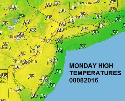
No serious weather issues are in the forecast for today or Tuesday. Look for lots of sunshine, low humidity, and temperatures in the low to middle 80s. We will begin to see temperatures and humidity start to rise beginning on Wednesday. Highs will be in the mid to upper 80s Wednesday afternoon. Thursday through Saturday highs could reach 90 to 95 in most areas. There is just a minimal threat for a thunderstorm until later Saturday when the next cold front is due to arrive. We are in middle August mode.
FiOS1 News Weather Forecast For Long Island
FiOS1 News Weather Forecast For New Jersey
FiOS1 News Weather Forecast For Hudson Valley
NATIONAL WEATHER SERVICE SNOW FORECASTS
LATEST JOESTRADAMUS ON THE LONG RANGE
Weather App

Don’t be without Meteorologist Joe Cioffi’s weather app. It is really a meteorologist app because you get my forecasts and my analysis and not some automated computer generated forecast based on the GFS model. This is why your app forecast changes every 6 hours. It is model driven with no human input at all. It gives you an icon, a temperature and no insight whatsoever.
It is a complete weather app to suit your forecast needs. All the weather information you need is right on your phone. Android or I-phone, use it to keep track of all the latest weather information and forecasts. This weather app is also free of advertising so you don’t have to worry about security issues with your device. An accurate forecast and no worries that your device is being compromised.
Use it in conjunction with my website and my facebook and twitter and you have complete weather coverage of all the latest weather and the long range outlook. The website has been redone and upgraded. Its easy to use and everything is archived so you can see how well Joe does or doesn’t do when it comes to forecasts and outlooks.
Just click on the google play button or the apple store button on the sidebar for my app which is on My Weather Concierge. Download the app for free. Subscribe to my forecasts on an ad free environment for just 99 cents a month.
Get my forecasts in the palm of your hand for less than the cost of a cup of Joe!

MENTION JOE CIOFFI AND GET A 5% DISCOUNT


