Coldest Night of the Autumn Season Warm Up Begins Thursday

Weather in 5/Joe & Joe Weather Show Latest Podcast
Coldest Night of the Autumn Season Warm Up Begins Thursday
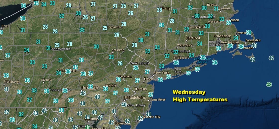
After the coldest day of the Autumn season it would be logical that it be followed by the coldest night of the winter season so far. In spite of sunshine today we had a gusty northwest wind all day long near the coast at least and temperatures did not get out of the mid and upper 30s for most of the area. This would be normal for January!
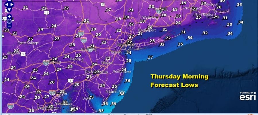
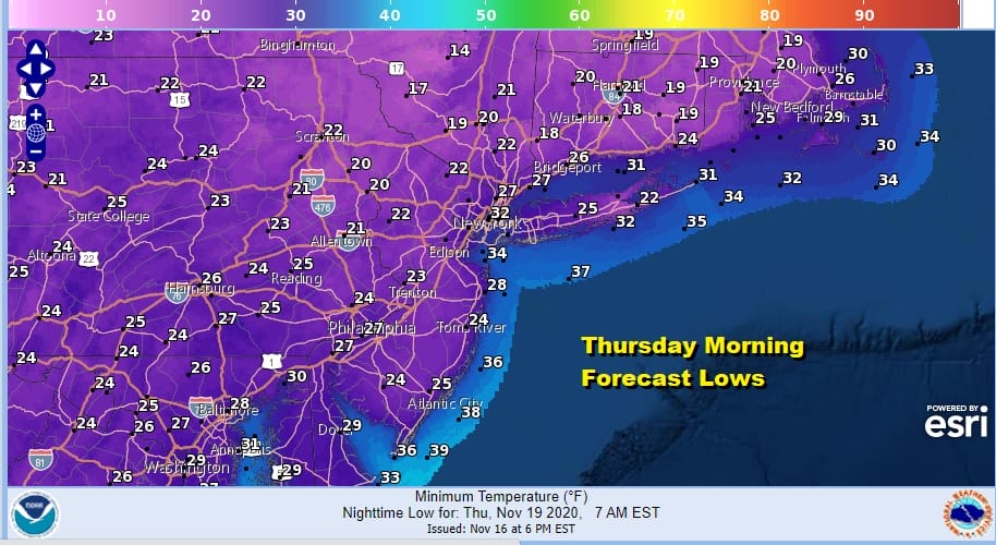
We have clear skies on the satellite picture tonight and we also have the pressure gradient finally relaxing as high pressure builds overhead. With the combination of clear skies and light winds, we should see lows by morning in many areas in the upper teens to mid 20s with only the warmer urban setting bottoming in the upper 20s by morning.
There are no issues overnight and no issues for Thursday as we will stay clear all night and we should have lots of sunshine on Thursday. The regional and local radars have gone silent and we should not have any rain worries through the daytime Saturday. Thursday’s highs will bounce from the morning lows reaching the upper 40s to some lower 50s as winds shift around to the west and west southwest as the day wears on.
SATELLITE

REGIONAL RADAR

There are no changes for the outlook for Friday and the weekend in general. We will see sunshine on Friday as temperatures head into the upper 50s and lower 60s. We may see a few clouds as a weak cold front drops southward from upstate NY Friday night but it comes through free of precipitation.

The issue for the weekend is the building high to the north and the developing onshore flow over the weekend. This will keep temperatures lower than they otherwise would be and highs for both Saturday and Sunday will be in the upper 50s and lower 60s in general. A front will temporarily stall to the west but then move eastward on Sunday. Showers will stay to the west on Sunday during the day and the area weakens as it moves eastward Sunday night into Monday. A colder high builds in for later Monday and Tuesday and models are showing a storm heading for the Great Lakes with showers likely here Wednesday but they should move out in time to salvage Thanksgiving day and Friday of next week.
BE SURE TO DOWNLOAD THE FREE METEOROLOGIST JOE CIOFFI WEATHER APP &
ANGRY BEN’S FREE WEATHER APP “THE ANGRY WEATHERMAN!
MANY THANKS TO TROPICAL TIDBITS FOR THE USE OF MAPS
Please note that with regards to any severe weather, tropical storms, or hurricanes, should a storm be threatening, please consult your local National Weather Service office or your local government officials about what action you should be taking to protect life and property.


