
Colder Air Arrives Tonight Through Monday Night,
Stormy Mid Week Showers Thunderstorms

It’s the weekend and a new month. March is a month of increasing volatility in temperatures as winter tries to hang on against the inevitable warming of spring. It is an uneven transition and that often leads to strong winds, wide temperature swings and everything from snow to thunderstorms. Today we are in the midst of one of those wide temperature swings ahead of a colder air mass. Highs to day will be in the 50s to near 60 and we will see some sunshine until an upper trough goes by late in the day.
SATELLITE WITH LIGHTNING STRIKES

WEATHER RADAR

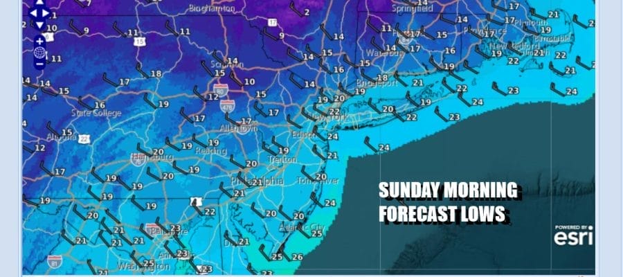
There may be another passing shower or two late this afternoon with the upper trough and then it turns windy and much colder. Skies will become mostly clear and by Sunday morning our temperatures will be some 40 degrees lower, in the mid teens to near 20 degrees. Gusty northwest winds will make it feel like it is at least 10 degrees colder.

Sunday dayside will be a day of ineffective sunshine as the core of this cold air mass heads east across the Appalachians and then eventually reaches the Mid Atlantic coast. Monday. Sunday highs will be in the low to mid 30s and by Monday morning, most lows across Eastern Pennsylvania to Southern New England will be in the teens with some single digit readings well inland.
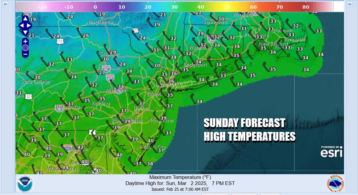
We will begin to see a moderation in temperatures starting Monday which will be a sunny day and highs will be in the 30s to around 40 degrees. The warm up continues Tuesday as we climb to the upper 40s and lower 50s. Sunshine will give way to arriving clouds ahead of the next storm system in the Central Plains that will be heading for the Great Lakes.

We will likely see some rain Tuesday night into Wednesday morning as a warm front moves northward. Once that passes as temperatures rise, so will the southerly wind ahead of a cold front. We will then see some downpours and perhaps a thunderstorm or two late Wednesday into Wednesday night. The Storm Prediction Center in it’s long range is indicating elevated risk for severe weather reaching New Jersey but that will depend on the warm front getting by and sometimes they do get hung up and struggle to move north. Wednesday temperatures will reach the mid 50s to lower 60s and then we drop again and dry out for the end of next week.
BE SURE TO DOWNLOAD THE FREE METEOROLOGIST JOE CIOFFI WEATHER APP &
ANGRY BEN’S FREE WEATHER APP “THE ANGRY WEATHERMAN!
MANY THANKS TO TROPICAL TIDBITS FOR THE USE OF MAPS
Please note that with regards to any severe weather, tropical storms, or hurricanes, should a storm be threatening, please consult your local National Weather Service office or your local government officials about what action you should be taking to protect life and property.


