Cold Winter Pattern Breaks Down Over the Weekend & Next Week

Cold Winter Pattern Breaks Down Over the Weekend & Next Week

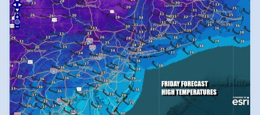
The storm system over the Northeast that brought rain snow and wind is moving through Southeastern Canada and continuing to march to the east. Cold air is overhead today and we will see a fair amount of sunshine. It will remain breezy however and temperatures in general will top out in the low to middle 30s except from South Jersey southward where highs will reach the mid to upper 30s. Snow showers over the Great Lakes are diminishing and Lake Effect and Winter Storm Warnings are limited to a handful of counties in Southwestern NY, NW Pennsylvania as well as parts of Central NY. These should all expire later today.
SATELLITE WITH LIGHTNING STRIKES

WEATHER RADAR

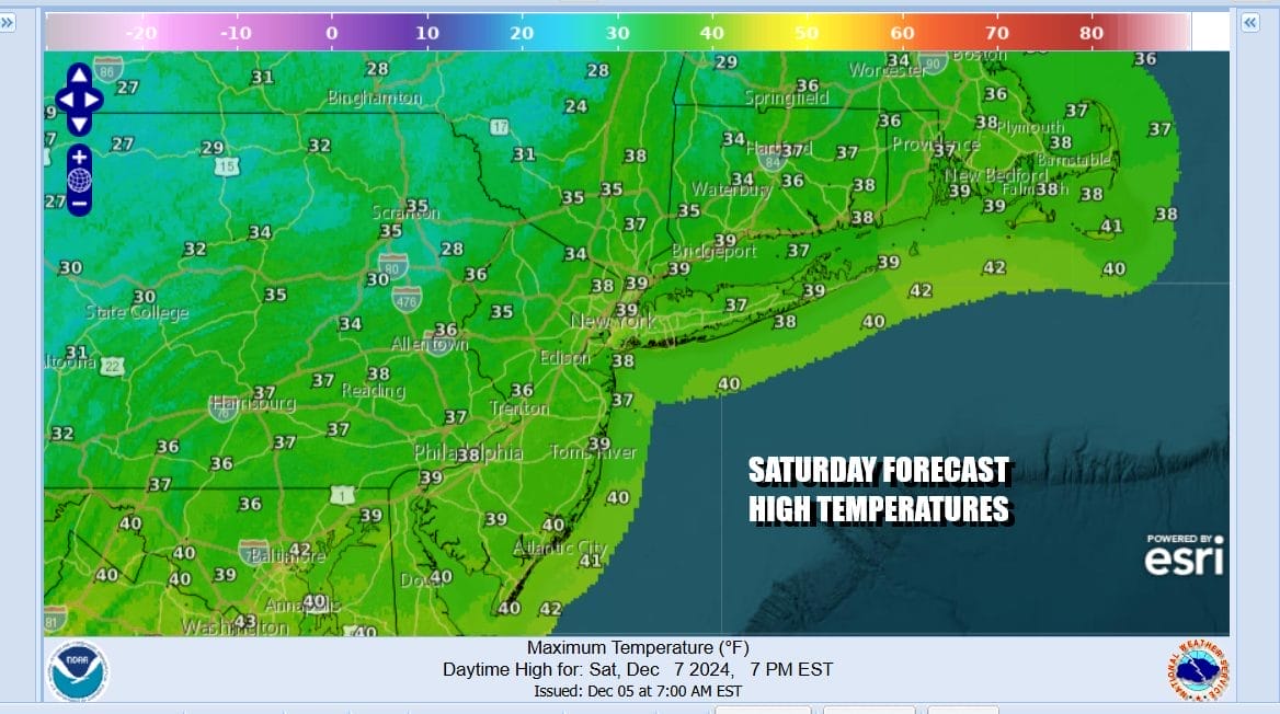
Tonight skies should be mostly clear with lows by morning across Eastern Pennsylvania in the upper teens to mid 20s. Saturday we will see temperatures inch a little higher with sunshine giving way to some arriving high clouds. Highs will be in the middle to upper 30s. The high clouds are running ahead of a warm front that will pass through Saturday night into early Sunday morning.
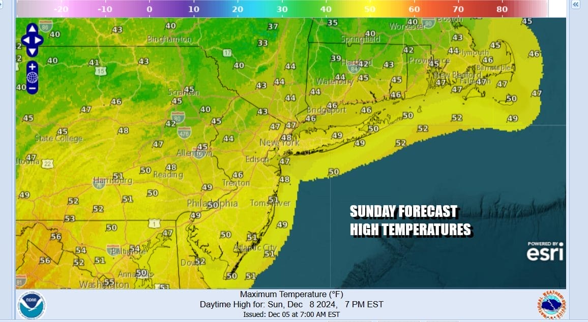
As the warm front passes it could produce a few snow showers mainly north and northeast of NYC overnight into Sunday morning. Temperatures probably won’t be moving much overnight as winds shift to the west and milder air comes in for Sunday. Clouds early Sunday morning will give way to some sunshine. Highs Sunday afternoon will reach the upper 40s and even some lower 50s.
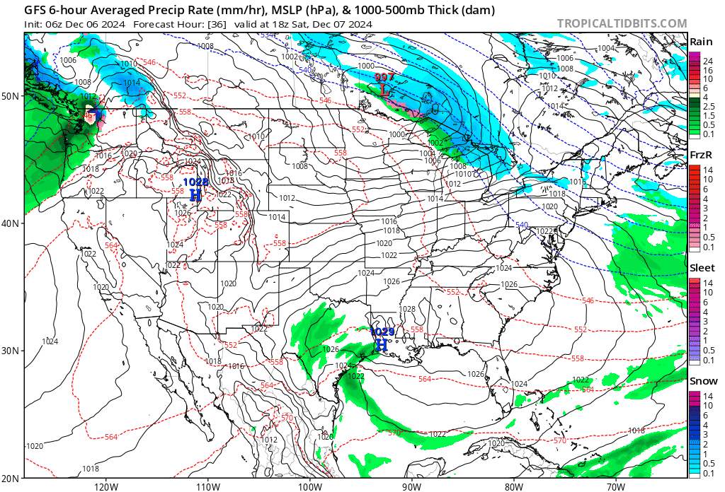
We are transitioning to a warmer weather pattern as the flow from Canada is cut off and the upper air flow is more west to east. This limits cold air entering the US from the north. It will also open up opportunities for rain next week. The first such chance comes from a weak Gulf Coast low that will move northward Monday, bringing a period of rain or showers through sometime during the day Monday and into Monday night. Monday temperatures will be in the upper 40s and lower 50s.
The first wave goes by and even warmer air will be moving in for Tuesday and Wednesday. A stalled frontal boundary just inland of the East Coast will keep things rather cloudy Tuesday and Wednesday and we will probably see a more significant rain later Wednesday into Wednesday night. We stand a solid cahnce of picking up an additional inch and a half to 2 inches of rain to help cut the rain deficit.Temperatures could reach the mid 50s to lower 60s midweek before colder air returns at the end of the week.
BE SURE TO DOWNLOAD THE FREE METEOROLOGIST JOE CIOFFI WEATHER APP &
ANGRY BEN’S FREE WEATHER APP “THE ANGRY WEATHERMAN!
MANY THANKS TO TROPICAL TIDBITS FOR THE USE OF MAPS
Please note that with regards to any severe weather, tropical storms, or hurricanes, should a storm be threatening, please consult your local National Weather Service office or your local government officials about what action you should be taking to protect life and property.


