Cold Weather All Week Snow Shower Chances Along the Way
Record Breaking Lake Effect Snow Continues

Cold Weather All Week Snow Shower Chances Along the Way
Record Breaking Lake Effect Snow Continues
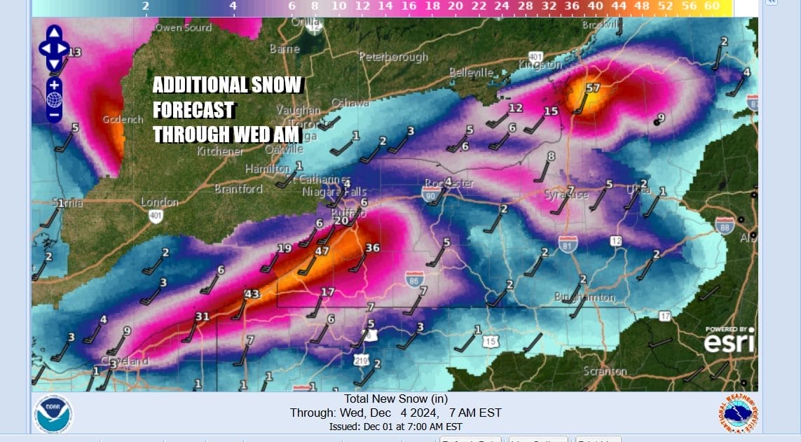
Today is the 3rd day of record breaking “Lake Effect” snows for Upstate NY, NW Pennsylvania and Northeast Ohio. Insane snow amounts have fallen with some places in Erie County PA and the Southwestern Counties of NY measuring 50 to 60 inches so far. It is not impossible that some of these areas could see triple digit snow amounts before this is all said and done. Lake Ontario and Lake Erie water temperatures were well above average going into this and that has increase the amount of moisture the surrounding air can hold and eventually release. Satellite loops and regional radars continue to show patches of snow moving onshore and this will last into Tuesday. The “lake effect” snow machine will take a brief pause before firing up again later this week. Snow areas will shift to areas east of Buffalo NY and potentially bringing heavy snows to cities like Rochester and Syracuse NY among others.
SATELLITE WITH LIGHTNING STRIKES

WEATHER RADAR

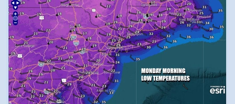
Meanwhile across the coastal plain which includes Eastern Pennsylvania to Southern New England very cold air for this time of year has arrived and taken a firm grip on the area. Today we will see partly sunny skies along with a chilly northwest wind and high temperatures that will struggle to get out of the 30s. Under mainly clear skies tonight, most lows will be in the mid and upper teens inland and low to middle 20s coast and warmer urban locations.

The week ahead will be colder than average temperature wise all week long and probably through next weekend. As far as weather systems are concerned we are in a pattern where the northwest flow will bringing systems diving southeastward from South Central Canada and into the Great Lakes and Northeast. It seems that most of these systems will track to the north and they should be light precipitation producers.

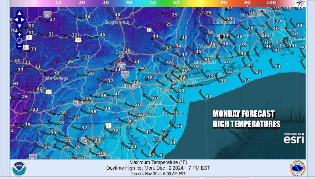
Ahead of the first system which would be for Wednesday night into Thursday, we see cold days and nights for Monday and Tuesday. Both days will see temperatures starting out in the upper teens to mid 20s and then with sunshine, highs will only make it back to the 30s to perhaps near 40 in some of warmest urban areas.
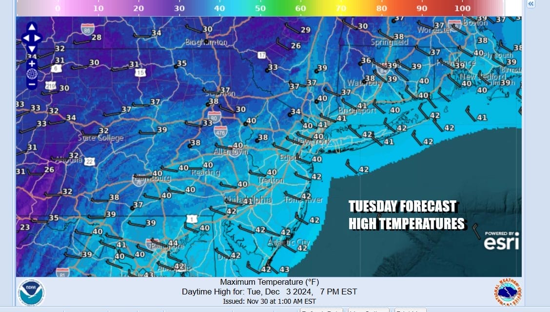
Wednesday we see sunshine to start but then clouds will increase and that will hold temperatures down in the 30s for highs. Wednesday night into Thursday as the first diver moves by to the north, some rain showers are possible along the immediate coast and some snow showers are possible inland. Thursday could be a little warmer after the precipitation is done with highs back into the 40s especially near the coast. Then another shot of very cold air comes in for Friday and Saturday with highs both days only in the 30s. Another diver will bring another chance for rain or snow showers next Sunday.
BE SURE TO DOWNLOAD THE FREE METEOROLOGIST JOE CIOFFI WEATHER APP &
ANGRY BEN’S FREE WEATHER APP “THE ANGRY WEATHERMAN!
MANY THANKS TO TROPICAL TIDBITS FOR THE USE OF MAPS
Please note that with regards to any severe weather, tropical storms, or hurricanes, should a storm be threatening, please consult your local National Weather Service office or your local government officials about what action you should be taking to protect life and property.


