
Cold Start to the Week Ahead Midweek Rain Thunderstorms
& Perhaps Some Severe Weather
Yesterday we saw some of the warmest temperatures we have seen since back in November. Today we are back in the icebox. Cold air came in one big rush Saturday afternoon and we settled this morning in the teens to near 20. Needless to say this is a very cold Sunday of sunshine, gusty winds and most highs only in the low to mid 30s. We don’t expect much to happen today other than perhaps some patchy clouds from time to time.
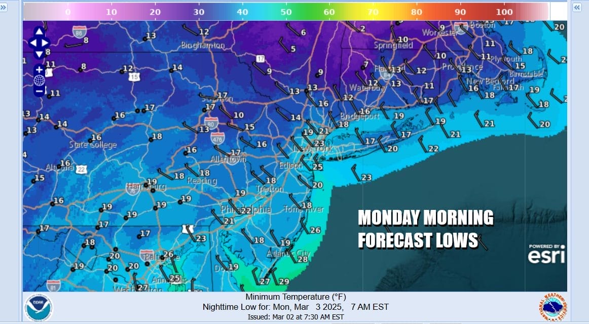
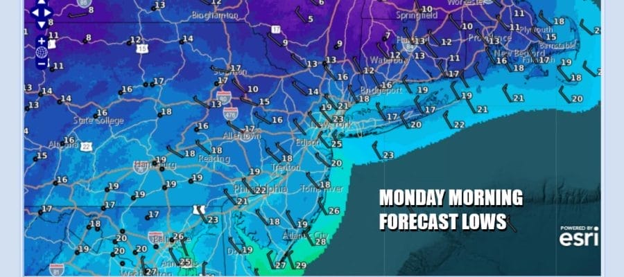
The core of this cold air mass will be overhead tonight so under clear skies and a bit of a breeze, at least early tonight, lows by Monday morning will be in the teens to near 20 degrees and some cold spots well inland in the Hudson Valley could see lows in the single digits. Winds should drop off as the night wears on.
SATELLITE WITH LIGHTNING STRIKES

WEATHER RADAR

The weather focus this week will be on a developing storm system in the Central Plains that will be heading to the Great Lakes. This system looks like a typical early spring season storm system and that means that we will likely see an impressive early season severe weather outbreak across the Deep South Tuesday and in the Southeast US Wednesday. This also comes with elevated tornado risk both days.

The Storm Prediction Center is indicating that the slight risk for severe thunderstorm could reach as far north as Southern New Jersey but the dynamics of this system and the strength of the cold front suggest that severe weather could extend further north Wednesday into the Hudson Valley and Northern New Jersey.

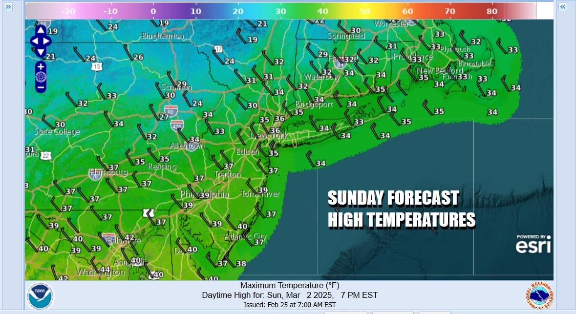
Ahead of all this we have the core of the cold air mass moving out Monday and that will leave us with a sunny day. After a bitter cold morning start highs will reach the upper 30s to some lower 40s. Monday night won’t be nearly as cold. Tuesday we look ahead to sunshine giving way to some late day arriving clouds. Tuesday highs will reach the upper 40s to lower 50s especially away from the immediate coast.

More clouds move in Tuesday night into Wednesday as a warm front moves northward. We expect rain to develop ate Tuesday night or by Wednesday morning daybreak at the lates. Then we will have showery rains with some heavy downpours, a gusty south to southwest wind, and the risk for a thunderstorm or two until a cold front passes late in the day Wednesday or Wednesday evening.
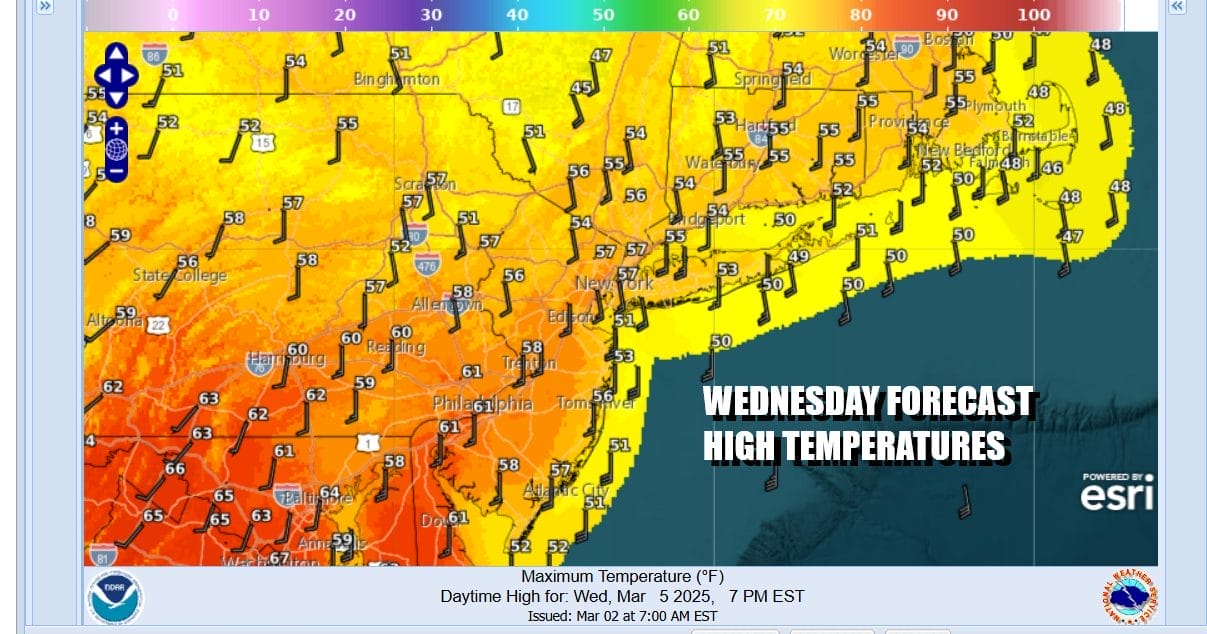
High temperatures Wednesday will be pushing through the 50s and even some 60s are possible in areas across Southern New Jersey and Southern Pennsylvania southward. Once the front passes we should see improving weather conditions for Thursday into Friday as it turns cooler but not especially cold and weather conditions in general calm down.
BE SURE TO DOWNLOAD THE FREE METEOROLOGIST JOE CIOFFI WEATHER APP &
ANGRY BEN’S FREE WEATHER APP “THE ANGRY WEATHERMAN!
MANY THANKS TO TROPICAL TIDBITS FOR THE USE OF MAPS
Please note that with regards to any severe weather, tropical storms, or hurricanes, should a storm be threatening, please consult your local National Weather Service office or your local government officials about what action you should be taking to protect life and property.


