Cold Into Monday Chance Rain Snow Showers Tonight Weekend & Thanksgiving Week Outlook
We have arrived at another weekend and while Western and North Central NY and NW Pennsylvania continue to be hammered by non stop lake effect snow, we have seen a good deal of sunshine. It is cold though as highs this afternoon will be in the low to mid 40s. We do have an upper trough that will be moving through this evening and that could trigger off a rain or snow shower. Once that trough passses skies should partially clear overnight with morning lows in the 20s to around 30 degrees.
SATELLITE

WEATHER RADAR

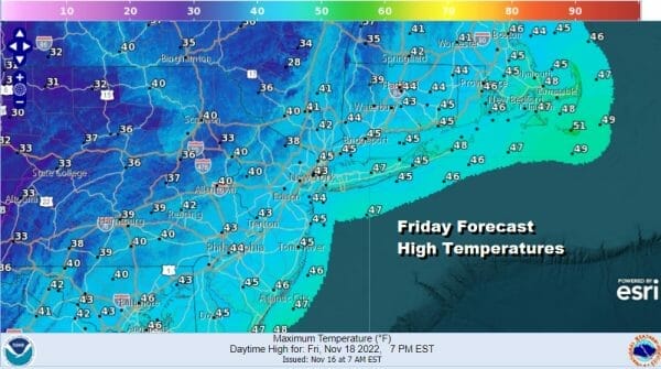
Moving on to the weekend it will be breezy and it will be cold with some sunshine for both Saturday and Sunday. The complex series of upper troughs will continue to move across the Great Lakes and Northeast so the lake effect snows continue. We will not have to worry about any of that as the air is dry and everything snow wise is pinned back north and west of the Catskills. Highs Saturday will be in the upper 30s inland and lower 40s in warmer urban and coastal areas.
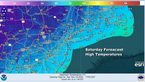
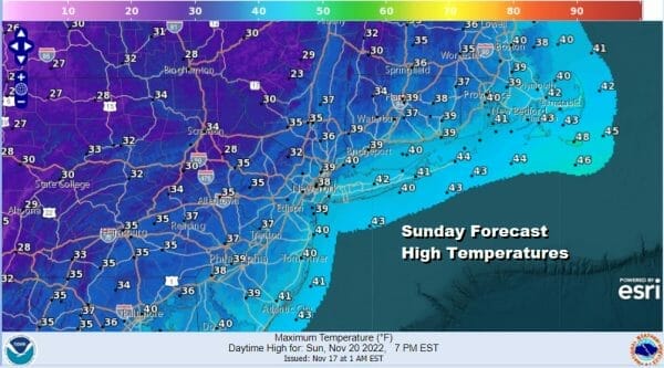
The coldest air will be coming in Saturday night through Sunday night. Lows Sunday morning will be in the 20s. Sunday is the coldest day of this stretch with sunshine, a gusty wind and highs just in the 30s to around 40 at best. Then we will be down in the 20s by Monday morning.
The core of the cold air starts to move out on Monday but while we will see temperatures moderate next week into Thursday Thanksgiving Day, it won’t be much of a warm up. It will be dry through at least Thursday so we do not see any weather issue for travelers heading to or away for Thanksgiving. Monday sees sunshine with highs back into the 40s. We will see some sun Tuesday and Wednesday with highs both days in the upper 40s to some lower 50s.
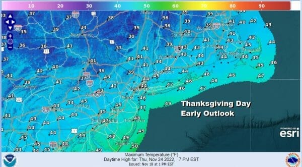
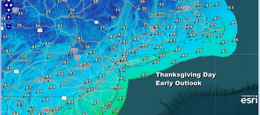
It will be trending colder Thanksgiving day with sunshine and arriving clouds. High pressure will be strengthening in Eastern Canada and building down the East Coast. Meanwhile energy droping from Canada to the Eastern Lakes transfers to the Carolinas where a storm will develop and move northeast and then possibly northward, at least in the world of the European model. We continue to think that we will see more model volatiltiy ahead so nothing is etched in stone at this point. However we do see a chance for a storm that will bring rain and snow to the Mid Atlantic and Northeast and who gets what will depend on how strong of a block develops over Greenland and Northeast Canada. We probably won’t have this completely figured out until early next week. Until then enjoy the rest of your day and the weekend.
BE SURE TO DOWNLOAD THE FREE METEOROLOGIST JOE CIOFFI WEATHER APP &
ANGRY BEN’S FREE WEATHER APP “THE ANGRY WEATHERMAN!
MANY THANKS TO TROPICAL TIDBITS & F5 WEATHER FOR THE USE OF MAPS
Please note that with regards to any severe weather, tropical storms, or hurricanes, should a storm be threatening, please consult your local National Weather Service office or your local government officials about what action you should be taking to protect life and property.


