Cold Front Brings Chilly Dry Air For Columbus Day Weekend
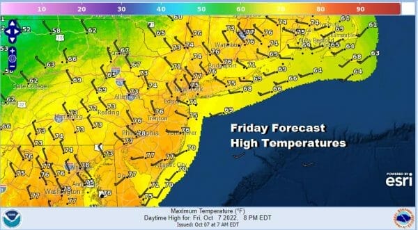
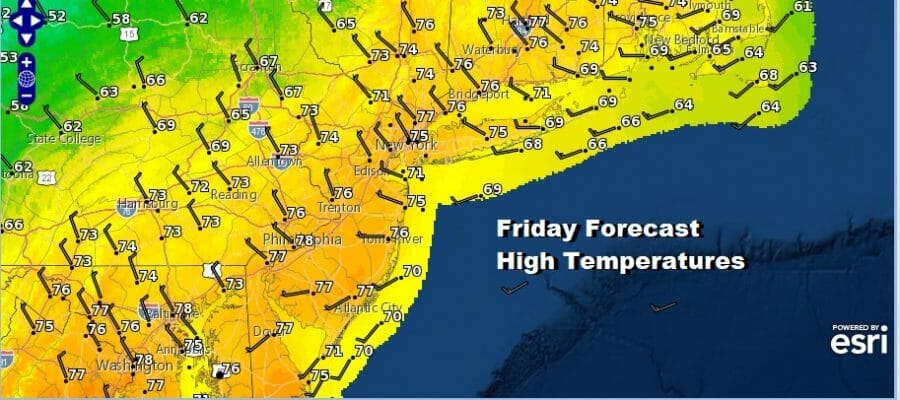
We have arrived at the end of the work week and after a lovely Thursday of sunshine and highs back into the low 70s, we are going to see partly sunny to mostly cloudy skies today as a cold front approaches from the west. Clouds with that cold front will move through but there isn’t much in the way of rain with this front and just about all the shower activity on the radar is well up to the northwest in Western and Northern New York and Northern New England. Winds will shift to the northwest this afternoona nd most highs will be in a range of 70 to 75 degrees.
SATELLITE

WEATHER RADAR

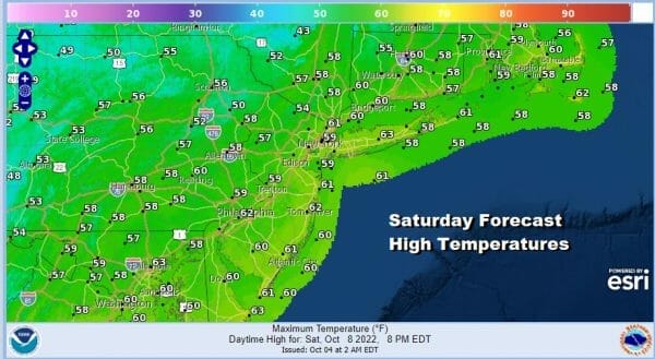
Once the front goes by, skies will clear out tonight with most lows in the 40s. Th i tere is a weak upper trough that will move through overnight with a few clouds during the early morning hours but they should be mostly gone by morning. Saturday looks like a nice day of sunshine with a few clouds in the mix. Highs Saturday will be mostly in the 50s.
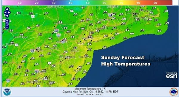
Sunday sees the core of the dry air mass moving to the Mid Atlantic states and that leaves us in a day of lots of sunshine. Highs Sunday will reach back into the 60s in most places. Overall it is a nice autumn weekend. It is also a holiday weekend with Monday being Columbus Day and it should be a nice day with no worse than partly sunny skies. Monday highs will reach the mid to upper 60s.

Next week we will see a quiet first half with dry conditions and no worse than partly sunny skies Tuesday and Wednesday. High temperatures Tuesday and Wednesday will reach 65 to 70 degrees both days. Thursday we will see a cold front approach and it will be the one day where we will see some showers later in the day. Highs will be in the 60s to near 70 Thursday.

We have seen a very cool start to the autumn season. We also are seeing that cool pattern getting stronger going forward and after Thursday we look to begin an extended stretch of below average temperatures that will carry us through the middle of the month of October and that pattern might continue beyond that timeframe.
BE SURE TO DOWNLOAD THE FREE METEOROLOGIST JOE CIOFFI WEATHER APP &
ANGRY BEN’S FREE WEATHER APP “THE ANGRY WEATHERMAN!
MANY THANKS TO TROPICAL TIDBITS & F5 WEATHER FOR THE USE OF MAPS
Please note that with regards to any severe weather, tropical storms, or hurricanes, should a storm be threatening, please consult your local National Weather Service office or your local government officials about what action you should be taking to protect life and property.


