Cold Air Has Returned For The Next Several Days Chance of Snow Late Weekend?

Cold Air Has Returned For The Next Several Days Chance of Snow Late Weekend?
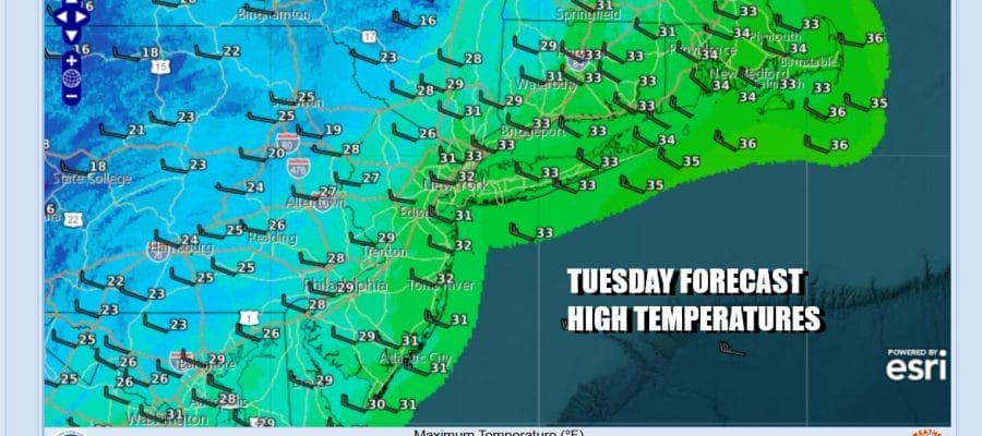
A cold front moved offshore last night and colder air has arrived. Also we will see winds pick up again for the next couple of days from the northwest. They will be running 15 to 20 mph with gusts of 30 mph at times especially along the coast. This will make temperatures feel about 10 degrees colder than what thermometers are reading. Skies should be no worse than partly sunny today. Highs will generally be in the upper 20s and lower 30s. Actually this will be one of those days where the high temperature is leftover from overnight. Nothing much is going on radar wise though we do have lake effect snows once again in North Central and Southwestern NY as well as Northwestern Pennsylvania.
SATELLITE WITH LIGHTNING STRIKES

WEATHER RADAR

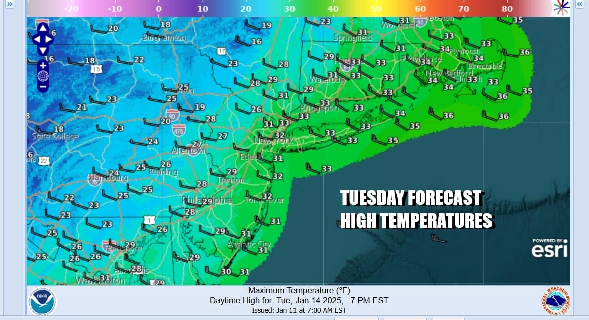
A cold and breezy night lies ahead under mainly clear skies. Lows will be in the mid to upper teens inland and low to mid 20s along the coast. Wednesday looks to be a partly to mostly sunny day. Temperatures will be topping out in the upper 20s and lower 30s once again with gusty winds making it feel colder.
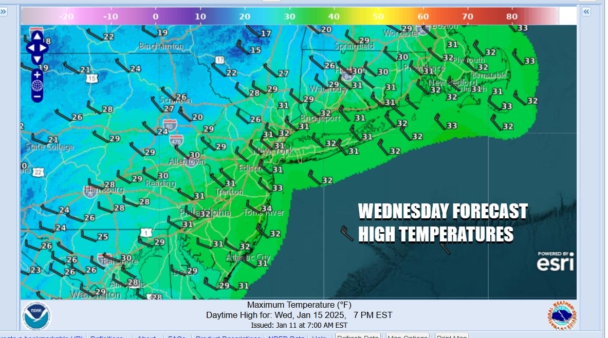
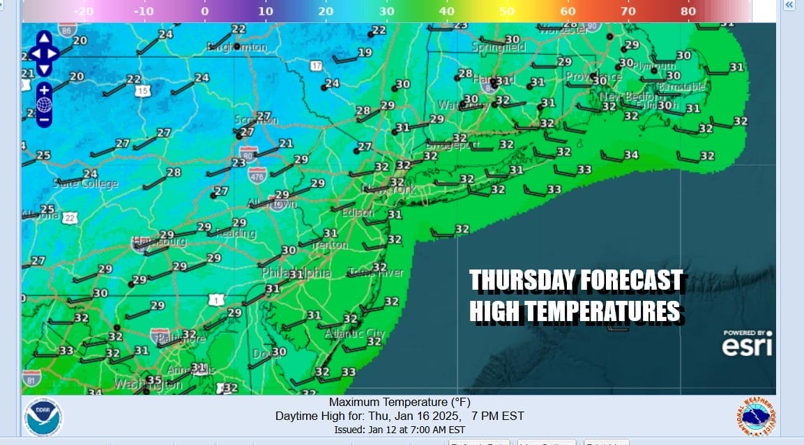
Thursday will be another cold day and there will be a weak upper trough that will be passing through during the day. This may produce a few more clouds but there still should be a fair amount of sunshine. We are going to throw in the possibility of a few scattered snow showers as the trough passes but they will be few and far between. Once again highs will be in the upper 20s and lower 30s.
The core of the cold air will move out to the east Friday and that should allow for lighter winds and warmer temperatures. After a cold start Friday morning we will see sunshine and a few clouds. Highs will reach the upper 30s and lower 40s. A cold front will be approaching Saturday. The front won’t have much to work with so we are thinking there will be a few rain showers in the afternoon and evening and not much more. Temperatures Saturday will be in the 40s.

The front is likely to stall offshore and in the Southeast US as it appears likely that a wave will develop on the front. Across the Great Lakes, Ohio Valley and Northeast we see a very cold air mass spreading east and southward. It does seem that the wave will be the mechanism to pull cold air into the Northeast next week. The question is whether there is enough energy to force a significant wave development as the low tracks northeastward to off the Maryland/Delaware coast. While it appears that we could see some snow developing later Sunday into Sunday night, it does not appear to be something that strengthens and gets out of hand. For now we will put in the chance for some snow late Sunday into Sunday night with the usual caveats about weaker tracks further south, etc etc. Next week looks to be very cold for much if not all of next week for just about everyone east of the Rockies including the Deep South.
BE SURE TO DOWNLOAD THE FREE METEOROLOGIST JOE CIOFFI WEATHER APP &
ANGRY BEN’S FREE WEATHER APP “THE ANGRY WEATHERMAN!
MANY THANKS TO TROPICAL TIDBITS FOR THE USE OF MAPS
Please note that with regards to any severe weather, tropical storms, or hurricanes, should a storm be threatening, please consult your local National Weather Service office or your local government officials about what action you should be taking to protect life and property.


