
Coastal Flood Watch New Jersey Long Island
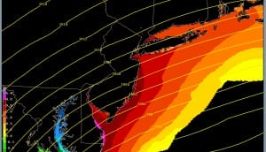
Coastal Flood Watch New Jersey Long Island posted for Saturday. 2 high tide cycles are at risk and the picture above will take you to the Ocean Prediction Center where you can loop the forecast surge. The forecast has improved slightly since yesterday as the maximum surge being shown is 3 to 4 feet up and down the New Jersey Coat and Western Long Island Sound. This is down one foot from yesterday. However this could change as the storms position adjusts. Coastal flooding could be moderate to heavy however even with the surge levels down 1 foot in the forecast. I would advise to bookmark and check this from time to time as this is a handy tool to have.
Coastal Flood Watch New Jersey Long Island

You can see the developing storm now on the satellite loop as it moves across the Gulf states and heads to the southeast US coast. It will be off the Delmarva Peninsula during Saturday.
Coastal Flood Watch New Jersey Long Island
.NEW JERSEY COASTAL WATERS STORM WATCH IN EFFECT FROM LATE FRIDAY NIGHT THROUGH SUNDAY MORNING…
Synopsis: HIGH PRESSURE BUILDING OVER THE MIDDLE ATLANTIC TONIGHT GRADUALLY RETREATS NORTHWARD DURING THE DAY FRIDAY. MEANWHILE, LOW PRESSURE TRACKING ACROSS THE GULF STATES WILL REDEVELOP ALONG THE CAROLINA COAST FRIDAY NIGHT, AND RAPIDLY INTENSIFY AS IT MOVES SLOWLY TO THE NORTHEAST OFF THE VIRGINIA CAPES ON SATURDAY. AS THE LOW MOVES AWAY ON SUNDAY, HIGH PRESSURE WILL BUILD IN BRIEFLY ON MONDAY, FOLLOWED BY A COLD FRONT ON TUESDAY. HIGH PRESSURE MOVES IN FROM THE SOUTHWEST FOR THE MIDDLE OF NEXT WEEK.
Synopsis: CANADIAN HIGH PRESSURE BUILDS IN FROM THE WEST TONIGHT AND THEN SLOWLY RETREATS TO THE NORTHEAST INTO THE WEEKEND. A COASTAL LOW TRACKS OFF THE MID ATLANTIC COAST FRIDAY NIGHT…THEN SLOWLY TRACKS TO THE SOUTH…THEN SOUTHEAST OF LONG ISLAND THROUGH SUNDAY. HIGH PRESSURE RETURNS SUNDAY NIGHT THROUGH MONDAY BEFORE MOVING OFFSHORE MONDAY NIGHT INTO TUESDAY. A FRONTAL SYSTEM WITH AN ASSOCIATED WARM FRONT APPROACHES BY TUESDAY.
NATIONAL WEATHER SERVICE SNOW FORECASTS
LATEST JOESTRADAMUS ON THE LONG RANGE
Weather App

Winter is here! Don’t be without Meteorologist Joe Cioffi’s weather app. It is a complete weather app to suit your forecast needs. All the weather information you need is right on your phone. Android or I-phone, use it to keep track of all the latest weather information and forecasts. This weather app is also free of advertising so you don’t have to worry about security issues with your device. An accurate forecast and no worries that your device is being compromised.
Use it in conjunction with my website and my facebook and twitterand you have complete weather coverage of all the latest weather and the long range outlook. The website has been redone and upgraded. Its easy to use and everything is archived so you can see how well Joe does or doesn’t do when it comes to forecasts and outlooks.
Just click on the google play button or the apple store button on the sidebar for my app which is onMy Weather Concierge. Download the app for free. Subscribe to my forecasts on an ad free environment for just 99 cents a month.
Get my forecasts in the palm of your hand for less than the cost of a cup of Joe!

![]()