
Coastal Flood Watch Long Island New Jersey Sunday & Monday
Cold Returns Gusty Winds Highs 30s Rain Chance Waits Until Monday
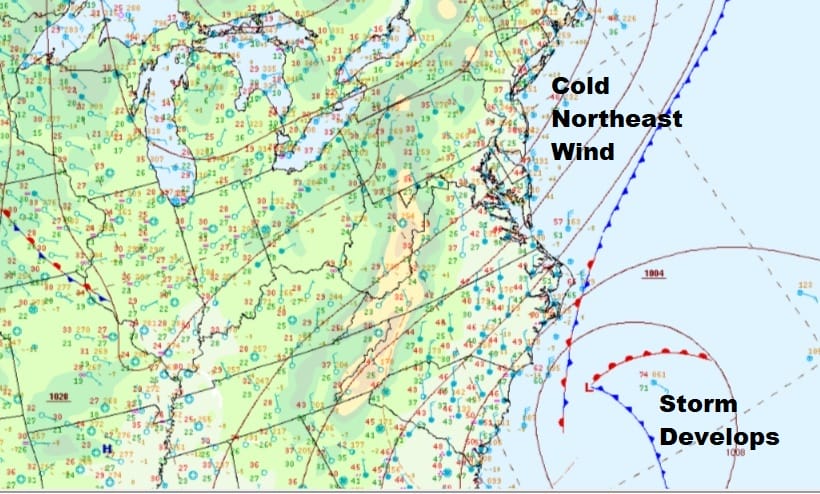
A new dry cold high has arrived from Canada so the temperature bounce of the last 2 days has come to an end. We do have clear skies across the Northeast and in the Northern Middle Atlantic States. To the south this morning we have our major coastal storm sitting off the North Carolina Coast. The high itself is interacting with the low off the coast to create a somewhat tight pressure gradient. Gusty northeast winds and temperatures in the 30s will make for a rather cold Saturday though at least we will see plenty of sunshine. Radars are quiet both regionally and locally. In fact the rain from the Carolina Coastal Storm has moved out of range at least for the time being.
SATELLITE

REGIONAL RADAR

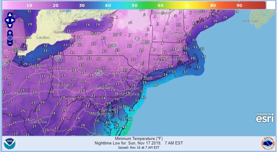
The strong high in Southeast Canda/New England will make for a cold night in the Northeast and that cold air drains south into the Northern Middle Atlantic states tonight. Skies should be mostly clear with the cloud line probably somewhere just south of Washington DC/Baltimore tonight. It will be breeze with a Hudson Valley wind (North Northeast) and that is typically how we see very cold temperatures here. Lows in upstate NY will go below zero in some places with teens to low 20s nearby NYC. Warmer urban centers will like bottom in the upper 20s and lower 30s.
COASTAL FLOOD WATCH SUNDAY INTO MONDAY LONG ISLAND NEW JERSEY
Higher than normal tides are an issue beginning today with Coastal Flood Advisories up with today’s high tides However a more serious tidal concern develops for Sunday into Monday high tides for Long Island and New Jersey. Coastal Flood Watch is posted for the potential for moderate coastal flooding and beach erosion from this coastal storm off the Carolinas combined with the strong high pressure to the north.
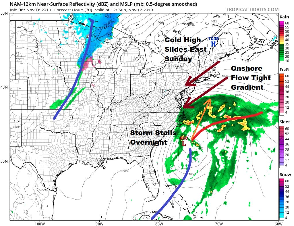
The low will begin moving northeastward Sunday so we will see clouds increasing and thickening up though no rain is forecast into Sunday night so the day will be dry. Highs will be in the upper 30s and lower 40s. Sunday night into Monday the low will head toward Cape Cod and should be close enough to produce some rain from New Jersey to Southern New England later Sunday night and on Monday along with some gusty winds.
While all this is going in there is the coastal flooding concern. Sunday into Monday provides the greatest risk for moderate coastal flooding until the low comes even with our latitude and then heads into the Gulf of Maine. Winds will start to shift to the north late Monday or Monday night which should cause tidal issues to abate.
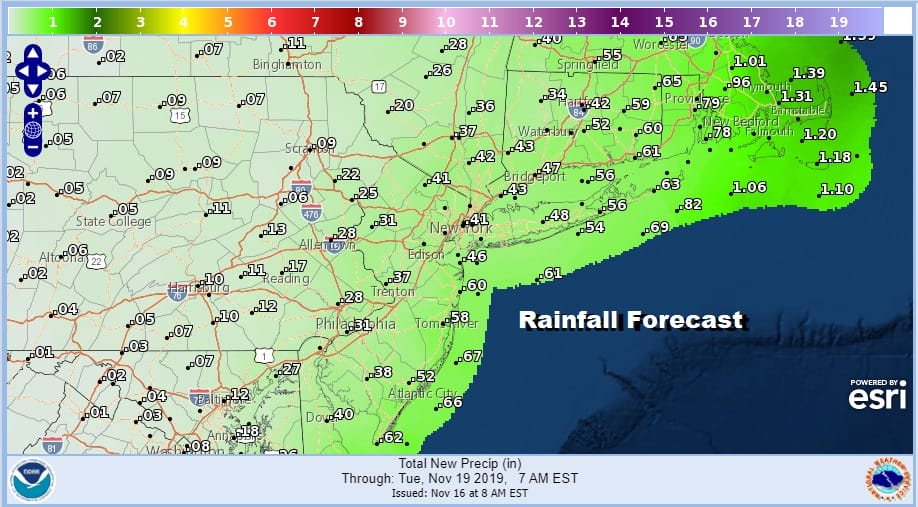
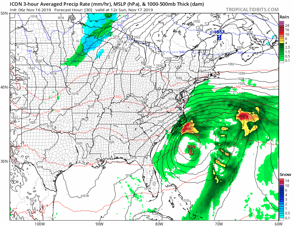
As far as rainfall is concerned, the low tracking along or east of 70 Degrees West toward Cape Cod keeps us out of the heavy rain and puts in more showery rains coming in from off the ocean Sunday night into Monday night. It looks like rainfall amounts should be generally under a half inch with inland amounts a quarter of an inch or less. Weather conditions will improve on Tuesday as the low heads toward Nova Scotia. Clouds and some sunshine are forecast for Tuesday with highs in the chilly 40s.
BE SURE TO DOWNLOAD THE FREE METEOROLOGIST JOE CIOFFI WEATHER APP &
ANGRY BEN’S FREE WEATHER APP “THE ANGRY WEATHERMAN!
MANY THANKS TO TROPICAL TIDBITS FOR THE USE OF MAPS
Please note that with regards to any severe weather, tropical storms, or hurricanes, should a storm be threatening, please consult your local National Weather Service office or your local government officials about what action you should be taking to protect life and property.


