Cloudy Rainy Sunday Late Shower Thunderstorm Monday Humidity Drop Follows
We are seeing low pressure developing along the coast today and it has brought northward an expanding area of rain that will be with us pretty much all day long and into this evening in some areas. We haven’t seen many days like this over the summer but August usually starts to bring a few of these kind of days where we have a high to the northeast providing us with an onshore low. Add a short wave trough lifting northeast with a surface low and you have the set up for a rather gray rainy day with temperatures probably staying in the 60s while it is raining.
SATELLITE

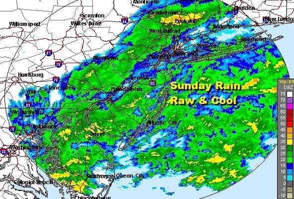
REGIONAL RADAR

Embedded in the overall area of rain is a band of moderate to heavy rain running this morning from Southeast Pennsylvania northeastward into Northern New Jersey. Local radars are loaded up.
LOCAL RADAR NEW YORK CITY

LOCAL RADAR PHILADELPHIA


Amazingly the short termp weather models have been just awful with this. When what is going on radar wise doesn’t match up with the models, it is the models that are wrong and not reality. Some weather folks haven’t quite grasped on to this concept.

Once the low pulls away to the northeast, weather conditions will improve with rain ending from west to east tonight. We should see some sunshine on Monday but there is a weak front that will move through late in the day so we will throw in the chance for a shower or thunderstorm. Highs will be in the upper 70s and lower 80s.

For the second time this month we are seeing a very strong trough setting up in the Eastern US. Actually the overall set up in the atmosphere would be something that winter weather loves would go bonkers for as every technical measure of the upper atmosphere would be make for very cold and snowy conditions in the winter. In the summer the payoff is some nice weather with deep blue skies and low humidity and that is where we are headed for Tuesday and Wednesday. Highs both days will be in the upper 70s to lower 80s. We should see a good deal of sunshine on Tuesday and a mix of sun and clouds for Wednesday because the upper trough will be nearby and there will be a stalled frontal boundary across the Middle Atlantic states. It should not pose a big issue other than clouds but we will be watching. Longer range sees the trough in the east ridge in the west strengthening which means all the heat is in the west and we keep seeing cold fronts every 2 to 3 days. 90 degree plus days should be few and far between going forward.
BE SURE TO DOWNLOAD THE FREE METEOROLOGIST JOE CIOFFI WEATHER APP &
ANGRY BEN’S FREE WEATHER APP “THE ANGRY WEATHERMAN!
MANY THANKS TO TROPICAL TIDBITS FOR THE USE OF MAPS
Please note that with regards to any severe weather, tropical storms, or hurricanes, should a storm be threatening, please consult your local National Weather Service office or your local government officials about what action you should be taking to protect life and property.


