Blowtorch Weather Next Three Days Brutal Heat Humidity & Severe Weather Risks

Blowtorch Weather Next Three Days Brutal Heat Humidity & Severe Weather Risks

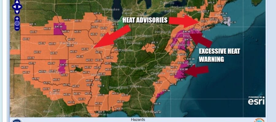
We are in the throws of a very hot, very humid air mass setting up across much of the Northeast and Mid Atlantic states. The next three days we will see high temperatures well up into the 90s and some places will probably break 100 degrees. The best chances for that will be in Southern Pennsylvania, Central & South Jersey (away from the ocean) south to Maryland, Delaware, and Virginia. Highs will be mostly in the low to middle upper 90s from NYC north and east. Humidity levels remain off the wall high with dew points near 70. We will watch for the possibility of thunderstorms popping up this afternoon and evening in some places though most of the area probably won’t see much of anything. Heat Advisories and Excessive Heat Warnings are up and are likely to stay up through Wednesday.
SATELLITE WITH LIGHTNING STRIKES

WEATHER RADAR

The next major change in the weather pattern across the Great Lakes, Ohio Valley, Northeast and Mid Atlantic states will come along midweek. Weak upper air disturbances are rolling along in the northwest flow aloft so they can set off thunderstorms late today as well as late Tuesday. Most of the severe weather risk is north and northwest of the coast today and extends back westward into the Ohio Valley.

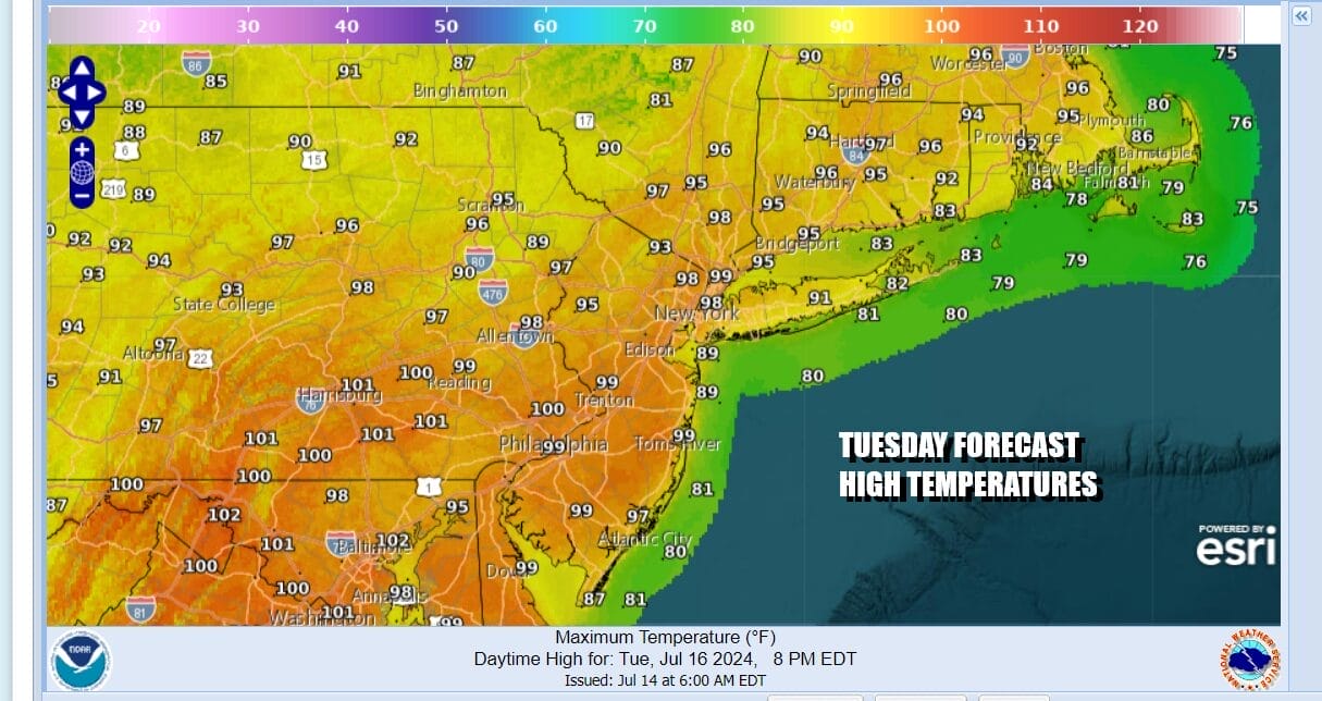
Tuesday will be the hottest of the next 3 days. We might also see a couple of thunderstorms running around especially late in the day in Tuesday evening. Highs will reach 100 degrees or higher over areas from Central and South Jersey and points south and southwest. Temperatures around NYC and the Hudson Valley will reach the mid and upper 90s. Low to mid 90s will be common north and east across Southern New England and Long Island. Heat indices will reach 100 to as high as 110 in some places. The highest heat indices will probably be centered around urban areas like Philadelphia, Washington DC, and Baltimore.
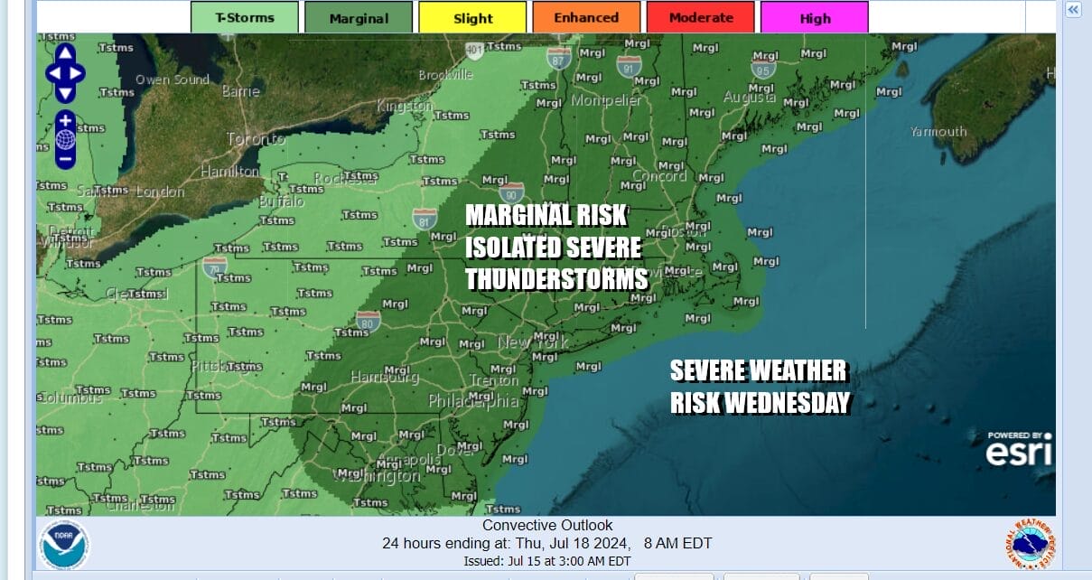
Wednesday will be the last very hot day because as the GFS model loop shows above, we have a cold front that will be approaching and this front will successfully move through. Ahead of it we will see sunshine, very hot, and very humid conditions with highs in the mid to upper 90s. Then late in the day a line of thunderstorms is likely to develop across Pennsylvania and Upstate NY and push eastward.
We expect his line of storms to extend further south into the Mid Atlantic states and we will see severe weather risk that extends from Maine southward to Southeastern Virginia. For now the Storm Prediction Center, in it’s first outlook forecast for Wednesday is indicating a marginal risk for isolated severe thunderstorms. I would not be surprised to see this outlook upgraded in the coming days.
Once the front passes we will finally get a break in the heat and, more importantly, a break in the humidity which has been running very high for many days. Dry air from a Canadian air mass will build in Thursday and we will see clouds giving way to developing sunshine. Highs will be in the 80s. Friday will be another day of sunshine and comfortable humidity levels. Highs again will be in the 80s.
BE SURE TO DOWNLOAD THE FREE METEOROLOGIST JOE CIOFFI WEATHER APP &
ANGRY BEN’S FREE WEATHER APP “THE ANGRY WEATHERMAN!
MANY THANKS TO TROPICAL TIDBITS FOR THE USE OF MAPS
Please note that with regards to any severe weather, tropical storms, or hurricanes, should a storm be threatening, please consult your local National Weather Service office or your local government officials about what action you should be taking to protect life and property.
(Amazon is an affilate of Meteorologist Joe Cioffi & earns commissions on sales.)


