
Beautiful Friday, Weekend Sees Thunderstorm & Severe Weather Risk Sunday

Beautiful Friday, Weekend Sees Thunderstorm & Severe Weather Risk Sunday

The last weekend of June is upon us and we have a beautiful getaway Friday. This is definitely the best weather day of this week. A dry air mass covers the Northeast and Northern Mid Atlantic states today leaving us in a sunny place with low dew points and humidity levels. Temperatures this afternoon will be mostly in a range of 80 to 85 degrees. Radars are nice and quiet and we have no weather issues to worry about today. Tonight will be nice and clear with most lows in the upper 50s inland and low to mid 60s coast and warmer urban locations.
SATELLITE WITH LIGHTNING STRIKES

WEATHER RADAR

The weekend sees an approaching cold front however the timing of this front is such that the dayside Saturday will be dry with no rain. It will also be quickly turning more humid as the day wears on. Dew points will be rising through the 60s to near 70 by the end of the day. Most highs Saturday will be in the middle to upper 80s with cooling sea breezes at the beaches of Long Island, New Jersey and Southeastern New England.

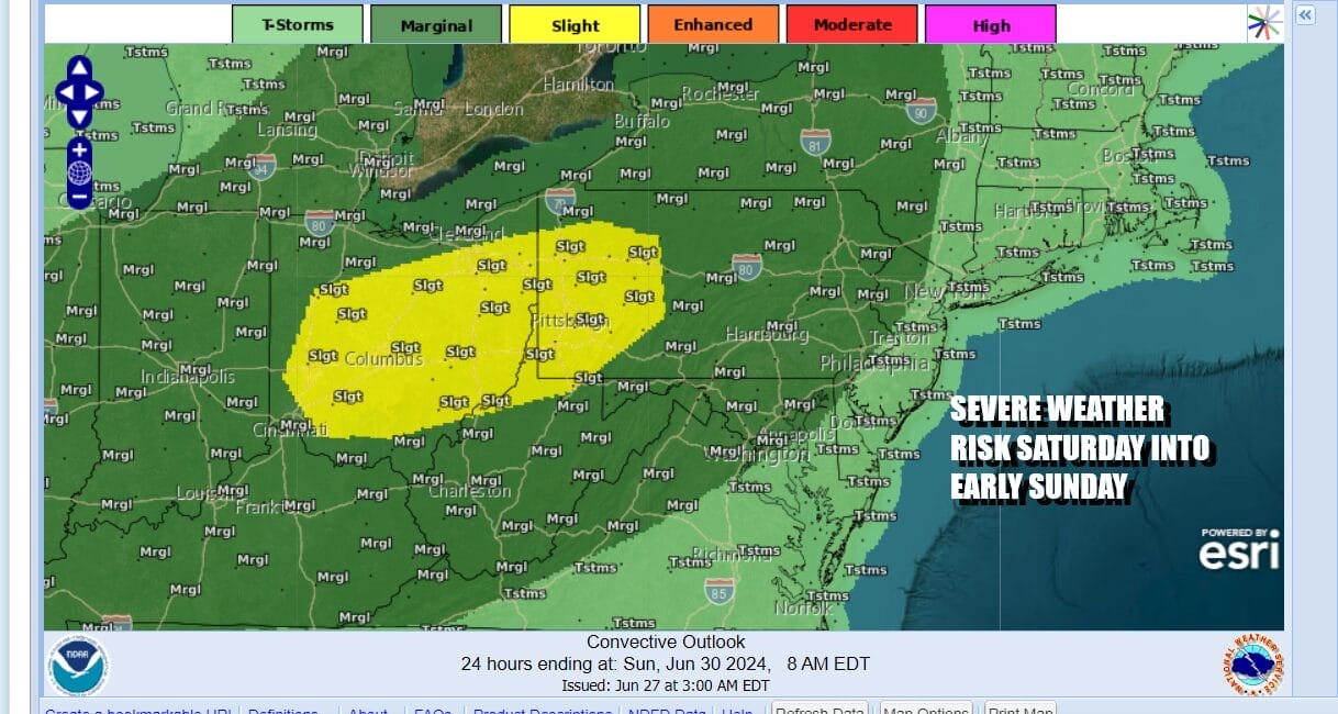
We do have a cold front approaching along with a strong upper trough approaching for Satutrday night and Sunday. This opens the door to some renegade thunderstorms developing in a few scattered locations Saturday evening. The Storm Prediction Center has a marginal risk for severe weather (isolated severe thunderstorms) across Pennsylvania into Northwest New Jersey.
The front is going to slow down and wait for the upper trough moving across the Great Lakes and this is going to set up Sunday as a hot and very humid day with sunshine taking highs into the 90s in many locations. Winds will be more west than south so coastal areas and beaches will also see temperatures near 90 degrees.
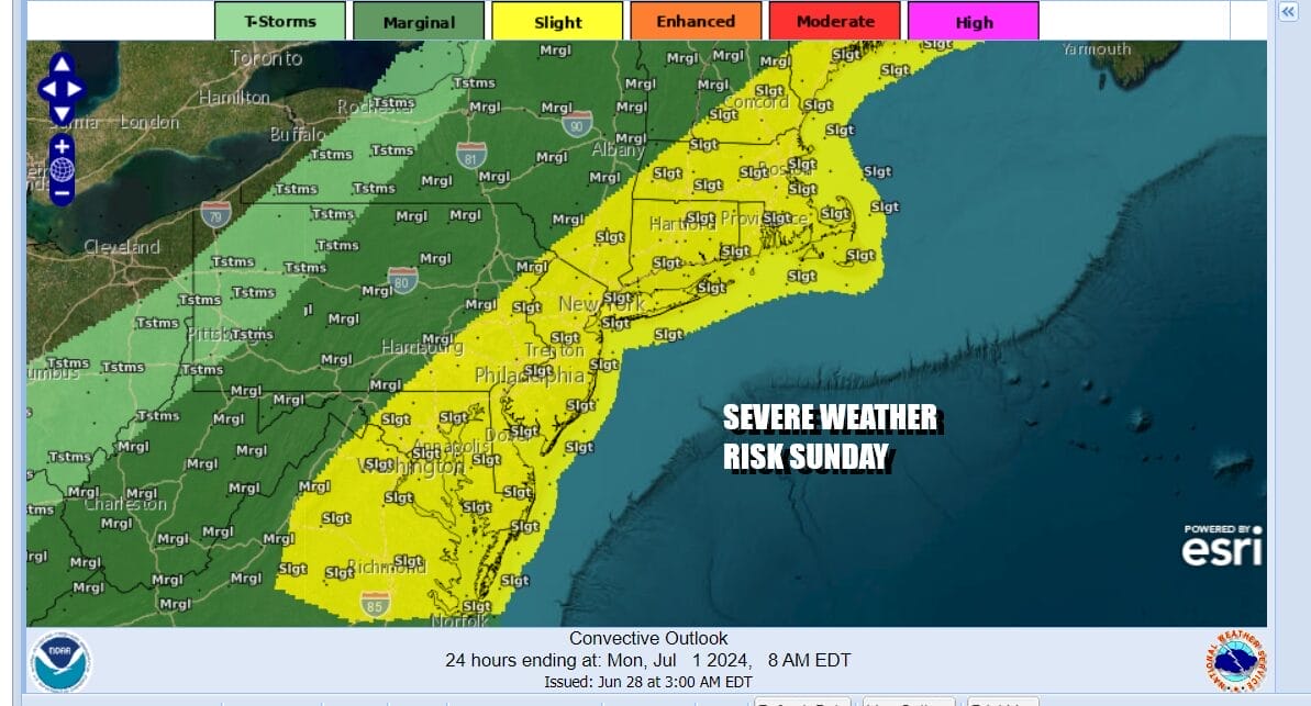
The front will approach and pass through late Sunday and Sunday evening. The hot unstable air mass plus favorable dynamics lead to severe weather risk for later Sunday into Sunday night. The Storm Prediction Center has indicated a slight risk (15%) for severe weather. Showers and thunderstorms will pass though and that will be followed by yet another dry air mass for early next week.

Next week is a big vacation week as we head to Thursday, the 4th of July holiday. Monday and Tuesday will be two very nice days of low humidity and sunshine. Monday highs will be in the upper 70s and lower 80s. Tuesday highs will be in the low to mid 80s. Wednesday it turns very warm and more humid but it will still be rain free with highs in the mid to upper 80s. Thursday the 4th of July looks to be a hot and humid day with sunshine and perhaps the chance for a downpour or a thunderstorm with highs back into the 90s.
BE SURE TO DOWNLOAD THE FREE METEOROLOGIST JOE CIOFFI WEATHER APP &
ANGRY BEN’S FREE WEATHER APP “THE ANGRY WEATHERMAN!
MANY THANKS TO TROPICAL TIDBITS FOR THE USE OF MAPS
Please note that with regards to any severe weather, tropical storms, or hurricanes, should a storm be threatening, please consult your local National Weather Service office or your local government officials about what action you should be taking to protect life and property.
(Amazon is an affilate of Meteorologist Joe Cioffi & earns commissions on sales.)


