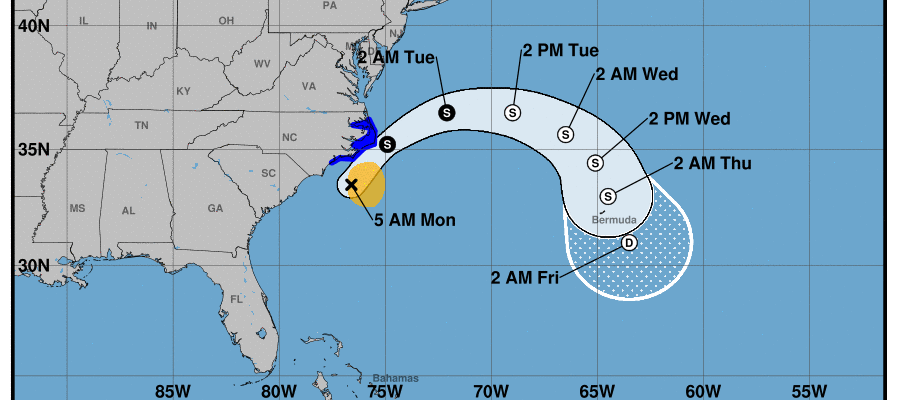
Arthur Nears North Carolina Coast Will Turn East Tonight & Tuesday

Tropical Storm Arthur hasn’t change much in strength overnight. Top winds remain around 45 mph those strong winds are east of the center while the heaviest rain is to the west of the center. Those rain bands are on the North Carolina coast. Our satellite picture this morning shows Arthur as an elongated area of clouds with a concentration of rain and thunderstorms near the circulation center.
SATELLITE

We have two local radar views; one from Morehead City, North Carolina and the other from Wakefield Virginia. Both are showing rain circulating back westward on the coast. Rain fall totals of several inches are possible before this is all said and done. Arthur should start to pull away to the northeast later today and then turn to the east overnight and Tuesday and that should put an end to the rain from this storm. Note that none of this is going to make it much further north than the Delmarva Peninsula and it is certainly not going to have any impact here.
LOCAL RADAR MOREHEAD CITY NORTH CAROLINA

LOCAL RADAR WAKEFIELD VIRGINIA


SUMMARY OF 500 AM EDT…0900 UTC…INFORMATION
———————————————-
LOCATION…33.5N 76.6W
ABOUT 85 MI…135 KM S OF MOREHEAD CITY NORTH CAROLINA
ABOUT 135 MI…215 KM SSW OF CAPE HATTERAS NORTH CAROLINA
MAXIMUM SUSTAINED WINDS…45 MPH…75 KM/H
PRESENT MOVEMENT…NNE OR 20 DEGREES AT 14 MPH…22 KM/H
MINIMUM CENTRAL PRESSURE…1002 MB…29.59 INCHES
SUMMARY OF WATCHES AND WARNINGS IN EFFECT:
A Tropical Storm Warning is in effect for…
* Surf City to Duck NC
* Pamlico and Albemarle Sounds
A Tropical Storm Warning means that tropical storm conditions are
expected somewhere within the warning area, in this case within the
next 12 to 24 hours.
For storm information specific to your area, including possible
inland watches and warnings, please monitor products issued by your
local National Weather Service forecast office.
DISCUSSION AND OUTLOOK
———————-
At 500 AM EDT (0900 UTC), the center of Tropical Storm Arthur was
located near latitude 33.5 North, longitude 76.6 West. Arthur is
moving toward the north-northeast near 14 mph (22 km/h). A turn
toward the northeast with an increase in forward speed is expected
later today, followed by a turn toward the east on Tuesday. On the
forecast track, the center of Arthur will approach the coast of
North Carolina during the next few hours, and then move near or
just east of the coast of North Carolina later today. Arthur is
then forecast to turn away from the east coast of the United
States tonight and Tuesday.
Maximum sustained winds are near 45 mph (75 km/h) with higher gusts.
While some strengthening is forecast during the next 48 hours,
Arthur is likely to lose its tropical characteristics on Tuesday
Tropical-storm-force winds extend outward up to 90 miles (150 km)
mainly to the east of the center. The Cherry Point Marine Corps
Air station recently reported a wind gust of 39 mph (63 km/h).
The estimated minimum central pressure is 1002 mb (29.59 inches).
BE SURE TO DOWNLOAD THE FREE METEOROLOGIST JOE CIOFFI WEATHER APP &
ANGRY BEN’S FREE WEATHER APP “THE ANGRY WEATHERMAN!
MANY THANKS TO TROPICAL TIDBITS FOR THE USE OF MAPS
Please note that with regards to any severe weather, tropical storms, or hurricanes, should a storm be threatening, please consult your local National Weather Service office or your local government officials about what action you should be taking to protect life and property.