Another Gloomy Night And Tuesday Late Week Zeta Rains Colder Air Looms Snow Chances Inland

Weather in 5/Joe & Joe Weather Show Latest Podcast
Another Gloomy Night And Tuesday Late Week Zeta Rains Colder Air Looms Snow Chances Inland
Another cloudy gloomy misty day has gone by and we have another night of low clouds and some patchy dense fog around. The satellite picture shows nothing but clouds covering the Northeast and Great Lakes. Some breaks are showing up well south in the Delmarva Peninsula southward into Virginia and the Carolinas. Lows will be in the lower 50s along the coast and 40s inland.
SATELLITE

REGIONAL RADAR

There could be a few spotty sprinkles as they are showing up every so often on the regional and local radars. The radars won’t pick up any areas of light rain or drizzle that could develop overnight.
LOCAL RADAR NEW YORK CITY

LOCAL RADAR PHILADELPHIA


Rolling along to Tuesday I don’t expect much change. We will have lots of clouds around. There might be some brightening of skies Tuesday and perhaps even a break or two of sun is possible but clouds will dominate with highs in the 50s. Wednesday might be the one day this week where the sun comes back for a time. We will lean partly sunny with highs in the upper 50s and lower 60s.
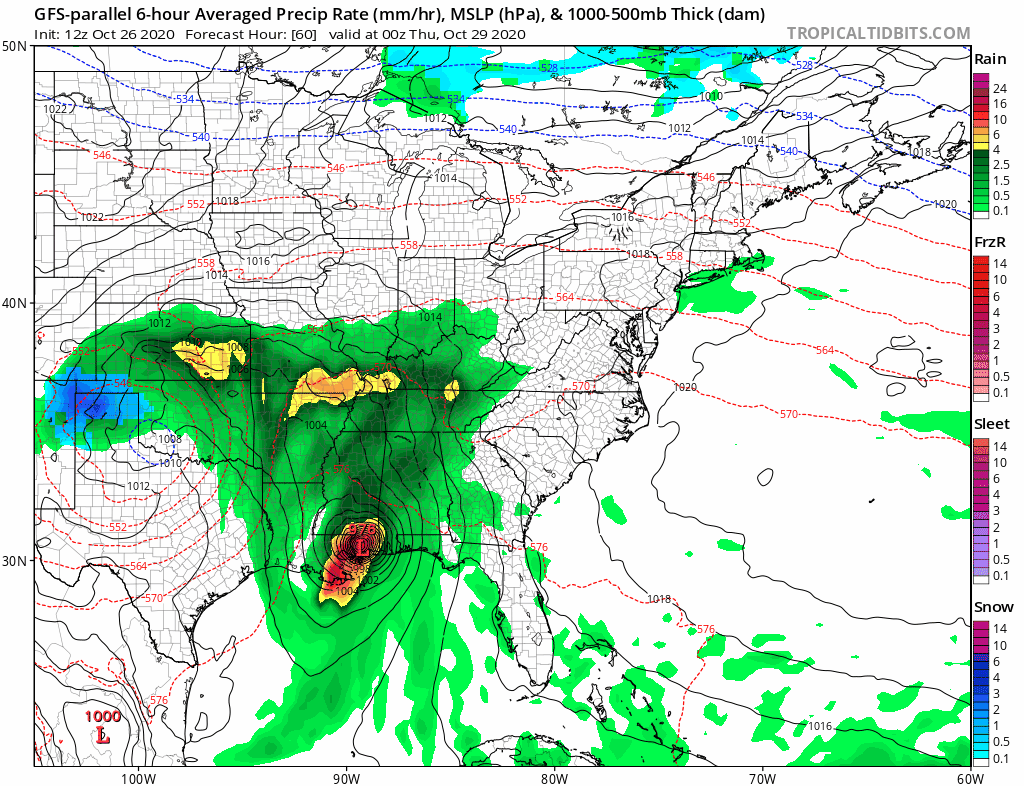
Thursday into Friday night we see a long duration event. There are two parts to this. First is Hurricane Zeta which continues to strengthen. Top winds are 80 mph and Hurricane Warnings are up for Southeast Louisiana for a landfall late Wednesday. The remnant low of Zeta accelerates rapidly to the northeast and it will be interacting with a strong upper trough that will be swinging through the Great Lakes.

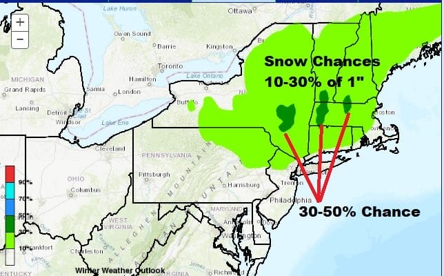
This sets us up for a soaking rain for Thursday and Thursday night from Eastern Pennsylvania to Southern New England southward. What complicates this is a second low which is a storm now bringing snow and ice to the Southern Rockies and Southern Plains. If that second lows maintains its identity it will bring a cold rain Friday on a northeast wind. Cold air is being dragged southward behind the low and as the GFS loop shows above, we have a change to wet snow for many areas inland and some accumulating snow is not out of the question north of Route 84 in the Hudson Valley, the Catskills and then east into Connecticut and points north.
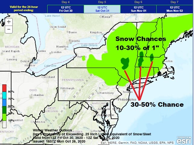
Weather Prediction Center folks seem impressed enough to at least show the southern edge of 10 to 30% chance of at least an inch down as far south as Northeast Pennsylvania and Northwest New Jersey. It isn’t too shabby a prediction in the day 5 time frame for late October. What every happens it could turn quite cold here with many areas down at 32 or less come Saturday morning as the storm system departs and weather conditions improve, leaving us with a chilly but dry nice weekend with..yes..some sunshine.
BE SURE TO DOWNLOAD THE FREE METEOROLOGIST JOE CIOFFI WEATHER APP &
ANGRY BEN’S FREE WEATHER APP “THE ANGRY WEATHERMAN!
MANY THANKS TO TROPICAL TIDBITS FOR THE USE OF MAPS
Please note that with regards to any severe weather, tropical storms, or hurricanes, should a storm be threatening, please consult your local National Weather Service office or your local government officials about what action you should be taking to protect life and property.


