
A Mostly Quiet Weekend Rain Sunday Night & Monday Morning
Ahead of Cold Front

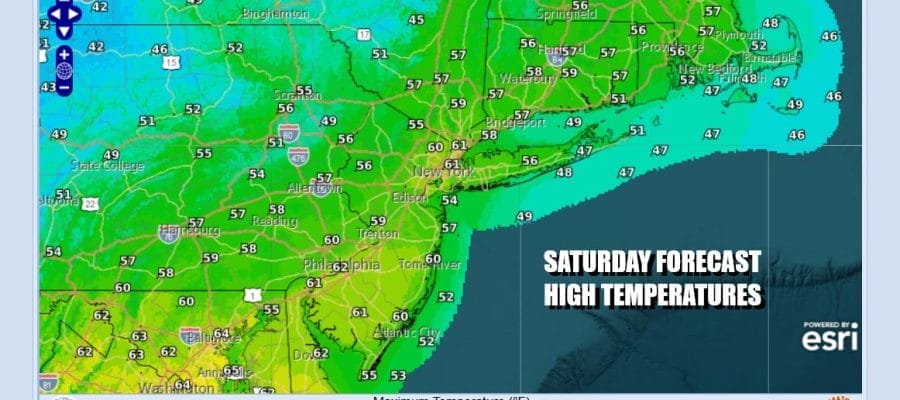
The weekend begins and we have a weak weather system that is moving out of the Great Lakes and across the Northeast today with a trailing cold front. There is some moisture with this as evidenced on the radar loops and satellites. However it is minimal and we should see most of the day as a mix of sun and clouds. During the afternoon there is the chance for a scattered rain shower or two but not much more. Highs today will be mostly in the upper 50s and lower 60s.
SATELLITE WITH LIGHTNING STRIKES

WEATHER RADAR

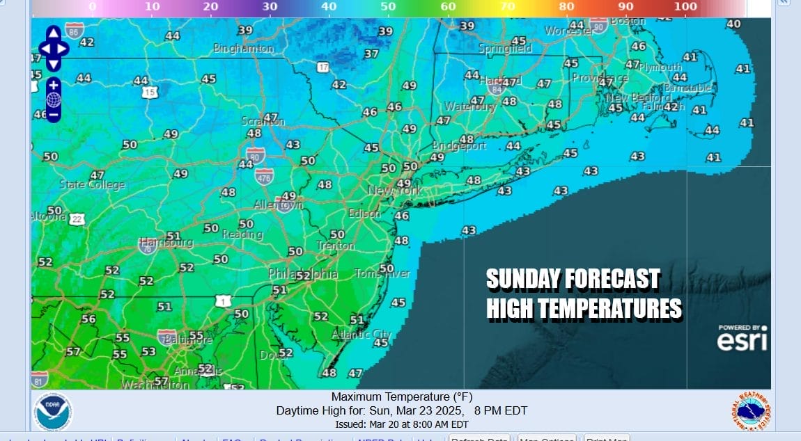
Colder air will be coming in tonight on northwest winds behind the front. Skies will be mostly clear. It might be a little breezy at times and Sunday morning lows will be in the upper 20s and lower 30s. Sunday will be a quiet day which will start with sunshine but then it will give way to arriving clouds. High temperatures Sunday afternoon will be in the chillier upper 40s and lower 50s.
Low pressure moving into the Pacific Northwest today will be taking a track straight eastward across Northern Plains and to the Great Lakes Sunday and then from there it will move into Southeastern Canada/Northern New England Sunday night into Monday. There will be snow with that low along and north of the low track and an area of rain or showers to the south with a trailing cold front.

You can expect some rain to develop Sunday night from west to east and then the rain will end from west to east during Monday morning. This will not be a big rain producer as we expect mostly a quarter to a half inch with slightly higher amounts possible over Southern and Southeastern New England as well as Eastern Long Island. Weather conditions will start to improve Monday afternoon and most highs will be in the upper 50s to some lower 60s.

Much of next week will feature quiet conditions with weak weather systems moving through from time to time and temperatures close to average for this time of year. Tuesday night into early Wednesday sees a weather system pass to the south without much fanfare and late week a cold front could bring with it a chance for some showers. No major weather events are on the horizon.
BE SURE TO DOWNLOAD THE FREE METEOROLOGIST JOE CIOFFI WEATHER APP &
ANGRY BEN’S FREE WEATHER APP “THE ANGRY WEATHERMAN!
MANY THANKS TO TROPICAL TIDBITS FOR THE USE OF MAPS
Please note that with regards to any severe weather, tropical storms, or hurricanes, should a storm be threatening, please consult your local National Weather Service office or your local government officials about what action you should be taking to protect life and property.


