A Break From Gloom & Doom Weekend Outlook, Next Week Dry Nice & Warmish

A Break From Gloom & Doom Weekend Outlook, Next Week Dry Nice & Warmish
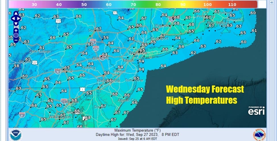
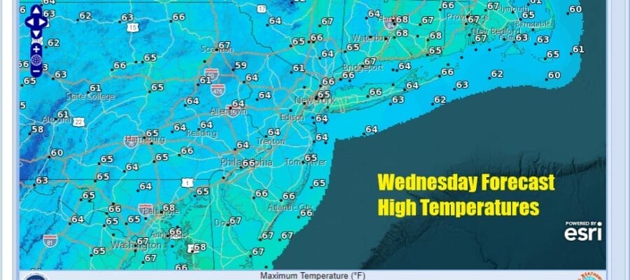
Sometimes even in an onshore flow we catch a break and that is where we are at today. High pressure to the north in Southeastern Canada and New England has been building southward and that has pushed the old east west boundary of clouds and rain further south and east. This puts us in a place where there should be a fair amount of sunshine today from Eastern Pennsylvania to Southern New England. We still have a northeast wind which will keep temperatures down a bit but most highs this afternoon will be in the mid to upper 60s. Radars are nice and quiet today and there are no issues to worry about. Gloom and doom has taken a rest but it does remain close by
SATELLITE WITH LIGHTNING STRIKESGl

WEATHER RADAR

On the satellite loops we can see there are still clouds that extened from the ocean southwestward to along and off the Southeast Coast of the US and Florida. Eventually the high to the north will move east and allow some of that moisture to pivot back northwestward as we move through Thursday and Friday.

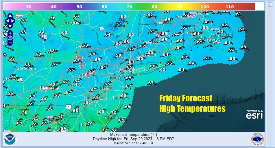
Low pressure develops off the Southeast coast and heads northeast and then also pivots back westward and the southwest off the coast of Virginia. Unlike last week, we do not see this developing into anything beyond a weak low. There won’t be a tropical system that froms from this. This set up brings back clouds later Thursday and Thursday night. Highs Thursday will be in the 60s.

Friday we will be cloudy and we will see rain mostly along coastal areas of New Jersey to NYC and Southern New England. Rain will diminish as you head inland and those areas north and west of the coast likely will just be cloudy Friday with highs in the 60s. We are looking and clouds and some patchy rain to last Friday night into early Saturday morning and then weather conditions will start to improve with leftover clouds and perhaps some developing sunshine Saturday. Friday Highs will be in the 60s. Saturday we should see highs in the upper 60s and lower 70s.

Sunday will be the better of the two weekend days as high pressure builds to the west and winds turn dry northerly. Skies Sunday will be mostly sunny. Highs will be in the low to mid 70s and there will be no issues to deal with on the radars as the offshore low by Sunday heads southwestward toward off the Carolina coast and well offshore.

Next week is looking to be dry possibly all week long and we will likely have warmer than normal temperatures on most days. Monday starts the week with sunshine and highs will reach the mid to upper 70s. We will likely see highs in the mid to upper 70s all week long as long as the onshore flow that develops from time to time behaves itself.
BE SURE TO DOWNLOAD THE FREE METEOROLOGIST JOE CIOFFI WEATHER APP &
ANGRY BEN’S FREE WEATHER APP “THE ANGRY WEATHERMAN!
MANY THANKS TO TROPICAL TIDBITS FOR THE USE OF MAPS
Please note that with regards to any severe weather, tropical storms, or hurricanes, should a storm be threatening, please consult your local National Weather Service office or your local government officials about what action you should be taking to protect life and property.
(Amazon is an affilate of Meteorologist Joe Cioffi & earns commissions on sales.)


