90s Possible Today & Friday Record Highs Shower Chances Over The Weekend

90s Possible Today & Friday Record Highs Shower Chances Over The Weekend
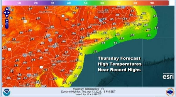
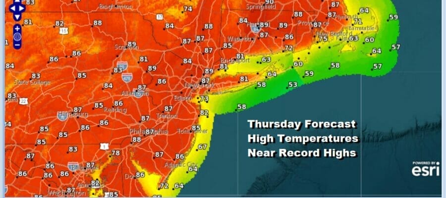
Yesterday we saw temperatures finish 5 or more degrees above what model forecasts were indicating which is a common occurrence in the spring. This leads us to take the same approach with high temperatures today. Much of the guidance is forecasting mid to upper 80s so we will go with upper 80s to lower 90s and that will lead to some record highs. Skies are clear on the satellite so we will have mostly sunny skies pretty much all day long and sea breezes will be confined to the immediate coast in the mid to late afternoon. Radars are totally rain free.
SATELLITE

WEATHER RADAR

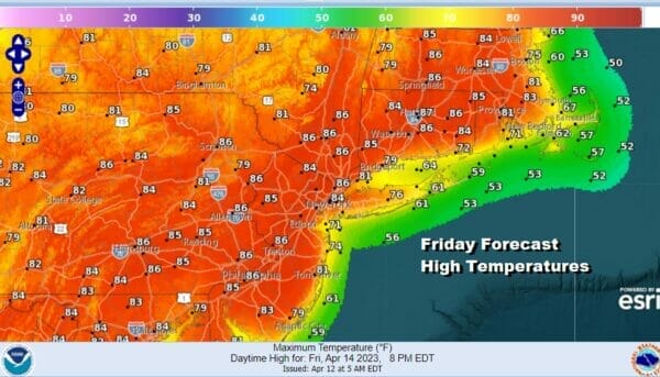
Launching pads to set up these record high temperature runs are important. We will have that Friday morning as lows Thursday night will be in the 50s inland and near 60 in warmer urban areas. Friday will be a repeat perormance of today with a mostly west wind and a good deal of sunshine. Highs again will exceed model forecasts so we are looking at upper 80s to some lower 90s and that could lead to some record highs.
We do see changes over the weekend as high pressure which up until now has been inland in the Southeast US moves offshore and that opens us up to two things. The first is the wind direction which will go from west to south and this will mean that temperatures will be lower over the weekend. Also it opens the door for some moisture to move northward from a low that has been sitting over the Central Gulf Coast the last few days. The upper ridge blocking the low breaks down and the moisture starts to move northward.

Given the fact that we will have a south wind and also we will have more clouds, Temperatures over the weekend will be warm but they will be lower than today and Friday. Also the south wind will mean that south facing shorelines like Long Island and Southern New England will see the more significant temperature change.
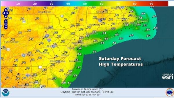
There will be the chance for showers and that too holds temperatures down. Look for highs in the 60s along the coast and in the low to middle 70s inland. The best chance for any showers will be Saturday afternoon and evening but it will a bit uneven when it comes to who sees what and how much.
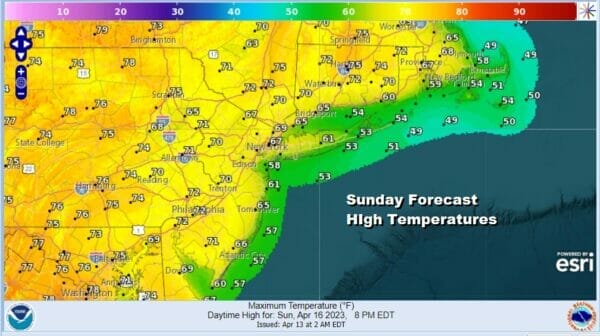
Sunday will also have similar issues with clouds around and a south wind so highs will be in the 60s again along the coast and 70 to 75 inland depending on how much if any sun can break through the clouds. Showers will likely hold off until a cold front passes Monday morning. Next week our weather will return to more typical April as far as temperatures are concerned and it looks to be on the dry side for the most part.
BE SURE TO DOWNLOAD THE FREE METEOROLOGIST JOE CIOFFI WEATHER APP &
ANGRY BEN’S FREE WEATHER APP “THE ANGRY WEATHERMAN!
MANY THANKS TO TROPICAL TIDBITS & F5 WEATHER FOR THE USE OF MAPS
Please note that with regards to any severe weather, tropical storms, or hurricanes, should a storm be threatening, please consult your local National Weather Service office or your local government officials about what action you should be taking to protect life and property.


