Long Island Outside Severe Weather Zone This Evening,
Some Storms Possible Overnight

Weather in 5/Joe & Joe Weather Show Latest Podcast
Long Island Outside Severe Weather Zone This Evening,
Some Storms Possible Overnight
We are seeing severe weather well to the west this evening but for now things are quiet on Long Island. It was a warm humid day. We had ample sunshine and we still have dry conditions that will continue through this evening. Later tonight as a cold front in upstate NY gets close we could see some thunderstorms but we don’t see any activity for the rest of the evening commute.
SATELLITE

Thunderstorms are showing up on the northwest corner of the local radar late this afternoon and we are seeing cells moving northeast but the eastward movement of the lines are limited at the moment. Those storms to the northwest have produced numerous severe thunderstorm warnings and we will see more there this evening.
WEATHER RADAR


As always with this things, the short range models are not capturing all the activity. Timing for Long Island for any storms will be after midnight and some storms seem to linger around daybreak. Thursday could see some lingering showers around under a cloudy sky. Most highs will be in the mid to upper 70s with humidity still on the high side.

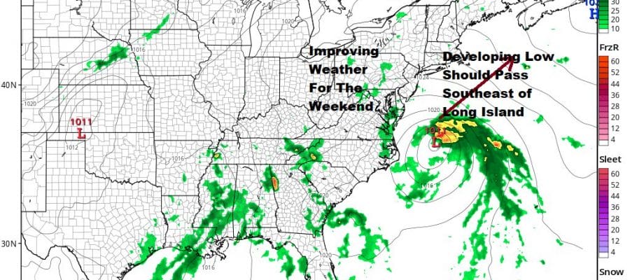
The front stalls overhead which actually may be a good thing. If it had stalled further west it might have opened the door for low pressure developing off the Southeast US coast to move up the coast and bring a more substantial rain Friday. Instead the front on top of us protects us from the low itself. There is a chance this could become a tropical depression or tropical storm. This is likely to kick up the surf Friday into Saturday but all indications are that this system will slide to our south and east.

This will leave us in clouds for Friday with highs in the 70s but we should see improvement over the weekend with developing sunshine Saturday and sunshine for Sunday. Highs both days will be in the mid to upper 70s.
BE SURE TO DOWNLOAD THE FREE METEOROLOGIST JOE CIOFFI WEATHER APP &
ANGRY BEN’S FREE WEATHER APP “THE ANGRY WEATHERMAN!

MANY THANKS TO TROPICAL TIDBITS & F5 WEATHER FOR THE USE OF MAPS
Please note that with regards to any severe weather, tropical storms, or hurricanes, should a storm be threatening, please consult your local National Weather Service office or your local government officials about what action you should be taking to protect life and property.