Tropical Update Latest Developments Friday Video
Tropical Update Latest Developments
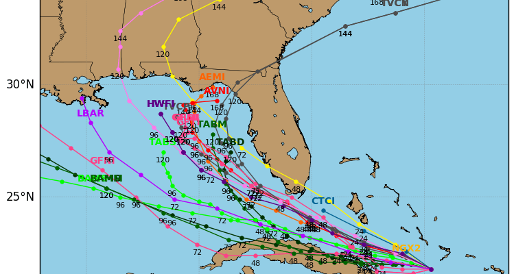
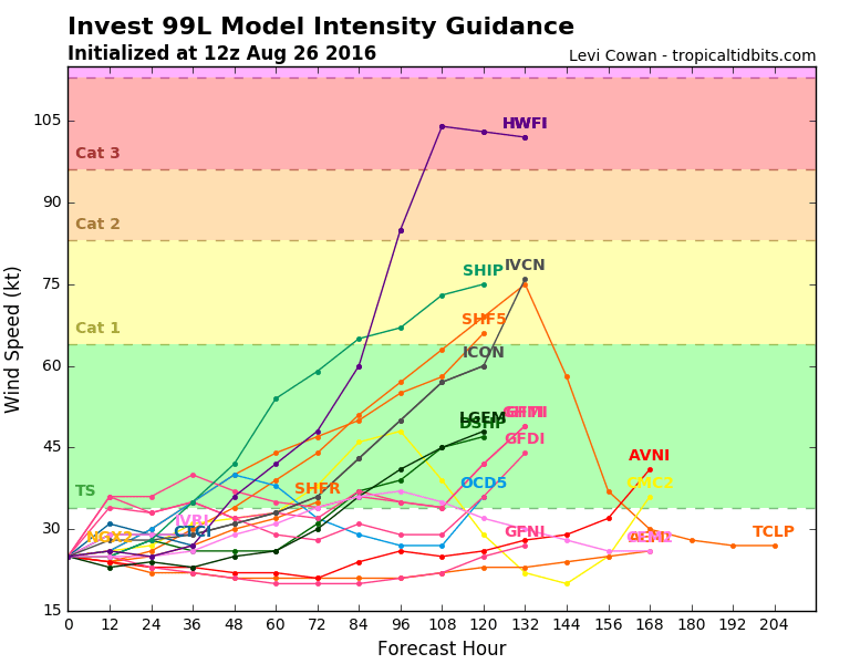
INVEST 99L & TROPICAL STORM GASTON
Latest satellite loops on INVEST99L shows thunderstorms have been increasing somewhat though the center of circulation remains somewhat exposed. Surface observarions show a weak low is there and trying to close off but the terrain of Western Cuba and Haiti continues to hinder that process somewhat. Upper level winds are not conducive for develop at this point however there is still an opportunity for this system to organize once it gets west of 75 degrees west. The thunderstorms that have developed today need to hold together so we will continue to monitor this.
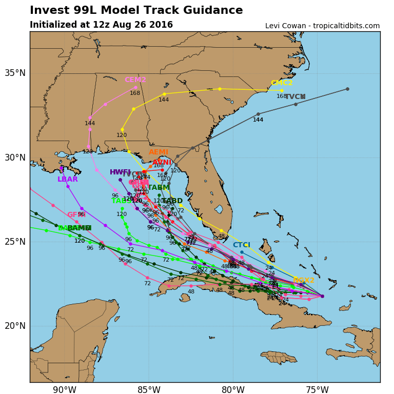
The graphic above shows the spaghetti model forecast tracks. The models show a concentration of tracks into the Eastern Gulf of Mexico. With regards to forecast intensity, most make this a tropical storm Sunday night or Monday with a few of the models taking this to hurricane strength. However the vast majority keep this at tropical storm strength. These are model plots and forecast and they while handy forecast tools, they are not a reflection of what might actually occur. A few of the models don’t do much with this system at all. Climatology would favor intensification in the Eastern Gulf of Mexico assuming some sort of weak circulation actually gets there.

Tropical Update Disturbed Weather Gulf of Mexico
Disturbed weather has also developed in the Gulf of Mexico. Pressures here are rather high and development will appear to be unlikely since much of this activity appears to be moving toward the northwest toward the Texas Louisiana coast.


Tropical Update Tropical Storm Gaston
Tropical Storm Gaston continues to churn about in the open waters of the Atlantic. The tropical storm continues to be sheared by an upper low to the southwest of Gaston. However by this time Saturday shear will have disappeared and Gaston is likely to strengthen to a hurricane again. It remains no threat to land.

...GASTON TURNS TOWARD THE NORTH-NORTHWEST...


SUMMARY OF 1100 AM AST...1500 UTC...INFORMATION
-----------------------------------------------
LOCATION...25.2N 48.3W
ABOUT 1110 MI...1790 KM ESE OF BERMUDA
ABOUT 1065 MI...1715 KM ENE OF THE NORTHERN LEEWARD ISLANDS
MAXIMUM SUSTAINED WINDS...65 MPH...100 KM/H
PRESENT MOVEMENT...NNW OR 330 DEGREES AT 17 MPH...28 KM/H
MINIMUM CENTRAL PRESSURE...997 MB...29.44 INCHES


WATCHES AND WARNINGS
--------------------
There are no coastal watches or warnings in effect.


DISCUSSION AND 48-HOUR OUTLOOK
------------------------------
At 1100 AM AST (1500 UTC), the center of Tropical Storm Gaston was
located near latitude 25.2 North, longitude 48.3 West.  Gaston is
moving toward the north-northwest near 17 mph (28 km/h).  The
system is expected to turn back toward the northwest or west-
northwest at a slower rate of forward speed during the next couple
of days.

Maximum sustained winds are near 65 mph (100 km/h) with higher
gusts.  Some strengthening is forecast during the next 48 hours and
Gaston is expected to become a hurricane again by Saturday.

Tropical-storm-force winds extend outward up to 150 miles (240 km)
from the center.

The estimated minimum central pressure is 997 mb (29.44 inches).


HAZARDS AFFECTING LAND
----------------------
None.
FiOS1 News Weather Forecast For Long Island
FiOS1 News Weather Forecast For New Jersey
FiOS1 News Weather Forecast For Hudson Valley
NATIONAL WEATHER SERVICE SNOW FORECASTS
LATEST JOESTRADAMUS ON THE LONG RANGE
Weather App

Don’t be without Meteorologist Joe Cioffi’s weather app. It is really a meteorologist app because you get my forecasts and my analysis and not some automated computer generated forecast based on the GFS model. This is why your app forecast changes every 6 hours. It is model driven with no human input at all. It gives you an icon, a temperature and no insight whatsoever.
It is a complete weather app to suit your forecast needs. All the weather information you need is right on your phone. Android or I-phone, use it to keep track of all the latest weather information and forecasts. This weather app is also free of advertising so you don’t have to worry about security issues with your device. An accurate forecast and no worries that your device is being compromised.
Use it in conjunction with my website and my facebook and twitter and you have complete weather coverage of all the latest weather and the long range outlook. The website has been redone and upgraded. Its easy to use and everything is archived so you can see how well Joe does or doesn’t do when it comes to forecasts and outlooks.
Just click on the google play button or the apple store button on the sidebar for my app which is on My Weather Concierge. Download the app for free. Subscribe to my forecasts on an ad free environment for just 99 cents a month.
Get my forecasts in the palm of your hand for less than the cost of a cup of Joe!
![]()
![]()