

Weekend Brings Gloom & Doom Saturday & Showery Rains Sunday
Colder Next Week

Showers and thunderstorms overnight are sliding slowly south and east and we will see some slow improvement later today from north to south as drier air arrives. The cold front is going to stall to the south across the Mid Atlantic states and extend westward and southwestward back into Texas where severe weather, thunderstorms, and flash flooding continue today. We will see some breaks of sun and what will turn out to be the best weather day of the next 3 days. Highs today will be generally in the 60s.
SATELLITE WITH LIGHTNING STRIKES

WEATHER RADAR

Unfortunately for those of you hoping for a nice weekend, this is not to be. The frontal boundary to the south will remain stalled through Saturday before it attempts to move northward as a warm front Saturday night and Sunday. Then we have a cold front that will be approaching Sunday and with that front we will likely see some showers and perhaps a few thunderstorms before the front moves offshore by Monday morning.

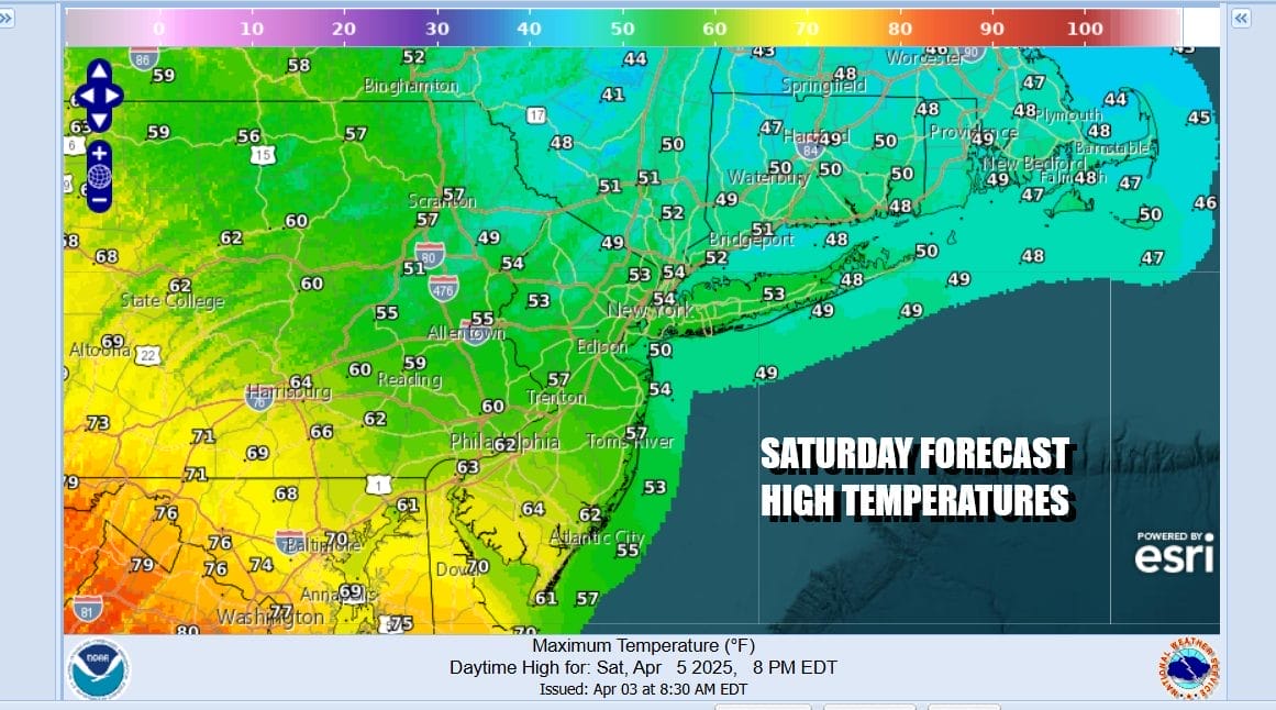
The warm front to the south on Saturday means that we have the curse of the onshore flow to deal with and that is going to mean raw and chilly conditions for most of the area. We will have lots of clouds and there is the chance for some patchy rain or drizzle with a raw east wind. Most highs Saturday will be in the upper 40s north of NYC and Southern New England and mostly 50s everywhere else.
Sunday will be another day where the warm front will try to move northward but of course it will be a challenge to get the front to move far enough north to get us into warmer air. It will probably succeed for Southern New Jersey and points southward but struggle to get north of NYC. We will also see showers and perhaps a few thunderstorms developing Sunday as the day wears on. Highs will range from the 50s north and east of NYC to lower 70s South Jersey and Southern Pennsylvania southward.

For now, severe weather risks for Sunday appear to be from Maryland and Delaware southward. Weather conditions will improve Monday as the cold front heads offshore but we have a much colder than normal weather pattern setting up for next week. A northwest flow from Canada will take over and temperatures will trend below average especially for Tuesday and Wednesday when temperatures will be struggling to get into the 50s at best.
BE SURE TO DOWNLOAD THE FREE METEOROLOGIST JOE CIOFFI WEATHER APP &
ANGRY BEN’S FREE WEATHER APP “THE ANGRY WEATHERMAN!
MANY THANKS TO TROPICAL TIDBITS FOR THE USE OF MAPS
Please note that with regards to any severe weather, tropical storms, or hurricanes, should a storm be threatening, please consult your local National Weather Service office or your local government officials about what action you should be taking to protect life and property.


